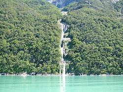
Última Esperanza Sound
Coordinates: 51°28′30″S 73°06′11″W / 51.475°S 73.103°W

Última Esperanza Sound (Spanish: Seno Última Esperanza, ‘Last Hope Sound’) is an inlet stretching from the mouth of Eberhard Fjord to the outskirts of Monte Balmaceda, within the Magallanes Basin. The navigator Juan Ladrillero named it so in 1557, because he felt it was this direction was his last chance to reach the Strait of Magellan. However, he would reach a dead end at a glacier.[1]
This inlet has the characteristics of a tidewater river and drains an extensive basin. It receives the waters of almost all the surface waters of Torres del Paine National Park through the Serrano River. The sound occupies a valley carved by glacial action.[2]
Last Hope Sound along with the Señoret Channel forms a navigation route, which connects Puerto Natales with several protected areas of the region. The Turbio River is a tributary to the Última Esperanza Sound. (This last statement is utter rubbish since the Turbio River is in Argentina, on the other side of a watershed, and the Turbio runs into the Penitente River and ultimately to the Gallegos River and into the Atlantic Ocean, while the waters flowing into Ultima Esperanza flow to the Pacific).
In the vicinity of the Eberhard Fjord is located Cueva del Milodón Natural Monument, where remains have been recovered of the extinct Giant sloth along with a settlement of prehistoric man.[3]
See also
References
- Bailey Willis (1914) Argentina Dirección General de Ferrocarriles Nacionales, Argentina Comisión de Estudios Hidrológicos,Northern Patagonia: Character and Resources, Scribner press, 464 pages
- C. Michael Hogan, Cueva del Milodon, Megalithic Portal, 13 April 2008
-
 This article incorporates text from a publication now in the public domain: Chisholm, Hugh, ed. (1911). Encyclopædia Britannica (11th ed.). Cambridge University Press.
Line notes
- ↑ Mary Heebner, Patagonia, La Última Esperanza
- ↑ B. Willis, 1914
- ↑ C.M.Hogan, 2008