Scald Law
| Scald Law | |
|---|---|
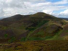
 Scald Law as seen from the northeast | |
| Highest point | |
| Elevation | 579 m (1,900 ft) |
| Prominence | c. 312 m (1,024 ft) |
| Listing | Marilyn, Hardy |
| Coordinates | 55°50′09″N 3°17′24″W / 55.8357°N 3.2901°WCoordinates: 55°50′09″N 3°17′24″W / 55.8357°N 3.2901°W |
| Geography | |
| Location | Midlothian, Scotland |
| OS grid | NT191610 |
| Topo map | OS Landranger 65 |
| Climbing | |
| Easiest route | Hike |
Scald Law is a hill in Midlothian, Scotland. At 579 metres (1900 feet) it is the highest of the Pentland Hills. The hill is composed of Devonian volcanic rock.
The origin of the name is uncertain. Some sources say it derives from the Scots Language word scawed, meaning bare,[1] while another claims it derives from scaldberry, an old name for blackberry.[2]
References
External links
 Media related to Scald Law at Wikimedia Commons
This article is issued from Wikipedia - version of the Thursday, January 07, 2016. The text is available under the Creative Commons Attribution/Share Alike but additional terms may apply for the media files.