Santiago Sacatepéquez
| Santiago Sacatepéquez | |
|---|---|
|
Townhall of Santiago Sacatépéquez | |
 Santiago Sacatepéquez Location in Guatemala | |
 Santiago Sacatepéquez Location in Sacatepequez | |
| Coordinates: 14°39′11″N 90°39′09″W / 14.65306°N 90.65250°W | |
| Country |
|
| Department | Sacatepéquez Department |
| Government[1] | |
| • Mayor (2016-2020) | Juan Carlos Barrios Rodríguez (Convergencia Social Santiago) |

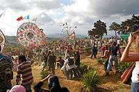
Santiago Sacatepéquez (Spanish pronunciation: [sanˈtjaɣo sakateˈpekes]) is a municipality in the Guatemalan department of Sacatepéquez. It is well known for a kite festival held here annually on November 1.
History
Santiago Sacatepéquez is located in a valley that the Spanish conquistadores called "de Sacatepéquez" (English: Valle of Sacatepéquez) in the 1520s.[2] That valley was bordered by the valley of Xilotepeque on the West, those of Mixco and las Vacas on the North, and by the Chiquimula province and the South and East.[3] The town was described as a rich town with several hundred families and as having "cold climate" by Irish friar Thomas Gage in his 1548 book about his travels through America in the 1620s and 1630s.[4]
In the 1540s, bishop Francisco Marroquín split the ecclesiastical administration of the central valley of Guatemala between the Order of Preachers and the Franciscans, assigning Sumpango's curato to the former.[5] In 1638, the Dominicans separated their large doctrines in groups revolving around six convents:
| Convent | Doctrines or curatos | Convent | Doctrines or curatos |
|---|---|---|---|
| Guatemala |
|
Amatitlán | |
| Verapaz | |||
| Sonsonate |
| ||
| San Salvador |
|
Sacapulas |
Ecclesiastic historian Domingo Juarros wrote that in 1754, by virtue of a royal order of the borbon reforms of king Carlos III all curatos and doctrines of the regular clergy were moved on to the secular clergy.[7] Also, in 1766 the Chimaltenango and Sacatepéquez municipalities tried to join, but it did not work out and they remained split until after independence from Spain in 1821.[8]
Education
|
|
|
Climate
Santiago Sacatepéquez has temperature climate (Köppen: Csb).
| Climate data for Santiago Sacatepéquez | |||||||||||||
|---|---|---|---|---|---|---|---|---|---|---|---|---|---|
| Month | Jan | Feb | Mar | Apr | May | Jun | Jul | Aug | Sep | Oct | Nov | Dec | Year |
| Average high °C (°F) | 20.2 (68.4) |
21.4 (70.5) |
22.7 (72.9) |
23.5 (74.3) |
22.5 (72.5) |
21.0 (69.8) |
21.0 (69.8) |
21.6 (70.9) |
20.9 (69.6) |
20.3 (68.5) |
20.3 (68.5) |
20.3 (68.5) |
21.31 (70.35) |
| Daily mean °C (°F) | 14.7 (58.5) |
15.5 (59.9) |
16.6 (61.9) |
17.7 (63.9) |
17.5 (63.5) |
17.0 (62.6) |
16.7 (62.1) |
16.9 (62.4) |
16.6 (61.9) |
16.0 (60.8) |
15.4 (59.7) |
14.9 (58.8) |
16.29 (61.33) |
| Average low °C (°F) | 9.2 (48.6) |
9.6 (49.3) |
10.5 (50.9) |
11.9 (53.4) |
12.6 (54.7) |
13.0 (55.4) |
12.5 (54.5) |
12.3 (54.1) |
12.4 (54.3) |
11.8 (53.2) |
10.6 (51.1) |
9.6 (49.3) |
11.33 (52.4) |
| Average precipitation mm (inches) | 7 (0.28) |
5 (0.2) |
5 (0.2) |
39 (1.54) |
132 (5.2) |
290 (11.42) |
231 (9.09) |
204 (8.03) |
268 (10.55) |
146 (5.75) |
37 (1.46) |
9 (0.35) |
1,373 (54.07) |
| Source: Climate-Data.org[9] | |||||||||||||
Geographic location

 |
San Pedro Sacatepéquez, Guatemala Department municipality Sumpango, Sacatepéquez Department municiplaity |
 | ||
| Santo Domingo Xenacoj, Sacatepéquez Department municipality | |
Mixco, Guatemala Department municipality[11] | ||
| ||||
| | ||||
| San Bartolome Milpas Altas and San Lucas Sacatepéquez, Sacatepéquez Department municipalities[11] |
See also
- Guatemala portal
- Geography portal
- Chajoma
- La Aurora International Airport
Notes and references
- ↑ Illiterary percentage for people older than 15 years old is 28% with a population of 5274 people younger than 15 year.
References
- ↑ "Alcaldes electos en el departamento de Sacatepéquez". Municipalidades de Guatemala (in Spanish). Guatemala. 8 September 2015. Retrieved 28 October 2015.
- ↑ Juarros 1818, p. 301.
- ↑ Juarros 1818, p. 344.
- ↑ Gage 2014, p. 225.
- ↑ Juarros 1818, p. 336.
- ↑ Belaubre 2001, p. 39.
- ↑ Juarros 1818, p. 338.
- ↑ Juarros 1818, p. 334.
- ↑ "Climate: Santiago Sacatepéquez". Climate-Data.org. Retrieved 19 September 2015.
- ↑ Santiatio Sacatepéquez
- 1 2 SEGEPLAN. "Municipios de Sacatepéquez, Guatemala". Secretaría de Planificación y Programación de la Presidencia (in Spanish). Guatemala. Archived from the original on 29 June 2015. Retrieved 29 June 2015.
Bibliography
- Belaubre, Christopohe (2001). "Poder y redes sociales en Centroamérica: el caso de la Orden de los Dominicos (1757-1829)" (PDF). Mesoamérica (in Spanish) 41. Archived from the original (PDF) on 21 January 2015.
- Gage, Thomas (2014) [1648]. A. P. Newton, ed. The English-American: A New Survey of the West Indies. Routledge. p. 472. ISBN 9781134285143.
- Juarros, Domingo (1818). Compendio de la historia de la Ciudad de Guatemala (in Spanish). Guatemala: Ignacio Beteta.