Santa Lucía de Tirajana
| Santa Lucía de Tirajana | |||
|---|---|---|---|
| Municipality | |||
| |||
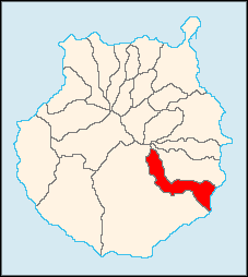
 Municipal location in Gran Canaria | |||
 Santa Lucía de Tirajana Location in the Canary Islands | |||
| Coordinates: 27°54′44″N 15°32′27″W / 27.91222°N 15.54083°WCoordinates: 27°54′44″N 15°32′27″W / 27.91222°N 15.54083°W | |||
| Country | Spain | ||
| Autonomous Community | Canary Islands | ||
| Province | Las Palmas | ||
| Island | Gran Canaria | ||
| Government | |||
| • Mayor | Dunia González Vega (NC) | ||
| Area[1] | |||
| • Total | 61.56 km2 (23.77 sq mi) | ||
| Elevation(AMSL) | 680 m (2,230 ft) | ||
| Population (2013)[2] | |||
| • Total | 68,506 | ||
| • Density | 1,100/km2 (2,900/sq mi) | ||
| Time zone | CET (UTC+0) | ||
| • Summer (DST) | CEST (GMT +1) (UTC+1) | ||
| Postal code | 35110 | ||
| Area code(s) | +34 (Spain) + 928 (Las Palmas) | ||
| Website | www.santaluciagc.com | ||
Santa Lucía de Tirajana is a town and a municipality in the southeastern part of the island of Gran Canaria in the Province of Las Palmas in the Canary Islands. Its population is 68,506 (2013),[2] and the area is 61.56 km².[1] The town Santa Lucía de Tirajana is situated in the mountains, 27 km southwest of Las Palmas. The municipality includes the larger towns Cruce de Sardina, El Doctoral and Vecindario, located near the coast. The GC-1 passes through the southeastern part of the municipality.
Historical population
| Year | Population |
|---|---|
| 1991 | 33,059 |
| 1996 | 40,127 |
| 2001 | 47,652 |
| 2002 | 49,902 |
| 2003 | 52,684 |
| 2004 | 53,820 |
| 2013 | 68,506 |
See also
References
- 1 2 Instituto Canario de Estadística, area
- 1 2 Instituto Canario de Estadística, population
External links
 |
Agüimes |  | ||
| San Bartolomé de Tirajana | |
|||
| ||||
| | ||||
| Atlantic Ocean |
| ||||||||||||||||
This article is issued from Wikipedia - version of the Saturday, December 19, 2015. The text is available under the Creative Commons Attribution/Share Alike but additional terms may apply for the media files.

