Sant'Olcese
| Sant'Olcese | |
|---|---|
| Comune | |
| Comune di Sant'Olcese | |
|
Sant'Olcese | |
 Sant'Olcese Location of Sant'Olcese in Italy | |
| Coordinates: 44°28′N 8°58′E / 44.467°N 8.967°ECoordinates: 44°28′N 8°58′E / 44.467°N 8.967°E | |
| Country | Italy |
| Region | Liguria |
| Province | Province of Genoa (GE) |
| Frazioni | Manesseno, Comago, Arvigo, Torrazza, Casanova, Trensasco, Piccarello, Vicomorasso |
| Area | |
| • Total | 21.9 km2 (8.5 sq mi) |
| Elevation | 300 m (1,000 ft) |
| Population (Dec. 2004) | |
| • Total | 5,945 |
| • Density | 270/km2 (700/sq mi) |
| Demonym(s) | Santolcesini |
| Time zone | CET (UTC+1) |
| • Summer (DST) | CEST (UTC+2) |
| Postal code | 16010 |
| Dialing code | 010 |
| Website | Official website |
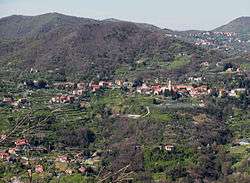
Sant'Olcese is a comune (municipality) in the Province of Genoa in the Italian region of Liguria, located about 6 kilometres (4 mi) north of Genoa. As of 31 December 2004, it had a population of 5,945 and an area of 21.9 square kilometres (8.5 sq mi).[1]
The municipality of Sant'Olcese contains the frazioni (subdivisions, mainly villages and hamlets) Manesseno, Comago, Arvigo, Torrazza, Casanova, Trensasco, Piccarello, and Vicomorasso.
At Comago, the Comune holds the Park & c. 1850 Victorian English country house, the Villa Serra.
This house, built by the Marquis F. Orso Serra, an Anglophile, is one of very few Victorian period English country house designs to be found in Italy. The Park is a member of the Great Gardens of Italy Foundation (Grandi Giardini Italiani) and is open to the public.
Sant'Olcese borders the following municipalities: Genoa, Montoggio, Serra Riccò.
Demographic evolution

Twin towns — Sister cities
Sant'Olcese is twinned with:
-
 Martorelles, Spain (2002)
