Mission San Xavier del Bac
|
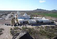
Mission San Xavier del Bac in 2003 | |
 Location of Mission San Xavier del Bac in Arizona | |
| Location | near Tucson, Arizona |
|---|---|
| Coordinates | 32°06′25″N 111°00′29″W / 32.107°N 111.008°WCoordinates: 32°06′25″N 111°00′29″W / 32.107°N 111.008°W |
| Name as founded | La Misión San Xavier del Bac |
| English translation | The Mission of Saint Xavier of the Water |
| Patron | Saint Francis Xavier |
| Nickname(s) | “The White Dove of the Desert” |
| Founding date | 1692 (Current church constructed 1783-1797)[1] |
| Founding priest(s) | Father Eusebio Francisco Kino |
| Native tribe(s) Spanish name(s) | Tohono O’odham |
| Governing body | San Xavier Indian Reservation |
| Current use | Parish Church |
| Designated | October 15, 1966[2] |
| Reference no. | 66000191 |
| Designated | October 9, 1960[3] |
Mission San Xavier del Bac is a historic Spanish Catholic mission located about 10 miles (16 km) south of downtown Tucson, Arizona, on the Tohono O'odham San Xavier Indian Reservation. It was founded in 1692 by Padre Eusebio Kino[1] and named for a pioneering Christian missionary and co-founder of the Society of Jesus (Jesuit Order), Francis Xavier. In 1700 construction began on a church at a site nearby the current Mission. It served the community until razed by Apaches in 1770.
Today's Mission was built between 1783-1797 and is the oldest European structure in Arizona.[1] Widely considered to be the finest example of Spanish Colonial architecture in the United States, it hosts some 200,000 visitors each year.[1]
The site is also known as the “place where the water appears”, as there were once natural springs in the area.[4] The Santa Cruz River, which now runs only part of the year, is also nearby. The Mission is situated in the center of a centuries-old Indian settlement of the Tohono O’odham (formerly known as Papago), located along the banks of the Santa Cruz River.
The Mission is a pilgrimage site, with thousands visiting each year on foot[5] and in horseback cabalgatas.
History
San Xavier Mission was established in 1692 by Father Eusebio Francisco Kino, founder of the Spanish missions in the Sonoran Desert chain. A Jesuit of Italian descent, he often visited and preached in the area, then the Pimería Alta territory of the Viceroyalty of New Spain.[1] Construction of the first mission church about two miles (3 km) from the site of today's Mission began on April 28, 1700, as noted in his diary:
"On the twenty-eighth we began the foundations of a very large and capacious church and house of San Xavier del Bac, all of the many people working with much pleasure and zeal, some in digging for the foundations, others in hauling many and very good stones of tezontle from a little hill which was about a quarter of a league away.....On the twenty-ninth we continued laying the foundations of the church and of the house..." (from Kino's Historical Memoir of Pimeria Alta, edited by Herbert Eugene Bolton, University of California Press, 1948, pp. 235-236)
The "little hill" is believed to be that southeast of San Xavier del Bac. Charles III of Spain distrusted Jesuits and banned them from Spanish lands in the Americas in 1767; more pliable and “reliable” Franciscans were installed as replacements. The original church proved vulnerable to Apache attacks, which finally destroyed it in about 1770. From 1775 on the mission community and its Indian converts were protected somewhat from Apache raids by the Presidio San Augustin del Tucson, established roughly seven miles downstream.
The present Mission building was constructed under the direction of Franciscan fathers Juan Bautista Velderrain and Juan Bautista Llorenz between 1783 and 1797.[1] With 7,000 pesos borrowed from a Sonoran rancher, they hired architect Ignacio Gaona, who employed a large workforce of O'odham to create today's church.[1]
Following Mexican independence in 1821, what was then Alta California was administered from Mexico City. In 1822, the Mission fell under the jurisdiction of the Catholic Diocese of Sonora. In 1828, the Mexican government banned all Spanish-born priests, with the last resident Franciscan departing San Xavier for Spain in 1837.
Left vacant, the Mission began to decay. Concerned about their church, local Indians began to preserve what they could. With the Gadsden Purchase in 1854, San Xavier was brought under U.S. rule as part of the Territory of Arizona. The church was re-opened in 1859 when the Santa Fe Diocese added the Mission to its jurisdiction. It ordered repairs paid for with diocesean money, and assigned a priest to serve the community. In 1868 the Diocese of Tucson was established and regular services were held at the church once again.
In 1872 the Sisters of St. Joseph of Carondelet opened a school at the Mission. In 1895 a grant of $1,000 was given to repair the building. More classrooms were added in 1900. The Franciscans returned to the Mission in 1913. In 1947, a new school was built next to the church for the Tohono O’odham children.
Renovation
Extensive restoration in the late 20th century has returned the Mission interior to its historic splendor. Cement-based stucco added in the 1980s trapped water inside the church and damaged its interior decorations. It is being removed and replaced with traditional mud plaster incorporating pulp from the prickly pear cactus that “breathes” better and allows excess water to escape but requires more frequent inspection and has higher maintenance costs. Following extensive and ongoing restoration of decorations, the Mission church interior now largely appears in its original state, with brilliant colors and complex designs.[1]
Architecture
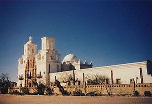
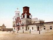
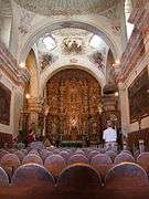
San Xavier has an elegant white stucco Moorish-inspired exterior, with an ornately decorated entrance. Visitors entering the massive, carved mesquite-wood doors are often struck both by the coolness of the interior and the dazzling colors of the paintings, carvings, frescoes and statues. Its rich ornamentation displays a mixture of New Spain and Native American artistic motifs.
The floor plan of the church resembles the classic Latin cross, with a main aisle separated from the sanctuary by the transept, which has chapels at either end. The dome above the transept is 52 feet (16 m) high, supported by arches and squinches. At least three different artists painted the artwork inside the church. It is considered by many to be the finest example of Spanish mission architecture in the United States.[1]
The Mission was declared a National Historic Landmark in 1960.[6][7]
Gallery
| Mission San Xavier del Bac | ||||||||||||||||
|---|---|---|---|---|---|---|---|---|---|---|---|---|---|---|---|---|
|
Mission today

Unlike the other Spanish missions in Arizona, San Xavier is still actively run by Franciscans, and continues to serve the Native community by which it was built. Widely considered to be the finest example of Spanish Colonial architecture in the United States, the Mission hosts some 200,000 visitors each year.[1] It is open to the public daily, except when being used for church services.
The Franciscan Sisters of Christian Charity, who have taught at the school since 1872, continue with their work and reside in the Mission convent.
The San Xavier Festival is held the evening of the Friday after Easter and features a torch-light parade of Tohono O’odham and Yaqui tribal members.
Nearby communities
Martinez Hill
To the east of the San Xavier Mission, bordering the I-19 Freeway, is Martinez Hill. This hill, according to historian David Leighton is named in honor of Jose Maria Martinez. Mr. Martinez was born in the Pimeria Alta (present-day northern Sonora and southern Arizona), in the early 1800s. Around 1833 Jose wed Felipa Yrigoyen, likely in Tubac, Sonora. The couple had many children, including Maria and Nicolas Martinez. From 1836 to 1838, Lt. Col. Jose Maria Martinez, was in charge of the presidio in Tucson. In 1838 he retired from the military and was given land in Tubac. Ten years later, an attack by Apache Indians, forced the residents to abandon the town, with most moving to Tucson, but the Martinez family relocated to San Xavier, where he was granted land by the chief. The hill that bears his name was either included in the land grant or was very close to it. Martinez went into the cattle business for many years and would die from wounds suffered in an Apache attack, in 1868.[8]
Los Reales
To the north of San Xavier Mission existed the Los Reales community. The community (sometimes referred to as a town or village), which is believed to have existed from about the early 1860s to about 1912 had long been forgotten until an article in the Arizona Daily Star newspaper, by historian David Leighton, brought it to light. The community was started when a miner named S.R. Domingo built a home and foundry just north of the San Xavier Mission, on the west bank of the Santa Cruz River. He prospered in his mining endeavor and is believed to have kept his wealth buried in the tall grasses along the river, since no banks existed, at the time. In time, other individuals came to the area and began farms in the fertile valley, supported by the ever-flowing river and the community grew. They built adobe homes, planted crops and established the first Los Reales community. Domingo is believed to have been murdered in the late 1860s, by miners he had hired to work his mine, but it is unknown what happened to his riches.[9]
In 1874, President Ulysses S. Grant established the San Xavier Indian Reservation and all non-Native Americans were forced to leave the Indian lands. As a result, these individuals forced to leave, set up the new or second Los Reales on the east bank of the river. This new community across from the old Los Reales included two stores and a blacksmith shop nearby. The Los Reales Cemetery also existed on that side of the river. It's believed that in 1912, as a result of the Midvale Farms (now the Midvale Park neighborhood) taking much of the water from the river, the then farming village ceased to exist. The only known remnants of the old town, are parts of the cemetery and a street known as Los Reales Road.[9]
See also
- Spanish missions in Arizona
- Spanish Missions in the Sonoran Desert
- Spanish missions in California
- Architecture of the California missions
- List of the oldest churches in the United States
References
- 1 2 3 4 5 6 7 8 9 10 San Xavier Mission Organization site
- ↑ Staff (2007-01-23). "National Register Information System". National Register of Historic Places. National Park Service.
- ↑ "San Xavier Del Bac Mission". National Historic Landmark summary listing. National Park Service. Retrieved 2008-06-15.
- ↑ (Nentvig, J. 1980. Rudo Ensayo: A Description of Sonora and Arizona in 1764. University of Arizona Press, Tucson, AZ)
- ↑ Fontana, Bernard L. & photos by McCain,Edward, "A Gift of Angels: The Art of Mission San Xavier del Bac", p. 41, The University of Arizona Press, Tucson, 2010, ISBN 978-0-8165-2840-0
- ↑ "San Xavier del Bac Mission". National Historic Landmark summary listing. National Park Service. Retrieved 2007-09-27.
- ↑ Marilynn Larew (February 1978). "National Register of Historic Places Inventory-Nomination: San Xavier del Bac Mission" (PDF). National Park Service. Retrieved 2009-05-05. and Accompanying 16 photos, 15 by Marilynn Larew from 1977, 1 from 1877 after earthquake.
- ↑ David Leighton, "Street Smarts: Hill, road honor Mexican military commander," Arizona Daily Star, August 26, 2014
- 1 2 David Leighton, "Street Smarts: Bloody murder, buried money in town's history (Los Reales)," Arizona Daily Star, Dec. 16, 2014
Nentvig, J. 1980. Rudo Ensayo: A Description of Sonora and Arizona in 1764. University of Arizona Press, Tucson, AZ
External links
| Wikimedia Commons has media related to San Xavier del Bac. |
- Official Mission San Xavier del Bac website
- Mission of San Xavier del Bac article at the Catholic Encyclopedia
- Online book on Mission San Xavier del Bac
- Historic American Buildings Survey (HABS) No. AZ-13, "San Xavier del Bac Mission, Mission Road, Tucson, Pima County, AZ", 207 photos, 42 measured drawings, 9 data pages
- American Southwest, a National Park Service Discover Our Shared Heritage Travel Itinerary
| ||||||
| ||||||||||||||||||||||||||
| ||||||


