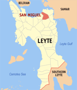
San Miguel, Leyte
| San Miguel | |
|---|---|
| Municipality | |
 Map of Leyte with San Miguel highlighted | |
.svg.png) San Miguel Location within the Philippines | |
| Coordinates: 11°16′N 124°50′E / 11.267°N 124.833°ECoordinates: 11°16′N 124°50′E / 11.267°N 124.833°E | |
| Country | Philippines |
| Region | Eastern Visayas (Region VIII) |
| Province | Leyte |
| Congr. district | 1st district of Leyte |
| Barangays | 21 |
| Government[1] | |
| • Mayor | Cheeryl Enrica L. Esperas |
| Area[2] | |
| • Total | 145.11 km2 (56.03 sq mi) |
| Population (2010)[3] | |
| • Total | 17,561 |
| • Density | 120/km2 (310/sq mi) |
| Time zone | PST (UTC+8) |
| ZIP code | 6518 |
| Dialing code | 53 |
San Miguel is a fourth class municipality in the province of Leyte, Philippines. According to the 2010 census, it has a population of 17,561 people.[3]
Barangays
San Miguel is politically subdivided into 21 barangays.[2]
- Bagacay
- Bahay
- Bairan
- Cabatianuhan
- Canap
- Capilihan
- Caraycaray
- Libtong (East Poblacion)
- Guinciaman
- Impo
- Kinalumsan
- Lukay
- Malaguinabot
- Malpag
- Mawodpawod
- Patong
- Pinarigusan
- San Andres
- Santa Cruz
- Santol
- Cayare (West Poblacion)
History
According to the manuscript written by Lorenzo Babula, one of the old town executives of this municipality, the first people were only few then so their homes were scattered in the forests where they tilled land for subsistence. Later, some settled along the seashore and they fished for food and as a means of livelihood.
As time went on, many of them lived in a place called "Sabang" which means mouth of the river then later it became a small barrio. This was the period when the "Moros" from Jolo who were pirates forced women to go with them to Mindanao so they couldbe sold to their "datu" or ruler as cooks or laundrywomen.
Demographics
| Population census of San Miguel | ||
|---|---|---|
| Year | Pop. | ±% p.a. |
| 1990 | 13,438 | — |
| 1995 | 14,504 | +1.44% |
| 2000 | 15,153 | +0.94% |
| 2007 | 16,527 | +1.20% |
| 2010 | 17,561 | +2.23% |
| Source: National Statistics Office[3] | ||
References
- ↑ "Municipalities". Quezon City, Philippines: Department of the Interior and Local Government. Retrieved 19 June 2013.
- 1 2 "Province: Leyte". PSGC Interactive. Makati City, Philippines: National Statistical Coordination Board. Retrieved 19 June 2013.
- 1 2 3 "Total Population by Province, City, Municipality and Barangay: as of May 1, 2010" (PDF). 2010 Census of Population and Housing. National Statistics Office. Retrieved 19 June 2013.
External links
- Philippine Standard Geographic Code
- Philippine Census Information
- Local Governance Performance Management System
 |
Carigara Bay | |
Babatngon |  |
| Barugo | |
|||
| ||||
| | ||||
| Alangalang | Tacloban |
| ||||||||||||||||||||||