San Esteban, Ilocos Sur
| San Esteban | ||
|---|---|---|
| Municipality | ||
|
Barangay Cabaroan, San Esteban | ||
| ||
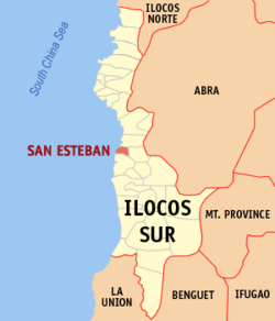
 Map of Ilocos Sur showing the location of San Esteban | ||
.svg.png) San Esteban Location within the Philippines | ||
| Coordinates: 17°20′N 120°27′E / 17.333°N 120.450°ECoordinates: 17°20′N 120°27′E / 17.333°N 120.450°E | ||
| Country | Philippines | |
| Region | Ilocos (Region I) | |
| Province | Ilocos Sur | |
| District | 2nd District | |
| Barangays | 10 | |
| Government[1] | ||
| • Mayor | Chester A. Elaydo | |
| Area[2] | ||
| • Total | 19.62 km2 (7.58 sq mi) | |
| Population (2010)[3] | ||
| • Total | 8,072 | |
| • Density | 410/km2 (1,100/sq mi) | |
| Time zone | PST (UTC+8) | |
| ZIP code | 2706 | |
| Dialing code | 77 | |
| Income class | 5th class | |
San Esteban is a fifth class municipality in the province of Ilocos Sur, Philippines. According to the 2010 census, it has a population of 8,072 people.[3]
Barangays
San Esteban is politically subdivided into 10 barangays.[2]
- Ansad
- Apatot
- Bateria
- Cabaroan
- Cappa-Cappa
- Poblacion
- San Nicolas
- San Pablo
- San Rafael
- Villa Quirino
Etymology
The Spaniards named the pueblo (the equivalent of a municipality in present-day terms) San Esteban (formerly known as Cabagbagototan) because they have received reports of a vagabond named Iban having been stoned to death and beheaded by hostile natives in the place called "Naglawlawayan," which is an early place of worship by the natives, and currently the site of the municipal cemetery. "Iban" is the Ilocano equivalent of "Stephen," hence the pueblo being named San Esteban.
San Esteban was founded by Agustinian friars in 1625, but was always attached to Nueva Coveta (present-day Burgos) and to the municipality of Santiago until 1911. It was once a visita of Narvacan because of a shortage of ministers.
Demographics
| Population census of San Esteban | ||
|---|---|---|
| Year | Pop. | ±% p.a. |
| 1990 | 6,327 | — |
| 1995 | 6,508 | +0.53% |
| 2000 | 7,174 | +2.11% |
| 2007 | 7,779 | +1.12% |
| 2010 | 8,072 | +1.35% |
| Source: National Statistics Office[3][4] | ||
References
- ↑ "Official City/Municipal 2013 Election Results". Intramuros, Manila, Philippines: Commission on Elections (COMELEC). 1 July 2013. Retrieved 23 September 2013.
- 1 2 "Province: ILOCOS SUR". PSGC Interactive. Makati City, Philippines: National Statistical Coordination Board. Retrieved 23 September 2013.
- 1 2 3 "Total Population by Province, City, Municipality and Barangay: as of May 1, 2010" (PDF). 2010 Census of Population and Housing. National Statistics Office. Retrieved 23 September 2013.
- ↑ "Province of Ilocos Sur". Municipality Population Data. LWUA Research Division. Retrieved 20 September 2013.
External links
- Pasyalang Ilocos Sur
- San Esteban website
- Philippine Standard Geographic Code
- Philippine Census Information
- Local Governance Performance Management System
 |
Santa Maria |  | ||
| South China Sea | |
Burgos | ||
| ||||
| | ||||
| Santiago |

