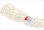
Salyantar
| Salyantar सल्यानटार | |
|---|---|
| Village development committee | |
 Salyantar Location in Nepal | |
| Coordinates: 27°59′N 84°49′E / 27.99°N 84.81°ECoordinates: 27°59′N 84°49′E / 27.99°N 84.81°E | |
| Country |
|
| Zone | Bagmati Zone |
| District | Dhading District |
| Population (1991) | |
| • Total | 6,196 |
| • Religions | Hindu |
| Time zone | Nepal Time (UTC+5:45) |
Salyantar is a village development committee in Dhading District in the Bagmati Zone of central Nepal.It is the biggest as well as longest tar of Nepal. At the time of the 1991 Nepal census it had a population of 6196 and had 1110 houses in it.The major casts living in salyantar are kumal and darai. millet and pulse are the major products of salyantar. there is a Health Facility in salyantar called as Salyantar Primary Health Care Centre. salyantar is surrounded by four rivers viz. Budhigandaki in West, Netrawoti(aankhu khola) in South, Hyapinge in East and Kaste in North but it is table like place. [1]
References
- ↑ "Nepal Census 2001". Nepal's Village Development Committees. Digital Himalaya. Retrieved 2008-08-24.
This article is issued from Wikipedia - version of the Sunday, September 29, 2013. The text is available under the Creative Commons Attribution/Share Alike but additional terms may apply for the media files.
