Saltes Island
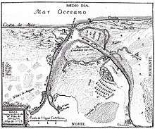
Saltes Island (Spanish: Isla Saltés) is a small fluvial island located in the Huelva River estuary, near the Andalusian towns Huelva and Punta Umbría. Today the island belongs to the natural park of marshes of the Odiel.
Geography

The area is the second largest wetland in Andalusia. Its sandy soil hosts an important ecosystem of flora and fauna, including species of spoonbills, flamingos, egrets and storks.
Remains of the city of Salthish
In addition to its ecological value as an area of marshes and nesting birds, the island is known for its archaeological value. It is often thought of as the location of the semi-mythical city of Tartessos. The Roman poet Avienus in his Maritime Ora, referred to the "island between two rivers". Previously, Strabo (III, 5.5) spoke of the trips of the Phoenician sailors to the area from the eighth century whose oracle tells them to build a temple to Hercules. The truth is that between the legend and the Biblical reference -the Tarschish of "The Book of Kings" - Tartessos contacts with the Greek world in the mid-seventh century.
While also been recently confirmed the existence of Roman installations related to fishing and sea salt production, what stands out are the remains of the city from the Islamic period. The city is situated chronologically to the tenth and eleventh centuries, especially the Taifa of Baikríes first, and Mr. Taifa Kingdom of Umba and Xaltis Saltés- -Huelva and (later) under the reign of Abd al-Aziz al-Bakri. From 1052 its slow abandonment occurs when al-Bakri domains are conquered by al-Mutadid and is bordered on the island. In Christian times the city had been abandoned there only some civilians (leprosy) and religious (hermitage) facilities. Today the grounds of the city are in a space of private ownership.
Studies estimate that the city had an unusually regular basis to the Arab model, and a central fortress of 70x40 meters perimeter. The population was devoted to trade metal and metallurgy, taking advantage of the proximity to the northern mines whose minerals came to the city by the nearby Onuba (now known as Rio Tinto). The city is also engaged in fishing and trade due to its maritime location.
References
- Junta de Andalucía. Gabinete pedagógico de bellas artes.
- Gerencia Municipal de Urbanismo. "Huelva, gestión de ciudad". Ayuntamiento de Huelva 2002.
External links
Coordinates: 37°09′45″N 6°54′12″W / 37.16250°N 6.90333°W