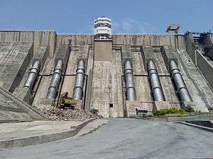
Salal Hydroelectric Power Station
Salal Hydroelectric Power Station, Stage-I of 345 MW (115X3) and Stage-II of 345 MW (115X3), is constructed on river Chenab (Chandrabhaga in Sanskrit) in the state of Jammu & Kashmir. The project was conceived in 1920. TSXCVBNM,.he feasibility studies on the project commenced in 1961 by the state government of J&K and construction was started in 1970 by Central Hydroelectric Project Control Board under Ministry of Irrigation and Power. In 1978 construction of the projects was entrusted to NHPC on agency basis. After completion of project, it was handed over to NHPC on ownership basis for Operation and Maintenance. Stage-I of the project was commissioned in 1987. First unit of Stage-II of the project was commissioned in 1993, second in 1994 and third in 1995. At the peak of construction, about 12,000 personnel including contractors worked around the clock to complete the project from 1970s to present day, under proper guidance and maintenance of India's most successful company NHPC (NATIONAL HYDROELECTRIC POWER CORPORATION. The project was taken by HCC and various contractors.
Power from the project is transmitted to the Northern Grid where it is distributed to the states of Jammu and Kashmir, Punjab, Haryana, Delhi, Himachal Pradesh, Rajasthan, and Uttar Pradesh, and the union territory of Chandigarh.
Salient features
- Location Distt. Reasi, J & K
- Approach Nearest Rail Head - Katra
- Capacity 690 MW
- Annual Generation 3101 million units
- Project Cost Rs. 9288.9 million
- Baneficiary States U.P, J&K, Punjab, Haryana, Delhi, H.P. Chandigarh & Rajasthan
- Tariff rate 41.56 Paise / Unit
- Year of Commissioning/Completion Schedule Stage-I 1987 Stage-II 1st unit-1993 2nd unit-1994 3rd unit-1995. Finally Commissioned in 1996
Technical features
- 118 m high, 630m long rockfill dam.
- 113 m high, 450 m long concrete dam
- 11 m dia, 2.46 km long tail race tunnel.
- 6 nos. Penstocks 5.23 m dia, 279 m long each.
- Sub-surface power house containing 6 units of 115 MW each.
Location
Concrete dam

- Max height : 113 m
- Length of top : 450 m
- Full Reservoir level : 487.68 m
- Maximum water level : 494.08 m
- Length of spillway : 220 m
- Length of power dam : 105 m
- Length of non overflow dam : 125 m
- Spillway design discharge : 22,500 m³/s
- No of spillway bays : 12
- Type of gate : Radial
- Top elevation : 495.91 m
- Deepest foundation level : 383 m
- No of river sluices : 6 of 3.35 m x 4.57 m
Power house

- Generating units : 6
- Rated capacity of each unit : 115 MW
Tailrace tunnel
- Number : Two
- Length Stage I : 2.463 km
- Stage II : 2.523 km
- Shape : Horseshoe
- Diameter : 11 m (finished)
- Design discharge : 412 m³/s
- Velocity : 4.2 m/s
Transmission lines
- Name of Grid : Northern grid
- Transmission Voltage : 220 kV
- Total length of lines : 446 km
- Double circuit Salal- Kishenpur : 2 lines
- Single circuit Salal-Jammu : 2 lines
See also
References
- ↑ NHPC Salal
External links
| ||||||||||||||
Coordinates: 33°8′26″N 74°48′27″E / 33.14056°N 74.80750°E
