Running Water, South Dakota
| Running Water, South Dakota | |
|---|---|
| Census-designated place | |
|
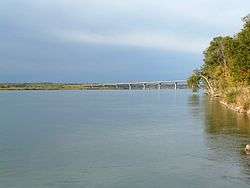
Looking toward the Chief Standing Bear Bridge near the boat ramp | |
 Running Water | |
| Coordinates: 42°46′12″N 97°59′2″W / 42.77000°N 97.98389°WCoordinates: 42°46′12″N 97°59′2″W / 42.77000°N 97.98389°W | |
| Country | United States |
| State | South Dakota |
| County | Bon Homme |
| Area | |
| • Total | 2.1 sq mi (5.4 km2) |
| • Land | 2.1 sq mi (5.4 km2) |
| • Water | 0 sq mi (0 km2) |
| Elevation | 1,251 ft (381 m) |
| Population (2010) | |
| • Total | 36 |
| • Density | 17/sq mi (6.6/km2) |
| Time zone | Central (CST) (UTC-6) |
| • Summer (DST) | CDT (UTC-5) |
| Area code(s) | 605 |
| FIPS code | 46-56820[1] |
| GNIS feature ID | 1257520[2] |
Running Water is a census-designated place (CDP) in Bon Homme County, South Dakota, United States. The population was 36 at the 2010 census.[3]
The community's name Running Water is a former variant name of the nearby Niobrara River.[4]
Geography
Running Water is located on the north side of the Missouri River in southern Bon Homme County along the South Dakota-Nebraska state line. South Dakota Highway 37 crosses the Missouri at Running Water, becoming Nebraska Highway 14 on the opposite shore. SD 37 leads north and east 10 miles (16 km) to Springfield, and NE 14 leads south and west 3 miles (5 km) to Niobrara.
According to the United States Census Bureau, the Running Water CDP has a total area of 2.1 square miles (5.4 km2), all of it land.[3]
References
- ↑ "American FactFinder". United States Census Bureau. Retrieved 2008-01-31.
- ↑ "US Board on Geographic Names". United States Geological Survey. 2007-10-25. Retrieved 2008-01-31.
- 1 2 "Geographic Identifiers: 2010 Demographic Profile Data (G001): Running Water CDP, South Dakota". U.S. Census Bureau, American Factfinder. Retrieved April 7, 2014.
- ↑ Federal Writers' Project (1940). South Dakota place-names, v.1-3. University of South Dakota. p. 59.
| |||||||||||||||||||||||||
This article is issued from Wikipedia - version of the Thursday, February 04, 2016. The text is available under the Creative Commons Attribution/Share Alike but additional terms may apply for the media files.

