Roxwell

| Roxwell | |
 Village sign and church |
|
 Roxwell |
|
| Population | 1,044 (2011 Census) |
|---|---|
| Civil parish | Roxwell |
| District | Chelmsford |
| Shire county | Essex |
| Region | East |
| Country | England |
| Sovereign state | United Kingdom |
| Post town | Chelmsford |
| Postcode district | CM1 |
| Police | Essex |
| Fire | Essex |
| Ambulance | East of England |
| EU Parliament | East of England |
Coordinates: 51°44′48″N 0°24′24″E / 51.746660805871°N 0.4065843830724°ERoxwell is a village and civil parish in the Chelmsford District of Essex England. The village is approximately 4 miles (6 km) west from the centre of the county town of Chelmsford, and to the south of the A1060 road, on which is the hamlet of Boyton Cross.

The Anglican parish church of St Michael and All Angels dates from the 14th century and is a Grade II* listed building.[1] There is a primary school, The Chequers public house, and a village store/post office.
The original Roxwell cricket club disbanded in 2004 when membership fell to an unsustainable level. In July and August 2004 the ground was used by Havering Blues team for its last three home games in the T Rippon Mid Essex League. The Blues have played at Stonehill Road since that time and from 2006 adopted the name Roxwell Blues. The Roxwell Brook flows north of the village.
In 1870-72, Roxwell was described as:
"a parish, with a village, in Chelmsford district, Essex; on the river Chelmer, 4½ miles W by N of Chelmsford r. station."[2]
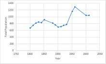
It had a population of 1,044 according to the 2011 census.[3]
References
- ↑ Historic England. "Church of St Michael and All Angels, The Street (1235784)". National Heritage List for England. Retrieved 3 May 2015.
- ↑ Wilson, John Marius (1870–72). "Imperial Gazetteer of England and Wales". visionofbritain. A. Fullerton & Co. Retrieved 28 January 2016.
- ↑ "Roxwell (Parish): Key figures for the 2011 Census: Key Statisitcs". Neighbourhood Statistics. Office for National Statistics. Retrieved 28 January 2016.
External links
![]() Media related to Roxwell at Wikimedia Commons
Media related to Roxwell at Wikimedia Commons

| ||||||||||||||||||||||||||
| ||||||||||||||||||||||