East Rounton
Coordinates: 54°25′26″N 1°21′02″W / 54.42383°N 1.35057°W

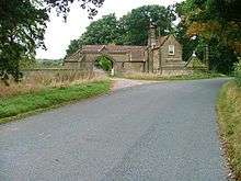
The Lodge, Rounton Grange, near East Rounton
East Rounton is a village and civil parish in the Hambleton district of North Yorkshire, England. It is about 1 mile west of the A19 and 8 miles north-east of Northallerton. It is on the River Wiske and West Rounton is nearby. The population taken at the 2011 Census was less than 100. Details are included in the civil parish of West Rounton.
East Rounton was the site of Rounton Grange, a country house designed by the architect Philip Webb in 1872 to 1876 for the industrialist Lowthian Bell. It was demolished in 1953.[1]
References
- ↑ Peter Burman. "An Introduction to the East Rounton Estate" (PDF). Retrieved 28 February 2015.
External links
![]() Media related to East Rounton at Wikimedia Commons
Media related to East Rounton at Wikimedia Commons
This article is issued from Wikipedia - version of the Sunday, February 07, 2016. The text is available under the Creative Commons Attribution/Share Alike but additional terms may apply for the media files.
