Rodenberg
| Rodenberg | ||
|---|---|---|
| ||
 Rodenberg | ||
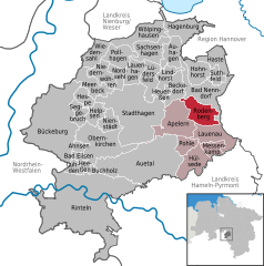
Location of Rodenberg within Schaumburg district 
 | ||
| Coordinates: 52°19′N 9°21′E / 52.317°N 9.350°ECoordinates: 52°19′N 9°21′E / 52.317°N 9.350°E | ||
| Country | Germany | |
| State | Lower Saxony | |
| District | Schaumburg | |
| Municipal assoc. | Rodenberg | |
| Government | ||
| • Mayor | Ralf Sassmann (WGR) | |
| Area | ||
| • Total | 15.6 km2 (6.0 sq mi) | |
| Population (2013-12-31)[1] | ||
| • Total | 6,244 | |
| • Density | 400/km2 (1,000/sq mi) | |
| Time zone | CET/CEST (UTC+1/+2) | |
| Postal codes | 31552 | |
| Dialling codes | 05723 | |
| Vehicle registration | SHG | |
Rodenberg is a town in the district of Schaumburg, in Lower Saxony, Germany. It is situated on the northwestern edge of the Deister hills, approx. 10 km east of Stadthagen, and 27 km west of Hanover.
Rodenberg is also the seat of the Samtgemeinde Rodenberg ("collective municipality").
Geography
The town of Rodenberg lies between the Deister, Süntel and Bückeberg ridges. The Rodenberger Aue and Steinaue streams flow through the town. The "old Rodenberg" hill, which gives the town its name, with its landmark windmill, rises to the west of the town. Since 1974, the parish of Rodenberg includes the formerly independent parish of Algesdorf. The neighbouring village of Grove, with its church, was amalgamated with Rodenberg in 1834.
History
The neighbourhood of Rodenberg was already settled in prehistoric times, inter alia by the Celts and Saxons. This is also witnessed by some barrows in the vicinity. The name Rodenberg refers to a hill to the west of the town, and the name does not refer to a clearing but to the red colour of the hill: "roter Berg".
According to the earliest record of the town, the predecessors of the Counts of Schaumburg erected a castle or peel tower here in 930; unfortunately no more details are known.
It is presumed that the moated castle was established by Adolf IV, Count of Schaumburg between 1228 and 1240, and that the previous castle of 930 was located on the so-called "old Rodenberg" to the west of the town.
The current spelling of Rodenberg was first used in 1632. A wide variety of other spellings are recorded between 1317 and 1586.
The town was legally recognised as a settlement in 1250, and in 1615 as a town by Ernest, Count of Schaumburg. The line of Counts of Schaumburg was extinguished in 1640 on the death of Count Otto V, and in 1647 the town was absorbed by the Landgraviate of Hesse-Kassel (or Hesse-Cassel) - a position that was formally consolidated by the Treaty of Westphalia in 1648.
A widely known spa was established in 1718 and was very popular until 1787 when Landgrave William IX established a spa at the sulphur springs in neighbouring Bad Nenndorf.
In 1859 much of the town burned down. In the years that followed, the stones from the fortifications were recycled to various new buildings in the town and also in Bad Nenndorf.
When Hesse was annexed by Prussia in 1866, the Rinteln district (as it was called between 1866–1904) became part of the Prussian province of Hesse-Nassau, as it remained until it was incorporated into the province of Hanover following the local government reforms of 1932.
This part of Schaumburg also belongs to the Evangelical Lutheran Church district of Hanover.
Prior to the abolition of Government Districts in Lower Saxony in 2004, Rodenberg belonged to the district of Hanover.
References
|
