Riverton, Kansas
| Riverton, Kansas | |
|---|---|
| Census-designated place | |
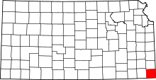
 KDOT map of Cherokee County (legend) | |
 Riverton Location within the state of Kansas | |
| Coordinates: 37°04′30″N 94°42′17″W / 37.07500°N 94.70472°WCoordinates: 37°04′30″N 94°42′17″W / 37.07500°N 94.70472°W | |
| Country |
|
| State |
|
| County | Cherokee |
| Area | |
| • Total | 2.30 sq mi (5.95 km2) |
| • Land | 2.24 sq mi (5.81 km2) |
| • Water | 0.05 sq mi (0.14 km2) |
| Elevation | 833 ft (254 m) |
| Population (2010)[1] | |
| • Total | 929 |
| • Density | 414/sq mi (159.8/km2) |
| Time zone | Central (CST) (UTC-6) |
| • Summer (DST) | CDT (UTC-5) |
| Area code(s) | 620 |
| FIPS code | 20-60200 [2] |
| GNIS feature ID | 0469345 [2] |
Riverton is an unincorporated community and census-designated place in Cherokee County, Kansas, United States. It is located at the junction of K-66 (former U.S. Route 66) and U.S. Route 69 Alternate and U.S. Route 400, near the Spring River. It is one of only three towns in Kansas along former U.S. Route 66. As of the 2010 census, the CDP population was 929.[1]
History
The first post office in Riverton was established in 1919.[3]
Geography
Riverton is located in southeastern Cherokee County near the southeastern corner of Kansas. Along K-66, Galena, Kansas, is 3.5 miles (5.6 km) to the east, and Joplin, Missouri, is 10 miles (16 km) to the east. Pittsburg, Kansas, is 23 miles (37 km) to the north via US 400 and US 69. Baxter Springs, Kansas, is 4.5 miles (7.2 km) to the southwest, and Miami, Oklahoma, is 20 miles (32 km) to the southwest by US 69A.
The eastern and southern edges of the CDP ars formed by the Spring River, which flows south to the Neosho River in Oklahoma. The CDP of Lowell is to the south across the Spring River.
Area attractions
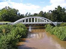
The famous Rainbow Bridge, about 2 miles (3 km) west of town, was the site where in the year 2000, musician Brad Paisley performed the song "(Get Your Kicks on) Route 66" for the TLC special "Route 66: Main Street America".
The Eisler Brothers Country Store in Riverton was one of the stops on Pixar's US 66 research trips for the 2006 film Cars. The filmmakers met with Dean Walker, then president of the Kansas Route 66 Association, who is known to twist his feet backwards 180° and walk in reverse. He became one of many inspirations for the Mater character, a rusty old tow truck who teaches NASCAR rookie Lightning McQueen to drive in reverse.[4]
"As luck would have it, we had just eaten a sandwich at the Eisler Brothers when we met Dean, He was proud as punch to show them his exorcist feet and regale them with stories of the Ghost Light."— Michael Wallis[4]
The original boom truck is currently based at a restored Kan-O-Tex Service Station in nearby Galena.
Gallery
-

Famous Eisler Brothers Country Store in Riverton, mentioned in the credits for the movie Cars
-

Rainbow Bridge near Riverton, 2008
See also
References
- 1 2 "Geographic Identifiers: 2010 Demographic Profile Data (G001): Riverton CDP, Kansas". U.S. Census Bureau, American Factfinder. Retrieved August 4, 2014.
- 1 2 "US Board on Geographic Names". United States Geological Survey. 2007-10-25. Retrieved 2008-01-31.
- ↑ "Kansas Post Offices, 1828-1961, page 2". Kansas Historical Society. Retrieved 6 June 2014.
- 1 2 Scott Meeker (June 10, 2006). "Riverton man inspired 'Cars' character". Joplin Globe.
Further reading
- County
- History of Cherokee County, Kansas; Nathanial Allison; Biographical Publishing; 646 pages; 1904. (Download 31MB PDF eBook)
- Kansas
- History of the State of Kansas; William G. Cutler; A.T. Andreas Publisher; 1883. (Online HTML eBook)
- Kansas : A Cyclopedia of State History, Embracing Events, Institutions, Industries, Counties, Cities, Towns, Prominent Persons, Etc; 3 Volumes; Frank W. Blackmar; Standard Publishing Co; 944 / 955 / 824 pages; 1912. (Volume1 - Download 54MB PDF eBook),(Volume2 - Download 53MB PDF eBook), (Volume3 - Download 33MB PDF eBook)
External links
- USD 404, local school district
- Cherokee County Map, KDOT
| |||||||||||||||||||||||||||||||||
