Richmond Hill, Queens

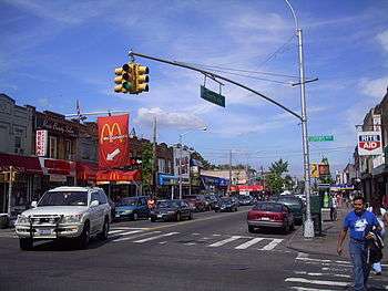
Richmond Hill is a racially and culturally integrated urban neighborhood in southwestern Queens County, a borough of New York City. It abuts Kew Gardens (North), Jamaica (East), Ozone and South Ozone Park (South), and Woodhaven (West). The neighborhood is split between Queens Community Board 9 and 10.[1] Main commercial streets in the neighborhood include Jamaica Avenue, Atlantic Avenue and Liberty Avenue; Richmond Hill is home to a density of Christian churches (both major denominations and storefront), Sikh centers, Hindu temples, Jewish synagogues and mosques.
Richmond Hill is known as Little Guyana, for its large Guyanese immigrant population, as well as Little Punjab, for its large Punjabi immigrant population; however, its demographics as of the 2010 Census are 30% Hispanic, 28% Asian, 23% White and 15% Black.
Many residents own their own homes, and some rent out apartments in them. There are also some small apartment buildings. Commercial strips along Jamaica and Liberty Avenue contain mixed use buildings. Atlantic Avenue is commercial. A Long Island Railroad spur and yard provides freight access for business at Jamaica Avenue and Lefferts Blvd. The US Postal Zip Code for Richmond Hill is 11418.
History

The hill referred to as Richmond Hill is a moraine created by debris and rocks collected while glaciers advanced down North America. Later, the Battle of Long Island, one of the bloodiest battles of the Revolutionary War, was fought in 1776 along the ridge now in Forest Park, near what is now the golf course clubhouse. Protected by its thickly wooded area, American riflemen used guerrilla warfare tactics to attack and defeat the advancing Hessians.
Richmond Hill's name was inspired either by a suburban town near London, England or by Edward Richmond, a landscape architect in the mid-19th century who designed much of the neighborhood. In 1868, a successful lawyer[2] named Albon P. Man bought the Lefferts and Welling farms, and hired Richmond to lay out the community. Streets, schools, a church, and a railroad were built over the next decade, thus making the area one of the earliest residential communities on Long Island. The area is well known for its large-frame single-family houses, many of which have been preserved since the turn of the 20th century. Many of the Queen Anne Victorian homes of old Richmond Hill still stand in the area today. The area first became developed in the later decades of the 19th Century with the 1868 opening of the Richmond Hill railroad station at the intersection of Hillside Avenue and Babbage Street, on the Montauk railroad line between Long Island City and eastern Long Island.
The area received further development in 1918, when the BMT Jamaica Line of the New York City Subway (now the J Z trains) was extended in the neighborhood. It also contains a southern terminal of the A trains, which heads toward Lefferts Boulevard / Liberty Avenue on the IND Fulton Street Line, along with MTA Regional Buses Q10 bus line from Kew Gardens IND Subway Station to JFK Airport.
Landmarks
The Triangle Hofbrau[3] was a restaurant which was frequented by such stars as Mae West in the 1920s and 1930s. It sat on the triangular piece of land bordered by Hillside Avenue, Jamaica Avenue, and Myrtle Avenue.
Near the northwest corner of Hillside Avenue and Myrtle Avenue sat an old time ice cream parlor, Jahn's. It closed in late 2007. Not far away is Lefferts Boulevard which, with Liberty Avenue, define the central core of Richmond Hill. Between Myrtle Avenue and the Montauk Line railroad is a former movie theatre, RKO Keith's Richmond Hill Theater, opened in 1929, functioning since 1968 as a bingo hall.[4]
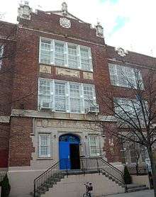
The northern edge of Richmond Hill contains the Church of the Resurrection. This Episcopalian church is an 1874 structure and is the oldest house of worship in Richmond Hill. It was placed in the National Register of Historic Places in 2003.[5] Also listed on the National Register of Historic Places are Public School 66 and Saint Benedict Joseph Labre Parish.[6]
Demographics
Originally, many European families (Italian, Dutch, British, Irish, Scots, Danish, and German) lived in Richmond Hill. Today, the south side of Richmond Hill consists mostly of South Asian Americans (Indians and Bangladeshis) and Caribbean Americans (Trinidadians, Guyanese, and Jamaicans), who have steadily emigrated to the United States since the 1970s. [7]Richmond Hill also has the largest Sikh population in the city.[8]
Media
WICR, 1620AM, broadcasts Indo-Caribbean programming from studios on Liberty Avenue in South Richmond Hill.
Parks
Education
Libraries
Schools


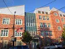
Richmond Hill schools are operated by the New York City Department of Education.
Public schools include:
- P.S. 51
- P.S. 161 Arthur R. Ashe Junior School
- P.S. 54 Hillside Avenue School
- P.S. 55 The Maure School
- P.S. 56 Harry Eichler School
- P.S. 62 Chester Park School
- P.S. 66 Oxford School
- P.S. 90 Horace Mann School
Residents are zoned to M.S. 137 America's School of Heroes.
Richmond Hill High School is located in the neighborhood. Until June, 2012, the city had planned to close the high school. The city had slated the school to close; however, a court ruling prevented the school's closure.[9][10]
Private schools include:
- Bethlehem Christian Academy
- Hebrew Academy-West Queens
- Holy Child Jesus Academy Holy Child Jesus School
- Islamic Elementary School
- Theatre Street School
Notable residents
- Amelia Edith Huddleston Barr (1831-1919) – Author of the book Jan Vedder's Wife and an advocate of women's rights.
- Gary Barnett Entrepreneur and Philanthropist President and Founder of Extell Development Company
- Jack Cassidy – Broadway and television actor was born and raised in Richmond Hill.
- Percy Crosby – Creator of the comic Skippy.
- Rodney Dangerfield – Famous comedian who attended Richmond Hill High School.
- Morton Gould – Winner of a Pulitzer Prize, Kennedy Center Honor, and a Grammy Award.[11]
- Alfred H. Grebe – Pioneer in radio broadcasting.
- Anaïs Nin – French-Cuban author of The Delta of Venus and diarist. Lived in Richmond Hill prior to moving to Paris in 1924.
- Jack Kerouac – Lived in Richmond Hill from 1950-55.[12]
- Jack Lord – Actor famous for portraying Lt. Steve McGarrett on Hawaii Five-O.
- Jack Maple – Former deputy commissioner of New York City Police Department that inspired the television series The District.[13]
- Marx Brothers – Family comedy act, whose house is still noted with a commemorating plaque.
- John H. Myers – Former CEO of GE Asset Management (childhood residence).
- Jacob A. Riis – Documentary journalist/author, photographer and reformer was a Richmond Hill resident.
- Phil Rizzuto – Hall of Fame Baseball Player who lived and went to high school in Richmond Hill.
- Bob Sheppard – Yankee Stadium Public Address Announcer "The Voice of the Yankees" from 1951 - 2009 was born and raised in Richmond Hill.
- Dick Van Patten – Actor, raised in Richmond Hill.
References
- ↑ Queens Community Boards, New York City. Accessed September 3, 2007.
- ↑ The Richmond Hill Chapter of The Queens Historical Society. "Victorian Richmond Hill". http://www.richmondhillhistory.org/man.html. External link in
|website=(help); - ↑ http://www.richmondhillhistory.org/Hofbrau.html
- ↑ http://cinematreasures.org/theater/3972/
- ↑ Richmond Hill Historical Society, "About the Church of the Resurrection: First Church erected in Richmond Hill." http://www.richmondhillhistory.org/Resurrection.shtml
- ↑ Staff (2010-07-09). "National Register Information System". National Register of Historic Places. National Park Service.
- ↑ "New York City's Newest Immigrant Enclaves".
- ↑ http://www.queensny.org/qedc/neighborhoods/economy/reports_profiles/Richmond_Hill_Neighborhood_Profile_ed.pdf
- ↑
- ↑ "New names selected for schools expected to close, reopen in the fall", Daily News (New York).
- ↑ Morton Gould
- ↑ http://www.richmondhillhistory.org/jkerouac.htm
- ↑ Jack Maple
External links
| Wikimedia Commons has media related to Richmond Hill, Queens. |
Official government websites:
Historical societies:
- Friends of the Richmond Hill Library
- Richmond Hill Block Association
- Richmond Hill Historical Society
- Richmond Hill Local News
- Queens Historical Society
Coordinates: 40°41′44.84″N 73°49′37.89″W / 40.6957889°N 73.8271917°W
