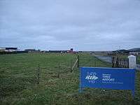
Tiree Airport
"eGPU" redirects here. For the electronic circuit, see External GPU.
| Tiree Airport Port-adhair Thirioah | |||||||||||||||||||
|---|---|---|---|---|---|---|---|---|---|---|---|---|---|---|---|---|---|---|---|
|
Tiree Airport | |||||||||||||||||||
| IATA: TRE – ICAO: EGPU | |||||||||||||||||||
| Summary | |||||||||||||||||||
| Airport type | Public | ||||||||||||||||||
| Operator | Highlands and Islands Airports Limited | ||||||||||||||||||
| Location | Balemartine, Argyll and Bute | ||||||||||||||||||
| Elevation AMSL | 38 ft / 12 m | ||||||||||||||||||
| Coordinates | 56°29′57″N 006°52′09″W / 56.49917°N 6.86917°WCoordinates: 56°29′57″N 006°52′09″W / 56.49917°N 6.86917°W | ||||||||||||||||||
| Website |
www | ||||||||||||||||||
| Map | |||||||||||||||||||
 EGPU Location in Argyll and Bute | |||||||||||||||||||
| Runways | |||||||||||||||||||
| |||||||||||||||||||
Tiree Airport (Scottish Gaelic: Port-adhair Thiriodh) (IATA: TRE, ICAO: EGPU) is located 2.5 nautical miles (4.6 km; 2.9 mi) north northeast of Balemartine on the island of Tiree in the Inner Hebrides off the west coast of Scotland. It is owned and maintained by Highlands and Islands Airports Limited.
The airport is served by a scheduled service from Glasgow, operated by a Loganair Twin Otter.
History
The airfield is the former Royal Air Force Station Tiree which was requisitioned in 1940 and became operational in April 1942 before being transferred to Ministry of Civil Aviation in 1947.[2]
The following units were based at RAF Tiree at some point:
- No. 224 Squadron RAF.[3]
- No. 281 Squadron RAF.[4]
- No. 304 Squadron RAF.[5]
- No. 518 Squadron RAF.[6]
- 819 Naval Air Squadron.[7]
- 845 Naval Air Squadron.[7]
- 1840 Naval Air Squadron.[7]
Airlines and destinations
| Airlines | Destinations |
|---|---|
| Flybe operated by Loganair | Glasgow-International |
| Hebridean Air Services | Oban, Coll |
References
Citations
- ↑ Tiree - EGPU
- ↑ "RAF Tiree airfield". Control Towers. Retrieved 26 July 2012.
- ↑ Jefford 1988, p. 73.
- ↑ Jefford 1988, p. 83.
- ↑ Jefford 1988, p. 85.
- ↑ Jefford 1988, p. 95.
- 1 2 3 "Tiree (Reef)". Airfields of Britain Conservation Trust. Retrieved 18 October 2013.
Bibliography
- Jefford, C.G, MBE, BA, RAF (Retd). RAF Squadrons, a Comprehensive Record of the Movement and Equipment of all RAF Squadrons and their Antecedents since 1912. Shrewsbury, Shropshire, UK: Airlife Publishing, 1988. ISBN 1-84037-141-2.
External links
- Map sources for Tiree Airport
| ||||||||||
| ||||||||||||||||||||||||||||||||||||||||||||||||||||||||||||
This article is issued from Wikipedia - version of the Saturday, July 04, 2015. The text is available under the Creative Commons Attribution/Share Alike but additional terms may apply for the media files.
