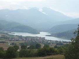
Potamoi, Drama
| Potamoi Ποταμοί | |
|---|---|
|
The village of Potamoi | |
 Potamoi | |
| Coordinates: 41°23′N 24°06′E / 41.383°N 24.100°ECoordinates: 41°23′N 24°06′E / 41.383°N 24.100°E | |
| Country | Greece |
| Administrative region | East Macedonia and Thrace |
| Regional unit | Drama |
| Municipality | Kato Nevrokopi |
| Elevation | 445 m (1,460 ft) |
| Population (2001)[1] | |
| • Rural | 413 |
| Community | |
| Time zone | EET (UTC+2) |
| • Summer (DST) | EEST (UTC+3) |
| Postal code | 66033 |
| Area code(s) | 2523 |
| Vehicle registration | ΡΜ |
Potamoi (Greek: Ποταμοί), until 1927 known as Borovo (Greek: Μπόροβον, Bulgarian: Борово),[2] is a village in the Drama regional unit, Greece. It is situated in the Chech region, at the mouth of the river Dospat on the left shore of the river Nestos.
History
Human habitation in the area of the village stretches back to prehistory. In 1967 many artifacts from different epochs were found near the village with some dated to the Bronze Age.[3] Further 860 silver coins from Philip II of Macedon have been excavated from the environs of the village.[4]
The village is first mentioned as Borovo in an Ottoman registry from the latter 15th/early 16th century, with 153 registered [male] inhabitants.[5] The village has also been mentioned (as Borova) by the Austrian geologist Ami Boué, who visited the Balkans between 1836-1838. He notes that the way from Dospat to Kato Nevrokopi goes through Borova. He further notes that the village has been visited earlier by the Frenchman Vikenel.[6]

According to the Bulgarian ethnographer Vasil Kanchov, as of the 19th century the village of Borovo was a Muslim-populated village with 500 Bulgarian Muslims (Pomaks), 250 Turks and 140 houses.[7][8] In another statistic from 1873 the village of Borovo is mentioned as a Pomak village with 280 male Pomaks and 110 households.[9] According to a Greek statistic from 1913 Borovo (Μπόροβον) is a village with 1045 inhabitants.[10]
Kanchov writes that in 1900 the village was ruled by a mudur with no power outside of it. He also notes the existence of two mosques and a maktab.[11]
In 1923 the Pomaks and the Turks were expelled from the village according to the Treaty of Lausanne. Subsequently Greek refugees from Turkey were settled in the village. In 1928 the number of the refugees settled in Borovo had reached 384 and the number of the Greek families 113.[12] In 1927 the name of the village was changed from Borovo (Μπόροβο) to Potami (Ποταμοί).[13]
During World War II and after the Bulgarian coup d'état of 1944, a group of Pomak soldiers led by Faik Gaziev from the Bulgarian village of Ablanitsa sponsored by the USA and Greece carried out sabotage and reconnaissance missions against the Communists regime in Bulgaria from the village of Potamoi.[14]
According to Greek data the population of Potamoi has changed as follows: 1920 - 650 inhabitants, 1928 - 438 inhabitants, 1940 - 873 inhabitants, 1951 - 760 inhabitants, 1961 - 751 inhabitants, 1971 - 537 inhabitants, 1981 - 397 inhabitants, 1991 - 377 inhabitants, 2001 - 413 inhabitants.[3]
References
- ↑ De Facto Population of Greece Population and Housing Census of March 18th, 2001 (PDF 39 MB). National Statistical Service of Greece. 2003.
- ↑ "Borovo -- Potamoi" (in Greek and English). Pandektis. Retrieved 2009-12-06.
- 1 2 Pathfinder clubs. "ΟΔΟΙΠΟΡΙΚΟ ΣΤΟ ΝΟΜΟ ΔΡΑΜΑΣ". Retrieved 2009-05-03.
- ↑ "Γενικό ιστορικό περίγραμμα της περιοχής της Δράμας και του σημερινού Δήμου Δοξάτου". Δήμος Δοξάτου. Retrieved 2009-05-04.
- ↑ Гандев, Христо (1989) [1972]. "Населени места с регистрирани имена на главите на домакинствата (XV-XVI в.)". Българската народност през XV век: Демографско и етнографско изследване (in Bulgarian) (II ed.). София: Наука и Изкуство.
- ↑ Цветкова, Бистра (1981). "Родопите или Деспото-Даг и техните пътища". Френски пътеписи за Балканите, XIX в. (in Bulgarian). София: Наука и изкуство. p. 328.
- ↑ Кънчов, Васил (1996) [1900]. "Неврокопска Каза". Македония. Етнография и статистика (in Bulgarian) (II ed.). София: Проф. М. Дринов. p. 196.
- ↑ Кънчов, Васил (1970) [1894-1896]. "Пътуване по долините на Струма, Места и Брегалница. Битолско, Преспа и Охридско". Избрани произведения. Том I (in Bulgarian). София: Наука и изкуство. p. 269.
- ↑ Македония и Одринско. Статистика на населението от 1873 г. (in Bulgarian, French, English, and Russian) (II ed.). София: Македонски научен институт. 1995 [1878]. pp. 130–131.
- ↑ Λιθοξόου, Δημήτρης. "Απαρίθμηση των κατοίκων των νέων επαρχιών της Ελλάδος του έτους 1913 - Μακεδονία". Retrieved 2009-05-03.
- ↑ Кънчов, Васил (1970) [1894-1896]. "Пътуване по долините на Струма, Места и Брегалница. Битолско, Преспа и Охридско". Избрани произведения. Том I (in Bulgarian). София: Наука и изкуство. p. 268.
- ↑ Λιθοξόου, Δημήτρης. "Κατάλογος των προσφυγικών συνοικισμών της Μακεδονίας σύμφωνα με τα στοιχεία της Επιτροπής Αποκαταστάσεως Προσφύγων (ΕΑΠ) έτος 1928". Retrieved 2009-12-06.
- ↑ Λιθοξόου, Δημήτρης. "Μετονομασίες των οικισμών της Μακεδονίας 1919 - 1971". Retrieved 2009-12-06.
- ↑ Имам, Ибрахим; Конедарева, Сенем (2008). Абланица през вековете (in Bulgarian). Благоевград: Бон. pp. 64–65. ISBN 978-954-395-004-1.
External links
![]() Media related to Potamoí at Wikimedia Commons
Media related to Potamoí at Wikimedia Commons
| ||||||
