Possession Islands
For other uses, see Possession Island.
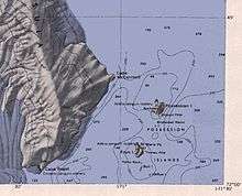
 Map of Possession Islands. | |
| Geography | |
|---|---|
| Location | Antarctica |
| Coordinates | 71°52′S 171°12′E / 71.867°S 171.200°E.[1] |
| Country | |
| Demographics | |
| Population | 0 |
| Additional information | |
| Administered under the Antarctic Treaty System | |
The Possession Islands are a group of small islands and rocks extending over an area of about 7 miles (11 km), lying in the western part of the Ross Sea, 5 miles (8 km) southeast of Cape McCormick, Victoria Land. The Possession Islands were named by Captain James Clark Ross, Royal Navy, in commemoration of the planting of the British flag here on January 12, 1841.[2]
Coordinates: 71°56′S 171°10′E / 71.933°S 171.167°E[2]
Possession Island
Possession Island is a rocky island nearly 2 miles (3.2 km) long, which is the northernmost and largest of the Possession Islands. Possession Island is located at 71°52′S 171°12′E / 71.867°S 171.200°E.[1] Archer Peak is a peak on the southernmost edge of Possession Island.
See also
- Composite Antarctic Gazetteer
- List of Antarctic and sub-Antarctic islands
- List of Antarctic islands south of 60° S
- SCAR
- Territorial claims in Antarctica
References
- 1 2 "Possession Island". Geographic Names Information System. United States Geological Survey. Retrieved 2009-12-24.
- 1 2 "Possession Islands". Geographic Names Information System. United States Geological Survey. Retrieved 2009-12-14.
External links
This article is issued from Wikipedia - version of the Saturday, November 21, 2015. The text is available under the Creative Commons Attribution/Share Alike but additional terms may apply for the media files.