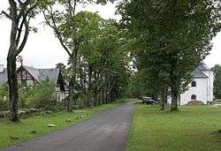
Pohoří na Šumavě
| Pohoří na Šumavě | |
|---|---|
| Village | |
 | |
 Pohoří na Šumavě | |
| Coordinates: 48°36′14″N 14°41′47″E / 48.60389°N 14.69639°ECoordinates: 48°36′14″N 14°41′47″E / 48.60389°N 14.69639°E | |
| Country |
|
| Region | South Bohemian |
| District | Český Krumlov |
| Area | |
| • Total | 26.376 km2 (10.184 sq mi) |
| Elevation | 910 m (2,990 ft) |
| Population (2014) | |
| • Total | 2 |
| • Density | 0.076/km2 (0.20/sq mi) |
| Postal code | 382 83 |
Pohoří na Šumavě (German: Buchers, Bucherwald, Buchers bei Kaplitz, Buchers im Böhmerwald, Czech: Puchéř, Buchoř (1869–1910) or Půchoří) is a former village and municipality (obec) in Český Krumlov District in the South Bohemian Region of the Czech Republic. The settlement has been abandoned since the 1970s but now is being restored step by step. The village was named Pohoří na Šumavě in 1923 and nowadays is part of the municipality of Pohorská Ves.
Pohoří na Šumavě lies approximately 35 kilometres (22 mi) south-east of Český Krumlov, 43 km (27 mi) south of České Budějovice, and 165 km (103 mi) south of Prague.
Nature protection
There are some small protected natural areas in the cadastre of Pohoří na Šumavě:
- Myslivna
- Pohořské rašeliniště
- Prameniště Pohořského potoka
- Stodůlecký vrch
- U tří můstků
References
| Wikimedia Commons has media related to Pohoří na Šumavě. |
This article is issued from Wikipedia - version of the Saturday, November 28, 2015. The text is available under the Creative Commons Attribution/Share Alike but additional terms may apply for the media files.