Podwale Street in Bydgoszcz
| Bydgoszcz | |
|---|---|
| Ulica podwale w Bydgoszczy | |
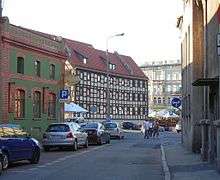 View of the street | |
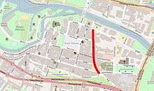 Location of Podwale Street in Bydgoszcz | |
| Part of | Bydgoszcz Old town district |
| Namesake | Under the rampart (pod-wał) |
| Owner | City of Bydgoszcz |
| Length | 230 m (750 ft) |
| Location | Bydgoszcz |
| Wikimedia Commons has media related to Podwale Street in Bydgoszcz. |
Podwale street is a historic path of Bydgoszcz old town.
Location
The street is located in the eastern part of the Old Town. It extends approximately on a north-south axis, from the Grodzka Street to Długa Street. It is approximately 230m long.
Naming
The street section has born the following names:[1]
- 16th to the first half of 18th centuries - "Platea dicta Frog", "Wałowa" ("Embankment")
- 1800-1920 - Wallstraße
- 1920-1939 - Podwale
- 1939-1945 - Wallstraße
- From 1945 - Podwale
The name refers to the alleged fortification, Polish: wał, "rampart", located on the east side of the street, along the castle moat, part of fortifications of the city.
History
Podwale Street was laid out in the middle of the 14th century, during the formation of the old town of Bydgoszcz. It was following the moat of the castle, on the eastern edge of the city: in fact, it marks the delineation between the ancient city charter and the early medieval castle. At this place, the king Casimir III the Great approved, mid-14th century, the construction of the Starostwo Castle.
During the archaeological searches out in the area Podwale street (at the intersection with Grodzka street), at 1.2 to 2m deep, have been found medieval wooden buildings with ceramics dating back to the end of the 14th century - beginning of the 15th century.[2] Remains of wooden structures have been also discovered, from a post-16th century palisade.

Podwale Street acted as a transit route, which led to the trade route from Gdańsk and Świecie towards Inowrocław and southward). In the city, this trading road started at the "Gate of Gdansk" to the north, through the bridge over the Brda river and ended at the "Kujawska Gate" to the south.[3]
Due to its location along the castle wall on eastern side, first buildings in Podwale street appeared only on its western side: on the other frontage, historians have localized a fortification erected here in the second half of the 17th century.[4] However, other archaeological research performed in 2005 at Podwale 15 showed there was no rampart at this point,[3] but rather a castle moat, which has not been stabilized with the rhythm of flooding of the river. It was set in the 15th century thanks to the creation of the first wooden structures. The moat, in the 14th century was gradually inundated; with such a large, natural wide trench there was no need to build additional defenses.
The first records of houses and breweries in Podwale street date back to 1560. In the 1640s, 1650s and 1660s several brick buildings started to appear. After the takeover of the city by Prussia in 1772, the street name was changed to Wałowa.[3]
On a detailed plan of Bromberg drawn by the Prussian geometer Gretha in 1774, the western side of the street shows few empty plots located in the area of Długa street, Zaułek Street and in the corner of Grodzka street, whereas the eastern side displays very few buildings standing only in the corners of the Grodzka street and at Kujawska Gate. In 1787, at the crossing with Magdzińskiego street, was built the former evangelical parish church, and in 1809 the first buildings in the southern part of Podwale (present N°11 to 15) have been erected. By the mid XVIIth century, Podwale street displayed an entire frontage of houses. In 1899, extensive work started, aimed at getting rid of the former castle hill, lying on the east side of Podwale street:
- the evangelical parish church was demolished,
- the city Market Hall was erected (1904)
- Magdzińskiego street was extended eastward.[1]
Podwale street, thus shaped at the beginning of the 20th century, did not change for decades that came. In 2010, the street has been included in the Revitalization Plan of downtown Bydgoszcz.[5]
Architecture
Frontages in Podwale street mostly date from the end of 18th century to the start of the 20th century. Among them is the iconic Municipal Market Hall built in 1904. The building has kept its same function unchanged till today.
Main places and buildings
Municipal Market Hall
Kuyavian-Pomeranian Heritage list N°601393, Reg.A/971 (April 11, 1971).[6]
Podwale St. N°4
1904[7]
The eastern side of the present Market Hall stands on what was until the 18th century the moat of the castle of Bydgoszcz, parting the Old Town and the fortified edifice of the Starostwo. At the end of the 18th century, the moat, useless, had gradually silted up, leveling with the area around. In 1787, Prussian authorities constructed in its place a parish evangelical church, the first non-Catholic church in the city. This church served the Evangelical urban communities throughout the 19th century.
In 1899, an intensive work has been carried out to clean the site of the former castle hill, lying on the east side of Podwale street, demolishing the evangelical church. On the other hand, a few years later, in 1904, the Municipal Market Hall was erected and extended eastward, on Magdzińskiego street.[1] The building has been designed by the company "Boswau & Knauer GmbH" from Berlin.[8] It was built at a time when society was starting to take matters related to health and hygiene into consideration: hence the roofed hall to maintain hygiene standards in the food trade. The city of Bydgoszcz was the main investor of the project. In addition to the plot of the Evangelical church, part of neighbouring property of rentier Albert Wiese was used. The construction started in autumn 1904 and ended in the spring 1906: the official opening took place on Friday 20 July 1906, in the presence of municipal authorities.[8] Part of the Market Hall giving onto Podwale street housed accommodations, such as the apartment of the inspector of the Hall, veterinarian offices or a police station. Under the main hall was room for 96 stands, the vast majority of them being meat stands. Each stand (meat and fish) has been provided with a separate number and company name. The building is still equipped with a 3.5 m high cellars, and at its opening was open on all days of the week. The end and beginning of trade was proclaimed the ring of a bell.[8] While inside the Hall only meat (including fish and sea products) was sold, other goods could be bought at the weekly fairs held in the open squares.[8] Today the complex is open to all kind of trade, under the ownership of Bydgoszcz's grocers ((Polish). In 2009, a full renovation of the building has been carried out.
The Market Hall has a rectangular shape and is covered with glass-steel panes, the facades are made of brick.[9] Above the main entrance gate stands the crest of Bydgoszcz.
The ensemble combines Neo-Gothic elements with modernist features:
- the south-east corner is a tower topped with a tented roof;
- the south-west corner is beveled, the summit is crenelated stepped, with a large semi-circular door opening;
- the south elevation and eastern elevaitons have large, semicircular topped windows, with tracery;
- the western elevation on Podwale street is different, with storeys and covered with a pitched roof.[9]
-
Main Gate View
-

Corner tower with high glass windows
-
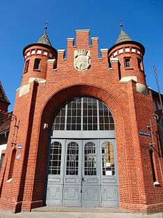
Main gate detail
-

Bydgoszcz crest
-

Rear of the Market Hall

House at N°11
Kuyavian-Pomeranian Heritage list N°711447, Reg.A/1355/1-3 (February 27, 2008).[6]
Podwale St. N°11
1782
Townhouse located opposite Zaułek street, rebuilt in 1879.[7]
-

Main elevation
-
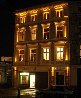
By night
House at N°13
Kuyavian-Pomeranian Heritage list N°787206, Reg.A/1623 (January 7, 2013).[6]
Podwale St. N°13
1875-1900[7]
Wells are located in the basement of the building, from which residents formerly drew water.[10] The fontage has undergone a deep renovation in 2014, including the reconstruction of balconies.[11]
-
Main elevation before overhaul.
-
House at Podwale 13 after renovation
House at N°15
Podwale St. N°15
18th century
This corner house has been rebuilt in 1883[7] on design by Joseph Święcicki. At the beginning of the 19th century, in an adjacent building was located the municipal police station.[1]
-
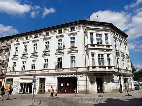
Main elevation.
-
Facade on Podwale street
-

Detail of the bay-window
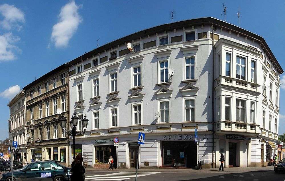
House at Kręta street N°3
Corner with Podwale street
Second half of 19th century[7]
Former warehouse and industrial building on the corner with Kręta street, it now houses, among others, the "Eljazz music club".
-

Main elevation.
-

By night.
Bydgoszcz Chamber theatre
Kuyavian-Pomeranian Heritage list N°601341, Reg.A/887, June 21, 1993.[6]
Grodzka St.14-16
House on the corner with Grodzka Street which housed the Bydgoszcz Chamber theatre between 1961 and 1989, the second dramatic stage theater of the city.
-

View from the Brda river
See also
- Gdańska Street, Bydgoszcz
- Grodzka Street in Bydgoszcz
- Theatre square in Bydgoszcz
- Jagiellońska street in Bydgoszcz
- Stary Port Street in Bydgoszcz
References
- 1 2 3 4 Czachorowski Antoni red.: Atlas historyczny miast polskich. Tom II Kujawy. Zeszyt I Bydgoszcz. Uniwersytet Mikołaja Kopernika. Toruń 1997
- ↑ Dygaszewicz Elżbieta: Bydgoszcz przedlokacyjna i lokacyjna w świetle nadzorów i archeologicznych badań ratowniczych. [w.] Materiały do Dziejów Kultury i Sztuki Bydgoszczy i Regionu. zeszyt 1. Pracownia Dokumentacji i Popularyzacji Zabytków Wojewódzkiego Ośrodka Kultury w Bydgoszczy. 1996
- 1 2 3 Siwiak Wojciech, Siwiak Anna: Wschodnie „umocnienia" obronne Bydgoszczy w świetle badań archeologicznych ulicy Podwale. [w.] Kronika Bydgoska XXXIX 2007. Bydgoszcz 2008
- ↑ Grochowski Robert. Bramy, wały i fortyfikacje bastionowe dawnej Bydgoszczy. Kronika Bydgoska XXIII (2001). Bydgoszcz 2002
- ↑ http://www.pomorska.pl/apps/pbcs.dll/article?AID=/20100616/BYDGOSZCZ01/429392914 dostęp 30-09-2010
- 1 2 3 4 Załącznik do uchwały Nr XXXIV/601/13 Sejmiku Województwa Kujawsko-Pomorskiego z dnia 20 maja 2013 r.
- 1 2 3 4 5 6 Gminna Ewidencja Zabytków Miasta Bydgoszczy. [w:] Program Opieki nad Zabytkami miasta Bydgoszczy na lata 2013-2016
- 1 2 3 4 Garbaczewski Witold: Stuletnia hala targowa. [w.] Kalendarz Bydgoski 2007
- 1 2 Parucka Krystyna. Zabytki Bydgoszczy – minikatalog. „Tifen” Krystyna Parucka. Bydgoszcz 2008
- ↑ Katarzyna Idczak "Wiosna starych murów", Express Bydgoski 2 lipca 2012
- ↑ Te budynki wypiękniały w 2014 r. dzięki dotacji z ratusza
Bibliography
- (Polish) Derenda Jerzy red.: Piękna stara Bydgoszcz. Tom I z serii: Bydgoszcz miasto na Kujawach. Towarzystwo Miłośników Miasta Bydgoszczy. Bydgoszcz 2006. ISBN 83-916178-0-7, 978-83-916178-0-9, 83-916178-5-8, 978-83-916178-5-4, 83-916178-1-5, 978-83-916178-1-6
- (Polish) Umiński, Janusz: Bydgoszcz. Przewodnik, Regionalny Oddział PTTK „Szlak Brdy” Bydgoszcz 1996
- (Polish) Garbaczewski Witold: Stuletnia hala targowa. [w.] Kalendarz Bydgoski 2007
External links
Coordinates: 53°07′17″N 18°00′08″E / 53.1213°N 18.0021°E