Plumsteadville, Pennsylvania
| Plumsteadville, Pennsylvania | |
|---|---|
| Census-designated place | |
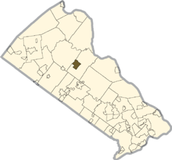
 Location of Plumsteadville in Bucks County | |
| Country | United States |
| State | Pennsylvania |
| County | Bucks |
| Township | Plumstead |
| Population (2010) | |
| • Total | 2,637 |
| Time zone | Eastern (EST) (UTC-5) |
| • Summer (DST) | EDT (UTC-4) |
| ZIP codes | 18949 |
| Area code(s) | 215 and 267 |
Plumsteadville is a census-designated place[1] in Plumstead Township, Bucks County, Pennsylvania. It is located along PA Route 611 about 8 miles north of Doylestown. As of the 2010 census, the population was 2,637 residents.[2]
Community
The local school district is Central Bucks and children attend Groveland Elementary School. Plumsteadville also has plenty of access to outdoor activities. These activities include a bike ride to Tinicum Park, rock climbing at High Rocks and hiking. Neighborhoods in the area are conducive to groups of children gathering for playtime activities.
References
Coordinates: 40°23′14″N 75°08′48″W / 40.38722°N 75.14667°W
This article is issued from Wikipedia - version of the Monday, January 11, 2016. The text is available under the Creative Commons Attribution/Share Alike but additional terms may apply for the media files.
