Pinepoca, West Virginia
| Pinepoca, West Virginia | |
|---|---|
| Former settlement | |
 Pinepoca, West Virginia | |
| Coordinates: 37°47′08″N 81°08′18″W / 37.78556°N 81.13833°WCoordinates: 37°47′08″N 81°08′18″W / 37.78556°N 81.13833°W | |
| Country | United States |
| State | West Virginia |
| County | Raleigh |
| Elevation | 1,827 ft (557 m) |
| GNIS feature ID | 1742902[1] |
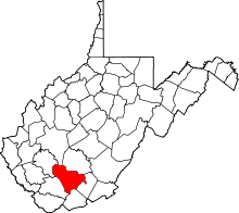
Pinepoca is a former settlement in Raleigh County, West Virginia, United States. Pinepoca was 3 miles (4.8 km) east-northeast of Beckley. Pinepoca appeared on USGS maps as late as 1929.
References
- ↑ "US Board on Geographic Names". United States Geological Survey. 2007-10-25. Retrieved 2008-01-31.
This article is issued from Wikipedia - version of the Wednesday, July 30, 2014. The text is available under the Creative Commons Attribution/Share Alike but additional terms may apply for the media files.
