Phidim
| Phidim Municipality फिदिम नगरपालिका | |
|---|---|
| Municipality | |
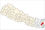
 Phidim Municipality Location in Nepal | |
| Coordinates: NP 27°08′46″N 87°45′58″E / 27.146°N 87.766°ECoordinates: NP 27°08′46″N 87°45′58″E / 27.146°N 87.766°E | |
| Country |
|
| Zone | Mechi Zone |
| District | Panchthar District |
| Population (2001) | |
| • Total | 13,652 |
| Time zone | Nepal Time (UTC+5:45) |
| Postal code | 57400 |
| Area code(s) | 024 |
| Website | www.phidimmun.gov.np |
Phidim Municipality is the headquarters of the Panchthar District in the Mechi Zone of eastern Nepal. Phidim was transformed into municipality from village development committee merging with other vdcs i.e. Phidim, Chokmagu and Siwa villages on 18 May 2014.[1][2] It serves as a major route for trekkers and common people who travel to and from the Taplejung district bordering with the Tibetan Autonomous Region of China. It is also a commercial hub for the rural people of the district.
Transportation
Phidim is connected to rest of the country through Mechi Highway, a 262.7 km road which begins in Charali of Mahendra Highway in Jhapa district and ends in Phungling, the headquarters of Taplejung district. Passenger buses and jeeps to Phidim are easily available in Birtamod and Ilam. Phidim also provides good hotels and inns for accommodation and food. Also there is a new connection with the Sakranti VDC of Terhathum district by a gravel road through which it is linked to Koshi Highway in Myanglung Bazar (Headquarter of Terhathum District). Now, Madhya Pahadi Rajmargha one of the road linking east to west of Nepal through hilly areas gets started from Panchthar district and gets connection with Phidim.
Geography
Phidim is a picturesque valley in the foothills of Himalayas in eastern Nepal. It is a beautiful hill township. The landscape surrounding the place is unique and the scenic beauty is enchanting. Phidim is a six-hour drive from Birtamod through winding road via Ilam. The road trip is one of the most spectacular in Nepal. From Phidim, one can view the snow-capped Himalaya, verdant hills loom in the distance. Phidim has tin-roofed houses and small concrete buildings. Two rivers—Phewa and Hewa—embrace the hill, where the town is located.
Demography
At the time of the 2001 Nepal census it had a population of 13652 people.[3] The inhabitants are Magar, Limbu, Rai, Tamang, so-called Dalit, and Brahmin and Chhetris, Newar which makes it one of the most diverse places in eastern Nepal.
Climate
The climate of Phidim is mild during the summer and cold and misty in the winter. Maximum temperature in the summer goes up to 25 degree Celsius whereas in winter it lowers to 2 degree Celsius.
Agriculture and industry
Because of its fertile soil and good irrigation, Phidim produces rice, potato, cardamom and tea. Kanchenjunga Tea Estate, one of major producers of Nepal tea, has field office in Phidim.
Incidents
February 5, 2010: A fire that started from a hotel in Phidim killed three people. Property worth 2 million rupees was estimated to be damaged. It was reported that three dozen people were inside three hotels when it was caught by the fire, which was extinguished by local security forces.
Media
To Promote local culture, Phidim has three community radio station named as Radio Sumhatlung - 104.2 MHz, Eagle FM and Singhalila FM - 97.3 MHz.
Footnotes
Ekantipur: Phidim inferno: Death toll reaches three; police suspect more casualties (February 6, 2010) Retrieved July 3, 2012
References
- ↑ 72 new municipalities announced My Republica
- ↑ Govt announces 72 new municipalities The Kathmandu Post
- ↑ "Nepal Census 2001". Nepal's Village Development Committees. Digital Himalaya. Retrieved 12 December 2008.
External links
- Phidim Today, a news portal run by Phidimese youth
- The Kathmandu Post: The Ferment in the eastern hills
- How a peace corps volunteer boosted my morale
- Somewhere above Phidim
- Phidim in pictures
