Phelps City, Missouri
| Phelps City, Missouri | |
|---|---|
| Census-designated place & unincorporated community | |
 Phelps City | |
| Coordinates: 40°24′12″N 95°35′55″W / 40.40333°N 95.59861°WCoordinates: 40°24′12″N 95°35′55″W / 40.40333°N 95.59861°W | |
| Country | United States |
| State | Missouri |
| County | Atchison |
| Area[1] | |
| • Total | 0.493 sq mi (1.28 km2) |
| • Land | 0.493 sq mi (1.28 km2) |
| • Water | 0 sq mi (0 km2) |
| Elevation | 892 ft (272 m) |
| Population (2010)[2] | |
| • Total | 24 |
| • Density | 49/sq mi (19/km2) |
| Time zone | Central (CST) (UTC-6) |
| • Summer (DST) | CDT (UTC-5) |
| Area code(s) | 660 |
| GNIS feature ID | 724280[3] |
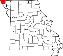
Phelps City is a census-designated place and unincorporated community in Atchison County, Missouri. As of the 2010 census, its population was 24.[2] The community is 5 miles (8.0 km) west of Rock Port.[3] It is the closest Missouri community to Brownville Bridge, a Missouri River crossing that is listed on the National Register of Historic Places.
History
Phelps City was laid out in 1868. It was named for Willis Phelps, one of the owners of the town site.[4]
References
- ↑ "US Gazetteer files: 2010, 2000, and 1990". United States Census Bureau. 2011-02-12. Retrieved 2011-04-23.
- 1 2 "American FactFinder". United States Census Bureau. Retrieved 2011-05-14.
- 1 2 "Phelps City". Geographic Names Information System. United States Geological Survey.
- ↑ Eaton, David Wolfe (1916). How Missouri Counties, Towns and Streams Were Named. The State Historical Society of Missouri. p. 203.
| |||||||||||||||||||||||||||||
This article is issued from Wikipedia - version of the Sunday, October 18, 2015. The text is available under the Creative Commons Attribution/Share Alike but additional terms may apply for the media files.
