Phatthalung Province
| Phatthalung พัทลุง | ||
|---|---|---|
| Province | ||
 | ||
| ||
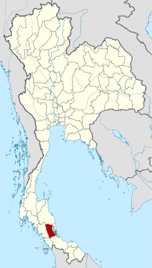
 Map of Thailand highlighting Phatthalung Province | ||
| Country |
| |
| Capital | Phatthalung | |
| Government | ||
| • Governor | Winai Kharuwannaphat (since October 2009) | |
| Area | ||
| • Total | 3,424.5 km2 (1,322.2 sq mi) | |
| Area rank | Ranked 58th | |
| Population (2014) | ||
| • Total | 520,419 | |
| • Rank | Ranked 47th | |
| • Density | 150/km2 (390/sq mi) | |
| • Density rank | Ranked 27th | |
| Time zone | ICT (UTC+7) | |
| ISO 3166 code | TH-93 | |
Phatthalung (Thai: พัทลุง, pronounced [pʰát.tʰā.lūŋ]) is one of the southern provinces (changwat) of Thailand.[1] Neighboring provinces are (from north clockwise) Nakhon Si Thammarat, Songkhla, Satun and Trang.
Geography
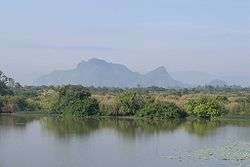
The province is on the Malay Peninsula. To the east it borders the large shallow Songkhla lake, while the west is covered by mountains of the Nakhon Si Thammarat chain. Khao Pu–Khao Ya National Park is at the border to Trang.[2]
History
Phatthalung was formerly known as Mardelong (Jawi: مردلوڠ) in Malay, especially during the time when the region came under Malay-Muslim influence.[3]
During the reign of King Ramathibodi I of the Ayutthaya kingdom in the 14th century, Phatthalung became one of twelve royal cities. At the end of the 18th century King Rama I submitted the city to the Ministry of Defense, which was responsible for all the southern provinces. During the administrative reform by King Chulalongkorn, Phatthalung became part of the Monthon Nakhon Si Thammarat.
Demographics
The majority of the province's populace are Thai Buddhists, although 11.1% of the population adhere to the Islamic faith. Many Muslims in Phatthalung have some ethnic Malay ancestry, who have gradually intermarried with the Thais and adopted Thai cultural norms.[4]
Symbols
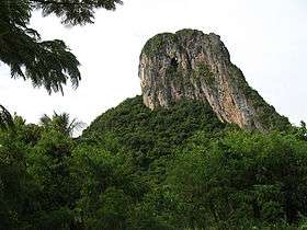
The provincial seal shows the 177 meter high Phu Khao Ok Thalu mountain, the symbol of the province.
The provincial tree as well as the provincial flower is the Sweet Shorea (Shorea roxburghii).
Administrative divisions

Phatthalung is subdivided into 11 districts (amphoe). The districts are further subdivided into 65 subdistricts (tambon) and 626 villages (muban).
Tourism
Sights
Phra Phutthanirarokhantarai Chaiyawat Chaturathit or Phra Si Mum Mueang (พระพุทธนิรโรคันตรายชัยวัฒน์จตุรทิศหรือพระสี่มุมเมือง) This bronze Buddha image in the posture of meditation is enshrined in a pavilion with four porches on the foreground between the city hall and provincial court of Phatthalung.
Wat Khuha Sawan (วัดคูหาสวรรค์) This is one of the ancient monuments of Phatthalung. Inside the cave, a giant reclining Buddha image, pagoda, and other Buddha images are found together with some earthen votive tablets of the Srivijaya period.

Khao Ok Talu (เขาอกทะลุ) Phatthalung's "mountain", having a height of around 250 m. There is a flight of stairs leading the way up to the mountaintop overlooking the city of Phatthalung.
Wat Wang (วัดวัง) The ubosot (ordination hall) is in the architectural style of the Rattanakosin era, with the "Chofa", gable finial, "Bai Raka" crockets, and a front portico. One hundred and eight stucco Buddha images are enshrined in the gallery around the ordination hall.
Rulers' New and Old Palaces (วังเจ้าเมืองพัทลุง วังเก่า – วังใหม่) Once they served as a residence cum office of the governors of Phatthalung. Today, some parts of them remain. The palaces were registered as an ancient monument in 1983.
Phraya Thukkharat (Chuai) Monument (อนุสาวรีย์พระยาทุกขราษฎร์ (ช่วย)) Phraya Thukkharat was a former monk named Phra Maha Chuai. During the Nine Armies War in the reign of King Rama I, Phra Maha Chuai assisted Phraya Phatthalung who headed a force of villagers to fight against and defeat the Burmese army. Later, he left the monkhood and was royally appointed as Phraya Thukkharat in charge of official duties as an assistant to the city ruler.[5]
Hat Saen Suk Lampam (หาดแสนสุขลำปำ) This sandy beach along the coastal line of Songkhla Lake is fringed by shady pine trees. The pavilion jutting into the sea called "Sala Lampam Thi Rak" serves as a viewpoint to admire the lake's surroundings.
Coconut Shell Handicraft Centre of Mueang Phatthalung (ศูนย์รวมหัตถกรรมกะลามะพร้าวเมืองพัทลุง) This is a village of handicrafts made from coconut shell.
Thale Noi Non-hunting Area (เขตห้ามล่าสัตว์ป่าทะเลน้อย) The first non-hunting area ever founded in Thailand. Interesting things at the Thale Noi Waterfowl Park are the Thale Noi Palace, sea of blooming lotus in the morning, flocks of waterfowls, the nesting and egg-laying grounds of waterfowls at Ao Mo and those at Khuan Thale Mong, Khuan Khi Sian Ranger Station, and the Sala Nang Riam viewpoint. Thale Noi lake is a unique bird breeding place, with over 180 species of birds listed.
Wat Khian Kaeo (วัดเขียนบางแก้ว) It was recognized as a model temple for development in 1990. In addition, the temple houses a museum where Buddha images and crockery have been collected.
Laem Chong Thanon (แหลมจองถนน) A fishing village in Tambon Chong Thanon.
Namtok Phraiwan (น้ำตกไพรวัลย์) This large-scale waterfall is tranquil and full of shady trees.
Namtok Lan Mom Chui (น้ำตกหม่อมจุ้ย) A waterfall amidst a shady forest in the area of the Ban Tamot Wildlife Protection Unit.
Khao Pu – Khao Ya National Park (อุทยานแห่งชาติเขาปู่ – เขาย่า) The most geographical features are forests in the Banthat Range which has a complex of mountains with Khao Hin Thaen as the highest mountaintop. Most of the flora is moist evergreen forest. Wild animals consist of 60 species of mammals. In addition, other places of interest are as follows:-
- Tham Matcha Pla Won (ถ้ำมัจฉาปลาวน) A cave, about 2 km from park headquarters. Inside, there are 3 spacious chambers, stalactites, stalagmites, a limestone curtain, and many bats. The Asian giant toad and millipede are also found here.
- Pha Phueng (ผาผึ้ง) A limestone cliff, around 300 m from the park headquarters. Giant bees always come to make hundreds of hives here every year from February to April.
Bang Kaeo Shadow Puppet Figure and Handicraft Centre (ศูนย์ศิลปหัตกรรมรูปหนังบางแก้ว) The Bang Kaeo Handicraft village consists of 25 members who carve hides into puppet figures for Nang Talung and Nang Yai shadow plays, as well as new figures in patterns required by customers.
Tham Sumano (ถ้ำสุมะโน) Inside, there are some stalactites and stalagmites, as well as spacious chambers. The cave is cool and shady with spectacular nature. It includes a system of 18 small caves. The cave is also used for insight development and Dharma practices.
Local products
Famous souvenirs include "kalamae" or coconut toffee, "kluai chap" or crispy buttered banana, and "luk yi" (velvet tamarind) candy, and crispy baked prawns.
Culture
Arts
Manora or Nora (มโนราห์หรือโนรา) A local performing art in the south. It was an influence from the south of India, together with Lakhon Chatri (theatrical show by males). However, some dancing patterns were changed to match folk cultures in each province. There are 12 major dancing patterns. The audience will see dancing patterns and listen to lyrics sung by dancers, be they impromptu or composed verses.
Talung (ตะลุง) A popular folk performance in the south. Talung puppet figures are made of dried sheets of cattle hide cut and carved beautifully into characters for a shadow play. The characters are usually painted wholly in black and each of them is put firmly between a split bamboo slat called "mai tap". A character’s mouth and hands will be moved to accord with the narration. A Talung ensemble comprises puppet masters who are also vocalists, and a band, totalling not over eight persons. The musical instruments include pipe, drum, phon (a drum), and gong.
Festivals
Thale Noi Bird-watching Festival Initiated in 1998 as an activity for the "Amazing Thailand Year", designed around the most important attraction of Phatthalung.
Khaeng Phon Lak Phra or Chak Phra Tradition (งานประเพณีแข่งโพนลากพระหรือชักพระ) Held on the fourteenth day of the waxing moon, the full moon day and the first day of the waning moon in the eleventh lunar month, which coincides with the end of Buddhist Lent. It is a tradition to move around Buddha images both by land and by river. In Phatthalung, it is observed by land. Beating phons (drums) control the movement of a Buddha image procession. Each procession representing a temple has its own drum beaters. When two processions meet, they exchange a challenging medly of drum beating. A phon beating competition is, therefore, held every year at the Phatthalung Stadium and Hat Saen Suk Lampam (Lampam Beach), Amphoe Mueang Phatthalung. Activities in the event include a phon drumming contest by representatives from temples in Phatthalung and neighbouring provinces, a phon procession contest, a phon beating style contest, dancing performances, Sat Tom (throwing a traditional dessert made of sticky rice wrapped with a young leaf of Kapho or mangrove fan palm), a Buddha image procession contest, religious rites, water sports on Lampam Lake, local arts and exhibition of Phatthalung and nearby provinces, such as Krachut or bulrush mat weaving and coconut shell products.
References
- ↑ "Phatthalung". Tourism Authority of Thailand (TAT). Retrieved 23 May 2015.
- ↑ "Khao Pu-Khao Ya National Park". Department of National Parks (DNP) Thailand. Retrieved 23 May 2015.
- ↑ C. Skinner (1985). The Battle for Junk Ceylon: The Syair Sultan Maulana. Foris Publications. p. 272. ISBN 90-6765-066-8.
- ↑ William Chambers (publisher), Robert Chambers (1898). Chambers's Journal. W. & R. Chambers. p. 539.
- ↑ "Phraya Thukkharat (Chuai) Monument". Tourism Authority of Thailand (TAT). Retrieved 23 May 2015.
External links
| Wikimedia Commons has media related to Phatthalung Province. |
 Phatthalung travel guide from Wikivoyage
- Website of the province (Thai only)
- Phattalung provincial map, coat of arms and postal stamp Archived October 6, 2010 at the Wayback Machine
 |
Nakhon Si Thammarat Province |  | ||
| Trang Province | |
Songkhla Province | ||
| ||||
| | ||||
| Satun Province |
| ||||||||||||||||||||||||||||||
Coordinates: 7°36′56″N 100°04′22″E / 7.61556°N 100.07278°E
