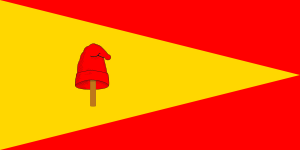
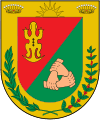
Pereira, Colombia
| Pereira | |||
|---|---|---|---|
| City | |||
| |||
| Nickname(s): La Querendona, Trasnochadora y Morena | |||
| Motto: Pereira con Vida | |||
 Location of the city and municipality of Pereira in Risaralda Department. | |||
 Pereira Location in Colombia | |||
| Coordinates: 4°48′51.4″N 75°41′40.41″W / 4.814278°N 75.6945583°WCoordinates: 4°48′51.4″N 75°41′40.41″W / 4.814278°N 75.6945583°W | |||
| Country | Colombia | ||
| Department | Risaralda | ||
| Region | Andean | ||
| Foundation | August 30, 1863 | ||
| Government | |||
| • Mayor | Enrique Vásquez Zuleta | ||
| Area | |||
| • City | 702 km2 (271 sq mi) | ||
| • Metro | 628 km2 (242 sq mi) | ||
| Elevation | 1,411 m (4,629 ft) | ||
| Population (2005 est.) | |||
| • City | 576,329 | ||
| • Density | 820/km2 (2,100/sq mi) | ||
| Demonym(s) | Pereira | ||
| Time zone | Eastern Time Zone (UTC-05) | ||
| Area code(s) | 57 + 6 | ||
| Website | Official website (Spanish) | ||
Pereira is the capital city of the Colombian Department (governmental region) of Risaralda. It is located in the west of Colombia in the foothills of the Andes in a coffee producing area.[1]
Location

Pereira is located in the Central Cordillera (mountain range) of Colombia in the valley of the river Otún and part of the Cauca river valley. To the north is La Virginia and Marseille Dosquebradas. To the northeast is Santa Rosa de Cabal and to the east is Tolima. To the south is Quindío and Valle del Cauca and to the west is Balboa and Valle del Cauca.
Geography
The city follows the relief of the land with some steep or high areas. Its elevation is about 1,500 metres (4,900 ft). It is located in a zone of high seismic vulnerability.[2]
Waterways
The river system of the municipality includes the rivers Cauca, Barbas, Old, the Otún River, the Consota and many tributaries.
History
Origin
The indigenous people of Pereira were the Quimbaya, a community of gold artisans.[3]
Colonial settlement
In about 1540 CE, the Spanish arrived in the area. The first settlement, Cartago Viejo was founded by the conquistadors, Jorge Robledo and Diego de Mendoza. In about 1691, the settlement was moved to the current location of Pereira.[4]
Independence
In 1816, the brothers, José Francisco and Manuel Pereira, took shelter near the settlement after the defeat of Simón Bolivar and his army at the Battle of Cachiri. José Francisco died on 24 August 1863. On 30 August 1863, Remigio Antonio Cañarte, a priest, arrived from Cartago and founded Pereira at the site, granted by the Pereira family for the city, which is now the Plaza de Bolivar.
Expansion and decline
In the 1920s particularly, settlers from Antioquia moved to Pereira for its economically strategic location, fertile soil, and good weather. The settlers grew large quantities of high-quality coffee in the mineral-rich, volcanic, Andean soil.[5] Other produce included sugarcane and cattle.[6] Settlers also came from cities such as Valle del Cauca and Bogotá. In the economic recession of 1999, and the low-growth years of 2000 and 2001, some residents of Pereira emigrated to the United States and Spain.
Governance

The Pereira municipal area covers 702 square kilometres (702,000,000 m2). Pereira is divided into 19 municipalities: Ferrocarril, Olímpica, San Joaquín, Cuba, Del Café, El oso, Perla del Otún, Consota, El Rocío, El poblado, El jardín, San Nicolás, Centro, Río Otún, Boston, Universidad, Villavicencio, Oriente y Villasantana. Pereira is a service centre for Altagracia, Arabia, Caimalito, Cerritos, La Florida, Puerto Caldas, Combia Alta, Combia Baja, La Bella, Estrella- La Palmilla, Morelia, Tribunas. Pereira, La Virginia, and Dosquebradas form the Area Metropolitana de Centro Occidente (AMCO).
Demographics
In 2005, Pereira had about 576,329 residents and was the sixth largest city of Colombia. Pereira has a twin city, Dosquebradas, (about five minutes drive from the Plaza de Bolivar), which has about 200,000 residents. The Pereira conurbation with a total population of about 986,000 includes Cartago, La Virginia, and Santa Rosa de Cabal. Pereira, Dosquebradas and La Virginia comprise the Pereira metropolitan area. As a result of urbanisation, Pereira is one of Colombia's cities with the most equitable distribution of wealth.[7]
Economy
68.1 percent of Pereira's economy lies in the tertiary sector, 26.2 percent in governance and 5.7 percent in primary production. The economy is supported by good prices for oil, coal, nickel and coffee; microcredit ventures; provision of security in the city and region; and taxes on residents living abroad.
Agriculture
In the region of Pereira, agricultural employment is 70 percent in permanent cropping, 8 percent in annual crops and 22 percent engaging transient workers. Agricultural products include a variety of crops such as sugarcane, cacao and rubber, cereals, coffee and livestock. Pereira is part of the Colombian coffee growing axis.[6]
Manufacturing
Pereira's main manufacturing product is apparel. Other products include aluminium goods, motorcycles and telecommunications technology. Pereira also hosts multinational corporations such as Avesco, Nestle and Coats. In the future, Ethanol may be produced in Pereira, as sugarcane (an essential raw material for ethanol production) is farmed in the nearby Cauca valley.[8]
Logistics
Pereira is a centre for transport logistics. Logistics companies include Servientrega International Logistics, FedEx, DHL, Central and TCC. There are logistics centres in Dosquebradas and Alpina.
Trade and commerce
Trade and commerce is the second biggest employment sector in Pereira and in 2010, Pereira is the city with the highest rate of unemployment in Colombia. Commercial enterprises include malls, home centres, hypermarkets and supermarkets. There are also fast food outlets, hotels and a convention centre.
Services
Pereira is a service centre for surrounding rural areas.
Tourism
Pereira has several landmarks which attract tourists. Lake Otún and Santa Isabel, provide a destination for sports adventure tourism. Pereira also has a "night life" with bars and nightclubs.
Transportation
Air
Pereira's airport is the Matecaña International Airport. It was built between 1944 and 1946 and opened in August 1947. It operates both nationally and internationally. It is currently undergoing a large expansion which will include a new control tower, a longer runway, new access roads and new destinations such as New York, which will make Matecaña International Airport one of the most important of the country,
Road
Pereira is a transport hub for Caldas and Quindio. Interdepartmental roads make up the Autopista del Café (Coffee Freeway).[9] Other routes include: 30 August Avenue, Circunvalar Avenue, Americas Avenue, Railway Avenue, Belalcazár Avenue, The River Avenue and streets Sixth, Seventh and Eighth and other highways.
Megabus
Megabús is the mass transport system of Pereira which was founded in 2006. It compromises 3 trunk routes that link Dosquebradas and Cuba, and feeder routes which connect the rest of the metropolitan area including La Virginia, Puerto Caldas, Cerritos, Morelia, and many other neighbourhoods, which connect with the trunk routes at Interchanger stations.
Cesar Gaviria Trujillo Viaduct
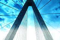
The architectural award winning César Gaviria Trujillo Viaduct, a cable-stayed bridge, was opened on 15 November 1997. It is named after César Gaviria, the 40th president of Colombia, who was born in the city of Pereira. The viaduct links Pereira with Dosquebradas and the cities of Armenia, Pereira and Manizales. The length of its centre span is 211 metres (692 ft), one of the longest in South America.[10]
Climate
Pereira is located in a warm moorland area. The average temperature is 22 °C (72 °F). The annual average rainfall is 2,750 millimetres (108 in). There is a large degree of biodiversity in the region.
| Climate data for Pereira, Colombia | |||||||||||||
|---|---|---|---|---|---|---|---|---|---|---|---|---|---|
| Month | Jan | Feb | Mar | Apr | May | Jun | Jul | Aug | Sep | Oct | Nov | Dec | Year |
| Record high °C (°F) | 32.0 (89.6) |
32.8 (91) |
34.6 (94.3) |
32.0 (89.6) |
30.0 (86) |
30.0 (86) |
32.0 (89.6) |
31.6 (88.9) |
31.8 (89.2) |
30.2 (86.4) |
32.0 (89.6) |
30.4 (86.7) |
34.6 (94.3) |
| Average high °C (°F) | 27.0 (80.6) |
27.1 (80.8) |
27.0 (80.6) |
26.3 (79.3) |
25.9 (78.6) |
26.1 (79) |
26.7 (80.1) |
26.8 (80.2) |
26.4 (79.5) |
25.7 (78.3) |
25.8 (78.4) |
26.3 (79.3) |
26.43 (79.56) |
| Daily mean °C (°F) | 21.6 (70.9) |
21.8 (71.2) |
21.7 (71.1) |
21.4 (70.5) |
21.1 (70) |
21.3 (70.3) |
21.5 (70.7) |
21.6 (70.9) |
21.2 (70.2) |
20.6 (69.1) |
20.7 (69.3) |
21.1 (70) |
21.3 (70.35) |
| Average low °C (°F) | 16.7 (62.1) |
16.9 (62.4) |
17.0 (62.6) |
17.0 (62.6) |
16.9 (62.4) |
16.8 (62.2) |
16.5 (61.7) |
16.5 (61.7) |
16.5 (61.7) |
16.5 (61.7) |
16.7 (62.1) |
16.8 (62.2) |
16.73 (62.12) |
| Record low °C (°F) | 12.2 (54) |
13.0 (55.4) |
13.6 (56.5) |
12.4 (54.3) |
13.4 (56.1) |
11.0 (51.8) |
12.4 (54.3) |
10.0 (50) |
13.0 (55.4) |
12.3 (54.1) |
12.0 (53.6) |
12.4 (54.3) |
10 (50) |
| Average precipitation mm (inches) | 135.3 (5.327) |
121.0 (4.764) |
191.1 (7.524) |
221.3 (8.713) |
255.2 (10.047) |
178.7 (7.035) |
123.4 (4.858) |
134.4 (5.291) |
185.3 (7.295) |
267.6 (10.535) |
271.3 (10.681) |
173.6 (6.835) |
2,258.2 (88.905) |
| Average precipitation days | 15 | 14 | 18 | 21 | 23 | 21 | 18 | 17 | 20 | 24 | 22 | 18 | 231 |
| Average relative humidity (%) | 74 | 74 | 76 | 78 | 79 | 78 | 75 | 74 | 76 | 79 | 79 | 77 | 76.6 |
| Mean monthly sunshine hours | 189.8 | 164.6 | 163.3 | 134.1 | 134.8 | 149.6 | 185.2 | 180.0 | 150.6 | 141.9 | 151.1 | 170.8 | 1,915.8 |
| Source: Instituto de Hidrologia Meteorologia y Estudios Ambientales.[11] | |||||||||||||
Places of interest
.jpg)
- Matecaña City Zoo, natural history museum and visitors' train.
- Technological University of Pereira, (planetarium and botanical garden of Pereira Technological University and Guaducto, a bamboo bridge).[1]
- Cathedral of Our Lady of Poverty.
- Lucy Tejada, cultural centre.
- Museum of Art, Pereira.
- Jaime Mejia archaeological museum.
- Sanctuary of Our Lady of Fatima.
- Confamiliar recreation centre: Noah's farm eco-park, water park.
- Olympic venues: village, pools, tennis courts, basketball courts and velodrome.
- Los Nevados National Natural Park.
- Botanical Garden of Marseille.
- Plaza de Bolívar and the naked Bolívar statue.[12]
- Victoria's City square mall.
Monuments
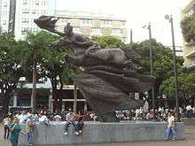
- Monument to the founders, Rodrigo Arenas Betancur
- Prometheus bound, Universidad Tecnológica de Pereira, Rodrigo Arenas Betancur.
- Christ without the cross, Our Lady of Fatima church, Rodrigo Arenas Betancur.
- The Rebecca, Circunvalar park, Cardigan Ave., Larry Mendez.
- Train: monument of transport", transportation terminal.
- Alexandra Ariza, Jorge Eliecer Gaitan park, opposite the St. George hospital, Jorge Eliecer Gaitan
- The Obelisk, Hernando Hoyos.
- Diana of the Gavi and the young of Jar.
- General Rafael Uribe Uribe, Franco A. Cano.
- The Traveler, Antonio Segui.
Education
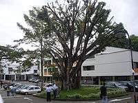
Places of learning in Pereira include:
- Technological University of Pereira
- Universidad Católica de Pereira
- Free University of Colombia
- Andina University
- Cooperative University of Colombia
- National University of Colombia distance learning campus
- Saint Thomas Aquinas University campus
- CEIPA University,
- Antonio Nariño University
- Autonomous University of the Americas.
Pereira also has a number of training institutions associated with the National Learning Service (SENA).
Fiesta de la Cosecha
The Fiesta de la Cosecha (Harvest Fest) is celebrated on the anniversary of the founding of the city. it has led to phrases such as asi no vamos a llegar a ningún Pereira ("This way, we'll never get to Pereira", meaning "this is useless") and hicieron su Agosto ("they made their August", meaning that someone made a really good deal, referring to the belief that everyone would sell all their merchandise at the festival of Pereira).[13]
Sports
Pereira's main football team is the Deportivo Pereira, which plays in the Categoría Primera B. The city hosts the Hernán Ramírez Villegas stadium, a velodrome, a skating area, an Olympic swimming pool and a motocross track. Pereira is also home to the "coffee marathon". Pereira is the birthplace of the Colombian tennis player, Santiago Giraldo.
Religion
The predominant religion is Catholicism. There are also Protestant churches.
Twin towns – Sister cities
Pereira is twinned with:
See also
- 1999 Armenia earthquake
- Matecaña International Airport
- César Gaviria Trujillo Viaduct
- Matecaña City Zoo
- Technological University of Pereira
- Deportivo Pereira
References
- 1 2 "Colombia green guide Michelin 2012-2013." Michelin. 2012. Accessed at Google Books 29 December 2013.
- ↑ Lallinde C. P. et al "Geological criteria for evaluating seismicity revisited: forty years of paleoseismic investigations and the natural record of past earthquakes." Geological Society of America, 2011 p79. ISBN 0813724791, 9780813724799. Accessed at Google Books 28 December 2013.
- ↑ Caputo L. "Colombia adventure guide." VIVA 14 July 2011. ISBN 1937157059, 9781937157050. Accessed at Google Books 28 December 2013.
- ↑ "Antiqueno colonization in Western Colombia." University of California Press. p77 Accessed at Google Books 28 December 2013.
- ↑ Sharpless R. E. "Gaitán of Colombia: a political biography." University of Pittsburgh 1978 p16. ISBN 0822976196, 9780822976196. Accessed at Google Books 29 December 2013.
- 1 2 Palacios M. "Coffee in Colombia, 1850-1970: an economic, social and political history." Cambridge University Press, 25 July 2002. p162. ISBN 0521528593, 9780521528597. Accessed at Google Books 29 December 2013.
- ↑ Hudson R. A. "Colombia, a country study." Government Printing Office, Library of Congress, USA. p95 ISBN 016088277X, 9780160882777.
- ↑ Toasa J. "Colombia: a new ethanol producer on the rise?" Diane publishing and Department of Agriculture, Economic Research Service, USA 2009 p4. ISBN 1437923674, 9781437923674. Accessed at Google Books 29 December 2013.
- ↑ "En servicio calzada de la Autopista del Café." Eldiario website. Accessed 1 February 2013.
- ↑ "Cesar Gaviria Trujillo Viaduct." Structurae, International database and gallery of structures. Website in English. Accessed 30 December 2013.
- ↑ "Cartas climatologicas, medias mensuales, aeropuerto Matecana." Instituto de Hidrologia Meteorologia y Estudios Ambientales. Spanish. Accessed 1 February 2013.
- ↑ Duncan R. J. "The Ceramics of Ráquira, Colombia: Gender, Work, and Economic Change." University Press of Florida, 1998. p93. Accessed at Google Books 29 December 2013.
- ↑ "Harvest Festivals." Colombia Festiva website, in English, 2011. Accessed 30 December 2013.
External links
| Wikivoyage has a travel guide for Pereira. |
- Official website. (Spanish)
- Megabús' official website. (Spanish)
- Pereira. (Spanish)
- Universidad Tecnologica.
- Portal of Pereira city. (Spanish)
- Constructora líder en Pereira y Risaralda. (Spanish)
| ||||||||
