Beitou
| Beitou 北投區 | |
|---|---|
| District | |
| Beitou District | |
|
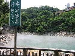
Hot Spring Valley in Beitou | |
 | |
| Country | Taiwan |
| Region | Northern Taipei |
| Divisions |
List
|
| Area | |
| • Total | 56.8216 km2 (21.9389 sq mi) |
| Area rank | Ranked 2nd of 12 |
| Population | |
| • Total | 257,922 |
| • Rank | Ranked 5th of 12 |
| • Density | 4,500/km2 (12,000/sq mi) |
| Postal code | 112 |
| Website | www.btdo.taipei.gov.tw (Chinese) |
| Beitou | |||||||||||||
| Traditional Chinese | 北投區 | ||||||||||||
|---|---|---|---|---|---|---|---|---|---|---|---|---|---|
| |||||||||||||


Beitou District is the northernmost of the twelve districts of Taipei City, Taiwan. The historical spelling of the district is Peitou. The name originates from the Ketagalan word Kipatauw, meaning witch. Beitou is the most mountainous and highest of Taipei's districts, encompassing a meadow with rivers running through the valley which have abundant steam rising from them; the result of geothermal warming. The valley is often surrounded by mist shrouding the trees and grass. Beitou is famous for its hot springs.[1] In March 2012, it was named one of the Top 10 Small Tourist Towns by the Tourism Bureau of Taiwan.[2]
History
In the early Japanese era, Hokuto (Pak-tau) was a village at the entrance of the well-known North Formosa sulfur district.[3] Three Japanese extracting plants in this district produced about 200 short tons (180,000 kg) of sulfur monthly. The Japanese had already recognized the value of the village as a sanitary resort and constructed a Japanese inn with hot mineral baths provided by the sulfur springs. The hot springs have been developed to include aroma therapy, massage, acupuncture, hydrotherapy, and excellent cuisine which complement the entire spa experience. The mineral waters stream from the numerous geothermal vents that occur naturally in the region and are famous for their health benefits.
Between 1920 and 1941, Hokutō Village (北投庄) was governed under Shichisei District (七星郡), Taihoku Prefecture. It was upgraded to a Hokutō Town (北投街) in 1941. After the handover of Taiwan from Japan to the Republic of China, it was renamed as Peitou urban township (北投鎮), belonging to Taipei County. Beginning in 1949, Peitou and Shilin were administered by the newly formed Yangmingshan Administrative Bureau (陽明山管理局). Both of them were merged into Taipei City in 1968 as districts.[4]
Economy
Asus has its headquarters in Beitou.[5]
Institutions
Education
Universities and colleges:
- Fu Hsing Kang College
- National Defense University
- National Taipei University of Nursing and Health Science
- National Yang-Ming University
- Taipei Chengshih University of Science and Technology
- Taipei National University of the Arts
- Mackay Medicine, Nursing and Management College
Junior and Senior High Schools:
- Zhong Zheng Senior High School
- Taipei Municipal Fuxing Senior High School
- Taipei Xin-Min Junior High School
- Taipei Beitou Junior High School
- Taipei Mingde Junior High School
Tourism
Beitou is one of the largest concentrations of hot springs and spas in the world. Once a small park where locals used to relax in the hot springs, the Beitou Valley has evolved today to include over thirty resorts; A 20-minute train ride north of Taipei takes you to Beitou. The resorts and spas are regarded by many locals and international tourists as among the most relaxing and rejuvenating places in the country. The spas consist of different degree pools (from cool to very hot) and minerals. However, residents of this district note that sulfuric fumes from the hot springs do ruin their electric appliances in the long term.
Tourist attractions
- Beitou Hot Spring Museum
- Beitou Museum
- Grass Mountain Chateau
- Guandu Temple
- Hong-gah Museum
- Ketagalan Culture Center
- Kuandu Museum of Fine Arts
- Nung Chan
- Taipei Public Library Beitou Branch
- Tittot Glass Art Museum
- Yangmingshan National Park
- Zhongxing Guesthouse
- Guandu Natural Park: birding
- Hot Springs in Xin Beitou and Xingyi Road
- Beitou Cape: Lighthouse and seaside resort
- Puji Temple
Transportation
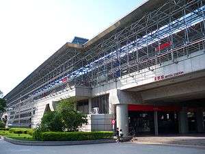
The district is served by Beitou Station, Xinbeitou Station, Zhongyi Station, Qiyan Station, Fuxinggang Station, Guandu Station, Qilian Station, Mingde Station and Shipai Station of the Taipei Metro.
See also
| Wikimedia Commons has media related to Beitou District, Taipei. |
References
- ↑ Jacobs, Andrew (2010-03-21). "Taiwan’s Steaming Pools of Paradise". The New York Times. Retrieved 2010-07-12.
- ↑ Wong, Maggie Hiufu (2012-03-30). "Taiwan names its 10 top small tourist towns". CNN Go. Retrieved 2012-03-31.
- ↑ Davidson, James W. (1903). The Island of Formosa, Past and Present : history, people, resources, and commercial prospects : tea, camphor, sugar, gold, coal, sulphur, economical plants, and other productions. London and New York: Macmillan. p. 621. OCLC 1887893. OL 6931635M.
- ↑ http://w2.dbas.taipei.gov.tw/NEWS_WEEKLY/summeng/3E.pdf
- ↑ "2007 Corporate Sustainability Report." Asus. 10 of 67. Retrieved on March 15, 2010. "ASUS has its headquarters located in No. 15, Li-Te Rd., Beitou, Taipei 11259, Taiwan."
External links
- - Photos of Beitou by Junewei(Wayne)
- Ku, Melody. Travel Taiwan. Central Coast Magazine, San Luis Obispo, CA. Dec. 2004.
- http://www.go2taiwan.net/monthly_selection.php?sqno=23
- http://sinotour.com/tourguide/taipei/beitou-hot-spring.html
| |||||||||||||||||||||||||||||
| ||||||||||||||||||||||||||||||||||||||||||||||
Coordinates: 25°07′00″N 121°30′00″E / 25.1167°N 121.5°E


.svg.png)