Paseo de Roxas
 | |
| Length | 1.8 km (1.1 mi) |
|---|---|
| Location | Makati, Metro Manila |
| From | Arnaiz Avenue in San Lorenzo Village |
| Major junctions |
Legazpi Street De La Rosa Street Ayala Avenue Makati Avenue |
| To | Gil Puyat Avenue in Bel-Air Village |
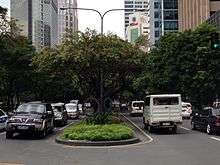
Paseo de Roxas is a prime commercial artery in the Makati Central Business District of Metro Manila, Philippines. It is a six-lane avenue that cuts through the middle of the business district connecting San Lorenzo Village in the west to Bel-Air Village in the east.
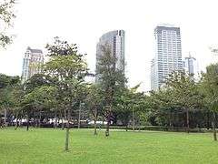
Starting at its western terminus at Arnaiz Avenue, the Paseo crosses into Legaspi Village passing by the Greenbelt mall complex, the Asian Institute of Management, as well as several low to mid rise office and residential towers. As it enters Salcedo Village east of Ayala Avenue, the buildings give way to high rises on the north side and the entire length of the Ayala Triangle Gardens on the south. Past the intersection with Makati Avenue, Paseo de Roxas skirts the northern side of Urdaneta Village leading to its eastern terminus at Gil Puyat Avenue.
The avenue was named after Ayala Corporation founder Domingo Roxas of the Zobel de Ayala family that owns the land. It was the site of the old Nielson Field airport where it served as a runway along with Ayala Avenue.[1] Paseo de Roxas also has short extensions into the gated San Lorenzo Village as Edades Street and into the gated Bel-Air Village as Hydra Street.
Notable landmarks

- Asian Institute of Management
- Ayala Tower One
- Ayala Triangle Gardens
- Bank of the Philippine Islands Building
- Chinabank Building
- Citibank Tower
- Corinthian Plaza
- Equitable Bank Tower
- Eton Tower (u/c)
- Greenbelt
- Insular Life Building
- Lepanto Building
- Manila Mandarin Oriental Hotel
- One Roxas Triangle
- Paseo Center
- Philamlife Tower
- Philippine Savings Bank Center
- The Enterprise Center Tower 1
- The Residences at Greenbelt – Manila Tower
- Zuellig Building
References
- ↑ History of FHL published by Filipinas Heritage Library; accessed 2013-09-27.
Coordinates: 14°33′13″N 121°1′10″E / 14.55361°N 121.01944°E