Paina
| Paina पैना | |
|---|---|
| Village ( Nyaya Panchayat ) | |
|
| |
 Paina Location in Uttar Pradesh, India | |
| Coordinates: 26°15′05″N 83°46′52″E / 26.251339°N 83.781200°ECoordinates: 26°15′05″N 83°46′52″E / 26.251339°N 83.781200°E | |
| Country |
|
| State | Uttar Pradesh |
| Division | Gorakhpur |
| District | Deoria |
| Tehsil | Barhaj |
| Block | Barhaj |
| Government | |
| • Bansgaon (Lok Sabha constituency) | Kamlesh Paswan (BJP) |
| • Barhaj (Seat of State Legislative Assembly) | Prem Prakash Singh (SP) |
| Population (2011) | |
| • Total | 10,499 |
| Languages | |
| • Official | Hindi |
| • Regional | Bhojpuri |
| Time zone | IST (UTC+5:30) |
| PIN | 274604 |
| Telephone code | +91-5561 |
| Vehicle registration | UP 52 |
| Avg. annual temperature | 26 °C (79 °F) |
| Avg. summer temperature | 40 °C (104 °F) |
| Avg. winter temperature | 18 °C (64 °F) |
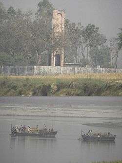
Paina (Hindi: पैना, Bhojpuri: पैना) is a village and Nyaya Panchayat situated along the bank of Sarayu(Ghaghra) river in the eastern part of the state of Uttar Pradesh in India. It comes under administration of Deoria District and Gorakhpur Division. It is located 33 km towards South from District headquarters Deoria and 340 km from State capital Lucknow.
Deubari (4 km), Telia Afgan (4 km), Nadua (4 km), Akuba (5 km), Gopalapar (5 km) are the nearby Villages to Paina. Paina is surrounded by Bhagalpur Tehsil towards South, Salempur Tehsil towards East, Bhaluani Tehsil towards North, Fatehpur Madaun Tehsil towards South. Lar, Rudrapur, Deoria, Adari are the nearby Cities to Paina.
Satraon and Sisai Gulabrai Railway Stations of North Eastern Railway Zone are the very nearby railway stations to Paina.[1]
It is located at the border of the Deoria District, Ballia District and Mau District.
History
Formation
According to the history, the village was developed by Kunwar Krit Shahi and the land was provided by landlord of Majhauli Raj.
Role in Freedom Movement of 1857
A Shaheed Smarak[2] was constructed by Government of Uttar Pradesh at south-western part of the village, in the memory of martyrs who took part in the India’s first war of freedom during 1857. It is situated at the bank of river Sarayu(Ghaghra) and the place locally known as "Satihara". It is a place to recall the memory of those brave unknown warriors who laid down their precious lives during the freedom struggle in 1857.[3] [4]
Education
- Shri Raghunath Singh Inter College [5]
- 1857 Shaheed Smarak High School
- Adharsh Uchchtar Madhymik Vidyalaya (East)
- Adharsh Uchchtar Madhymik Kanya Vidyalaya (Central)
- Adharsh Prathamik Vidyalaya (East,Central,West)
- Saraswati Shishu Mandir
See Also
References
- ↑ "N. E. Railway (NER)". Portal of Indian Railways.
- ↑ "Shahid Smarak, Paina". Wikimapia.
- ↑ "भारत की आजादी में पूर्वाचंल का योगदान". Google Blogger.
- ↑ "History, Paina". Bloger.
- ↑ "Shri Raghunath Singh Inter College". Madhyamic Shiksha Parishad website.
