Port Moresby
| Port Moresby Pot Mosbi | ||
|---|---|---|
|
Downtown Port Moresby | ||
| ||
 Port Moresby Location within Papua New Guinea | ||
| Coordinates: 9°30′49.1″S 147°13′7.7″E / 9.513639°S 147.218806°E | ||
| Country |
| |
| Division | National Capital District | |
| Established | 1873 | |
| Government | ||
| • Governor | Powes Parkop (2007-) | |
| Area | ||
| • Total | 240 km2 (90 sq mi) | |
| Elevation | 35 m (115 ft) | |
| Population (2011 census) | ||
| • Total | 364,125 | |
| • Density | 1,500/km2 (3,900/sq mi) | |
| Languages | ||
| • Main languages | Motu, Tok Pisin, English | |
| Time zone | AEST (UTC+10) | |
| Postal code | 111 | |
| Website |
www | |
Port Moresby (/ˌpɔərt ˈmɔərzbi/; Tok Pisin: Pot Mosbi), also referred to as Moresby and Pom Town, is the capital and largest city of Papua New Guinea (PNG). It is located on the shores of the Gulf of Papua, on the south-eastern coast of the Papuan Peninsula of the island of New Guinea. The city emerged as a trade centre in the second half of the 19th century. During World War II it was a prime objective for conquest by the Imperial Japanese forces during 1942–43 as a staging point and air base to cut off Australia from Southeast Asia and the Americas.
In 2000 it had a population of 254,158.[1] As of 2011 it had a population of 364,145, giving it an annual growth rate of 2.1% over a nine-year period . The place where the city was founded has been inhabited by the Motu-Koitabu people for centuries. The first European to see it was Captain John Moresby in 1873. It was named in honour of his father, Admiral Sir Fairfax Moresby.
According to a survey of world cities by the Intelligence Unit of The Economist, Port Moresby is one of the world's least livable cities (ranked 139 of 140 cities rated).[2]
Although Port Moresby is surrounded by Central Province, of which it is also the capital, it is not part of that province, but forms the National Capital District.
History

Before colonisation
The Motuan people of the area now known as Port Moresby traded their pots for sago, other food and canoe logs, sailing from Hanuabada and other villages built on stilts above the waters of the bay. Their language, Motu, was the basis of Hiri Motu, an official language of Papua New Guinea. It has been steadily in decline since the 1960s when Tok Pisin (till then confined to the northern side of the former border between Papua, British New Guinea until 1905, and New Guinea, that was German New Guinea until 1914) began to grow in popularity.
The Hiri expeditions were large scale. As many as 20 multi-hulled canoes or lakatoi, crewed by some 600 men, carried about 20,000 clay pots on each journey. To the Motuans, the Hiri was an economic enterprise and it confirmed their tribal identity through its long and dangerous voyages.

Colonisation
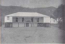
There was already an important trade centre on the site of Port Moresby when the English Captain John Moresby of HMS Basilisk first visited it. He sailed through the Coral Sea at the eastern end of New Guinea, saw three previously unknown islands, and landed there. At 10 a.m. on 20 February 1873, he claimed the land for Britain and named it after his father, Admiral Sir Fairfax Moresby. He called the inner reach "Fairfax Harbour" and the other Port Moresby.
In 1883 Queensland attempted to annex the south-eastern corner of the New Guinea Island (subsequently known as Papua), fearing that Germany would take control of the entire eastern half of the island. British authorities refused to approve the annexation following the German annexation of New Guinea in 1884, but four years later it established a protectorate over Papua as British New Guinea.
In 1905 the recently federated Australian government passed the Papua Act which came into effect in 1906. The act transferred Papua, with Port Moreseby as its capital, to direct Australian rule. From then until 1941 Port Moresby grew slowly. The main growth was on the peninsula, where port facilities and other services were gradually improved. The first butcher's shop and grocery opened in 1909,[4] electricity was introduced in 1925,[5] and piped water supply provided in 1941.[6]
World War II and after


During World War II, some Papuan men enlisted in the Papua Infantry Battalion and others as carriers over trails and rough terrains (porters) as supply support to Allied and Japanese armies during long jungle marches.[7] Historian William Manchester makes it plain in his biography of General Douglas MacArthur, American Caesar, that acting as porters was well down the natives' list of acceptable voluntary activities and that they would fade away without great inducements.[8] Many Papuan residents of Port Moresby either returned to their family villages or were evacuated to camps when the threat of Japanese invasion loomed. The city became, by September 1942, home to an important Allied complex of bases and thousands of troops were eventually stationed in the area or more often, staged through it, as it was the last Allied bastion on the island[9][10] and, conversely, a key staging and jumping off point as the Allies began conducting offensive warfare themselves, pushing back the Japanese advances.[11]
In 1945, the Territory of Papua and New Guinea was formed when Papua and the former German New Guinea, which had been administered by Australia since 1918, were amalgamated under a single Australian administration though several laws remained in two territories and remain so, which can be complicating with provinces sitting on two sides of the otherwise extinct boundary. Port Moresby became the capital of the new combined territory and a focal point for the expansion of public services.
-

The longstanding downtown United Church with next door office building in 2013 were replaced with one building, the church on the ground floor
-
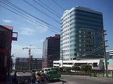
Looking past Pacific Place showing building beneath it which will block the view of the harbour from the street
-

Port Moresby's Roman Catholic cathedral remains downtown though parishioners largely come from elsewhere in the city
-
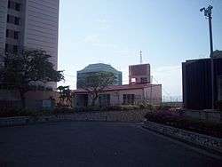
The current Anglican cathedral replaces the building dating back to the first part of the 20th century
-

Office and apartment tower on Ela Beach at the bottom of Musgrave Street
-

Port Moresby Post Office in 2013 with office buildings behind which once contained restaurants
Independence

In September 1975, Papua New Guinea became an independent country with Port Moresby as its capital city. Prince Charles, Prince of Wales, represented the Queen of Papua New Guinea at the celebrations.[12] New government, intellectual and cultural buildings were constructed in the suburb of Waigani to supplement and replace those of downtown Port Moresby. They included those for government departments, including a National Parliament Building, which was opened in 1984 by Prince Charles and blends traditional design with modern building technology.[12]
The PNG National Museum and National Library are in Waigani. A mansion was built in Port Moresby just west of the old legislative building but the last pre-independence chief minister and first prime minister of the sovereign state declared it not nearly grand enough; it was made the residence of Australian high commissioners and a mansion suitable to Somare's demands was built in Waigani.
-

National library and archives in Waigani in 2013
-

Pineapple Building being restored in 2013 after many years of abandonment
-

Old courthouse in downtown Port Moresby bearing the Royal Arms of the United Kingdom
-

PNG National Court building in Waigani, in 2013 with substantial repair and enlargement with additional wing
Several of the government buildings have been abandoned due to long-term neglect. Chief amongst these are Marea Haus (known to most locals as the "Pineapple Building") and the Central Government Offices. Nearby buildings, such as Morauta Haus and Vulupindi Haus, are starting to show significant signs of decay due to a lack of maintenance. However, widespread restoration rather than demolition of long-disused office buildings has been highly active since the first decade of the 21st century. The legislative building before independence and the first parliament building is long-gone but the old court house in town Port Moresby remains, bearing its pre-independence label with its previous title.
The population of the Port Moresby area expanded rapidly after independence. In 1980 the census registered 120,000; by 1990, this had increased to 195,000.
Climate
Port Moresby has a tropical wet and dry climate with relatively constant temperatures throughout the year. The wet season starts in December and ends in May; the dry season covers the remaining six months. Port Moresby's average yearly rainfall is just over 1,000 mm (39.4 in). Average daily high temperatures range from 28 to 32 °C (82 to 90 °F) depending on time of year, while the average low temperature shows very little seasonal variation, hovering around the 26 °C (79 °F) mark. It tends to be slightly cooler in the city during the dry season.
| Climate data for Port Moresby, Papua New Guinea | |||||||||||||
|---|---|---|---|---|---|---|---|---|---|---|---|---|---|
| Month | Jan | Feb | Mar | Apr | May | Jun | Jul | Aug | Sep | Oct | Nov | Dec | Year |
| Record high °C (°F) | 36.2 (97.2) |
36.1 (97) |
35.4 (95.7) |
34.2 (93.6) |
33.8 (92.8) |
33.9 (93) |
33.3 (91.9) |
33.8 (92.8) |
34.8 (94.6) |
35.5 (95.9) |
36.3 (97.3) |
36.3 (97.3) |
36.3 (97.3) |
| Average high °C (°F) | 32.1 (89.8) |
31.6 (88.9) |
31.4 (88.5) |
31.3 (88.3) |
31.0 (87.8) |
30.3 (86.5) |
29.9 (85.8) |
30.3 (86.5) |
31.0 (87.8) |
32.0 (89.6) |
32.5 (90.5) |
32.4 (90.3) |
31.3 (88.3) |
| Daily mean °C (°F) | 27.4 (81.3) |
27.3 (81.1) |
27.1 (80.8) |
27.0 (80.6) |
26.9 (80.4) |
26.1 (79) |
25.7 (78.3) |
26.1 (79) |
26.5 (79.7) |
27.5 (81.5) |
27.6 (81.7) |
27.8 (82) |
26.9 (80.4) |
| Average low °C (°F) | 23.7 (74.7) |
23.5 (74.3) |
23.4 (74.1) |
23.5 (74.3) |
23.5 (74.3) |
23.1 (73.6) |
22.4 (72.3) |
22.6 (72.7) |
23.2 (73.8) |
23.5 (74.3) |
23.6 (74.5) |
23.7 (74.7) |
23.3 (73.9) |
| Record low °C (°F) | 20.4 (68.7) |
18.8 (65.8) |
18.3 (64.9) |
16.8 (62.2) |
14.5 (58.1) |
14.5 (58.1) |
10.4 (50.7) |
14.8 (58.6) |
14.4 (57.9) |
16.3 (61.3) |
16.0 (60.8) |
19.6 (67.3) |
10.4 (50.7) |
| Average precipitation mm (inches) | 192.2 (7.567) |
140.6 (5.535) |
189.8 (7.472) |
105.2 (4.142) |
56.2 (2.213) |
21.6 (0.85) |
13.8 (0.543) |
12.0 (0.472) |
14.4 (0.567) |
15.2 (0.598) |
40.0 (1.575) |
97.8 (3.85) |
898.8 (35.386) |
| Average precipitation days (≥ 0.1 mm) | 18 | 16 | 18 | 11 | 9 | 6 | 4 | 4 | 5 | 5 | 6 | 12 | 114 |
| Average relative humidity (%) | 79 | 81 | 81 | 82 | 81 | 79 | 77 | 76 | 76 | 76 | 75 | 77 | 78 |
| Mean monthly sunshine hours | 182 | 158 | 184 | 200 | 211 | 200 | 203 | 222 | 213 | 231 | 243 | 216 | 2,463 |
| Source #1: World Meteorological Organization[13] | |||||||||||||
| Source #2: Deutscher Wetterdienst (extremes, mean temperature, humidity and sun)[14][15][lower-alpha 1] | |||||||||||||
District, LLGs and suburbs

-

Walter Bay from hills immediately east of downtown Port Moresby
-

Koki neighbourhood
-
Ela Beach
-

Streets and buildings in Boroko 2013
-

Port Moresby Harbour with floating and sunk ships described by Margaret Mead in 1929
Port Moresby is the single district of the National Capital District, which contains three Local Level Government (LLG) areas. For census purposes, the LLG areas are subdivided into wards and those into census units.[16]
| District | District Capital | LLG Name |
|---|---|---|
| National Capital District | Port Moresby | Moresby North-East |
| Moresby North-West | ||
| Moresby South |
Port Moresby refers to both the urbanised area of the National Capital District and more specifically to the main business area, known locally as "Town".
Since the 1990s the original town centre has ceased to have restaurants and night life, though it is very successful and prosperous looking as an office centre. The affluent housing region north of downtown along and up from the coast remains so, though there are now few modest residential houses, most of which are replaced with substantial mansions and apartment buildings.
The suburb of Boroko, once the commercial heart of Port Moresby, is very idle, with many former shopping buildings now empty; the west is full of high rises, shopping centres and affluent housing. Other neighbourhoods of Port Moresby include Koki, with its popular fresh produce market, Newtown, Konedobu, Kaevaga, Badili, Gabutu, Kila Kila, Matirogo, Three Mile, Kaugere, Sabama, Korobosea, Four Mile, Hohola, Hohola North, Boroko, Gordons, Gordons North, Erima, Saraga, Waigani, Morata and Gerehu. There are villages like Hanuabada, the largest in Papua New Guinea.
All parts of Port Moresby have serious security problems with violent attacks by criminals, with fences and walls considered necessary around houses and apartment buildings. Security guards are widely employed. The UN Global Compact Cities Programme, using a method called Circles of Sustainability has assessed the urban security of Port Moresby as 'critical'.[17]
Transport

Port Moresby is served within the city by buses and privately owned taxis. Flights are vital for transport about the country, highways not being widely available. Port Moresby is served by Jacksons International Airport, the biggest international airport and Papua New Guinea Defence Force Air Wing base in the country. Air Niugini and Airlines PNG conduct regular domestic and international services from the airport, while Virgin Australia flies to Brisbane. Jacksons has international flights to Brisbane, Cairns, Cebu, Sydney, Honiara, Nadi, Port Vila, Manila, Bali (Denpasar), Singapore, Hong Kong and Tokyo.
As the national highway system is not fully linked, there are many internal flights to other towns, e.g., Madang, which cannot be reached by ground transport, such as minibuses, known locally as PMVs (public motor vehicles).
Economy

In recent years Port Moresby has been economically booming. There has been substantial building of housing, office towers and commercial establishments over much of it, apart from the once significant but now vastly depressed Boroko. Airlines PNG has its head office on the grounds of Jacksons International Airport.[18]
Sports
The 1969 South Pacific Games held from 13–23 August 1969 at Port Moresby was the third edition of the South Pacific Games. A total of 1,150 athletes participated in the games.[19]
The 1991 South Pacific Games held from 7–21 September 1991 at Port Moresby and along Lae was the ninth edition of the South Pacific Games. This was the first time that events at one games had been held in two cities. The decision to do so was to allow both locations to benefit from the construction of new facilities.[20]
The 2015 Pacific Games was held in Port Moresby from 4 to 18 July 2015.[21] In September 2009, the Pacific Games Council, at its meeting coinciding with the 2009 Pacific Mini Games, elected Port Moresby as the host of the 2015 Games. The final vote was 25-22 in favor of Port Moresby over Tonga to host.[22]
Papua New Guinea Cricket Board is the official governing body of the sport of cricket in Papua New Guinea. Its current headquarters is in Port Moresby. Papua New Guinea Cricket Board is Papua New Guinea's representative at the International Cricket Council and is an associate member and has been a member of that body since 1973. It is also a member of the East Asia-Pacific Cricket Council.[23][24]
Sports venues
- Amini Park is a cricket ground in Port Moresby.[25][26] The ground is named for the Amini family, several of whom have played cricket for Papua New Guinea (both the men's and women's teams),[27] the ground has seen the men's team play Australia, the West Indies and Victoria. The women's team played Japan in a three match series at the ground in September 2006.[28]
- Lloyd Robson Oval is a sporting ground in Port Moresby and has hosted 3 games for the 1989–1992 Rugby League World Cup. It has been the home ground for the Papua New Guinea national rugby league team since 1975. It has a total capacity of approximately 17,000 and is the National Stadium of Papua New Guinea.
- PMRL Stadium is a football stadium in Port Moresby and it is used mainly for football and hosts the home matches of PRK Hekari United of the Papua New Guinea National Soccer League and OFC Champions League. The stadium has a seating capacity of 15,000 spectators.[29]
- Hubert Murray Stadium is a sports venue located in Port Moresby and was developed for the 1969 South Pacific Games on reclaimed land at Konedobu that had previously been shoreline mangroves.[19] The athletics events and the opening and closing ceremonies were held at the new stadium,[30] which was named after Sir Hubert Murray a former Lieutenant Governor.[31]
Twin towns
 Jinan, China (Province Shandong) since 28 September 1988
 Palm Desert, United States (California)
 Townsville, Australia (Queensland) since 1983
Associated town
References
- ↑ "citypopulation.de". citypopulation.de. Retrieved 2010-04-25.
- ↑ Dowling, Jason (15 August 2012). "Melbourne again most liveable city". The Age. Retrieved 15 August 2012.
- ↑ Its modesty -- still used today though substantially enlarged and altered -- demonstrates how plain in lifestyle the British and then Australians were compared with the ostentatious Germans of the period.
- ↑ "March of Civilisation". The Argus (The Argus Office, Melbourne Victoria). 7 September 1909. p. 5. Retrieved 29 November 2009.
- ↑ "Progress in Papua". The Argus (The Argus Office, Melbourne Victoria). 5 September 1925. p. 12. Retrieved 29 November 2009.
- ↑ "Department of the Interior: Tenders". The Argus (The Argus Office, Melbourne Victoria). 25 January 1941. p. 18. Retrieved 29 November 2009.
- ↑ "Australian War Memorial - AJRP Essays". Ajrp.awm.gov.au. Retrieved 2010-04-25.
- ↑ American Caesar, William Manchester, 1978, Little Brown Company, 793 pages, ISBN 0-316-54498-1, pp.306: "On and about Jul-Sep 1942 and MacArthur's troops stop the Japanese in the difficult jungles of New Guinea and General Kenney gifts Port Moresby to the SAC by moving the bomber line 1,800 miles [2,900 km] to five new air bases."
- ↑ "Amazon.com listing for the "Four Corners: A Journey into the Heart of Papua New Guinea"".
- ↑ Salak, Kira. "Nonfiction book about Papua New Guinea,"Four Corners"".
- ↑ American Caesar, William Manchester, 1978, Little Brown Company,793 pages, ISBN 0-316-54498-1, pp.290-307: "On and about Feb-Dec 1942 and MacArthur's reorganization of troops, lack of theater priority, his support for Guadalcanal and his daring offensive gamble in going to meet the Japanese in the difficult jungles of New Guinea as a way of conducting a forward defense of Australia, rather than risk a war of maneuver when he had insufficient forces to move around."
- 1 2 "Prince of Wales and Duchess of Cornwall to make Australian visit", The Telegraph, 19 September 2012, retrieved 21 September 2012
- ↑ "World Weather Information Service — Port Moresby". World Meteorological Organization. Retrieved 29 January 2016.
- ↑ "Klimatafel von Port Moresby (Flugh.) / Papua-Neuguinea" (PDF). Baseline climate means (1961-1990) from stations all over the world (in German). Deutscher Wetterdienst. Retrieved 29 January 2016.
- ↑ "Station 92035 Port Moresby W.O.". Global station data 1961–1990—Sunshine Duration. Deutscher Wetterdienst. Retrieved 29 January 2016.
- ↑ National Statistical Office of Papua New Guinea
- ↑ James, Paul; Nadarajah, Yaso; Haive, Karen; Stead, Victoria (2012). pdf download Sustainable Communities, Sustainable Development: Other Paths for Papua New Guinea Check
|url= - ↑ "APNG Contacts." Airlines PNG. Retrieved on 26 May 2010.
- 1 2 Hawthorne, Stuart (2011). Taim Bipo. Boolarong Press. pp. 88–89. ISBN 978-1-876344962. Retrieved 15 May 2015.
- ↑ Wightman, Brian (1992). "Ninth South Pacific Games in Port Moresby" (PDF 0.4 MB). Olympic Information Cente. pp. 50–53. Archived (PDF) from the original on 15 May 2015. Retrieved 15 May 2015.
- ↑ "Pacific Games dates set", Post-Courier, 18 April 2012
- ↑ PNG2015 - Papua New Guinea Wins, published by the Pacific Games Council, on 8 October 2009. Retrieved 8 October 2009.
- ↑ Cricinfo-Papua New Guinea
- ↑ cricketpng
- ↑ Amini Park at cricinfo
- ↑ Amini Park at CricketArchive
- ↑ Papua New Guinea players (A) at CricketArchive
- ↑ Other matches played on Amini Park, Port Moresby at CricketArchive
- ↑ Stadium information
- ↑ Taim Bipo
- ↑ Hubert Murray stadium work on schedule
Notes
- ↑ Station ID for Port Moresby is 92035 Use this station ID to locate the sunshine duration
Further reading
- James, Paul. et al., Sustainable Communities, Sustainable Development: Other Paths for Papua New Guinea (2012)
External links
| Wikimedia Commons has media related to Port Moresby. |
 Port Moresby travel guide from Wikivoyage
- Port Moresby official website
- Hugh Norwood Port Moresby Research Materials MSS 139. Special Collections & Archives, UC San Diego Library.
| ||||||||
| ||||||||||||||||||||||||||||||
| |||||||||||||||||||||||||
Coordinates: 9°28′42″S 147°08′53″E / 9.478472°S 147.148058°E
|

