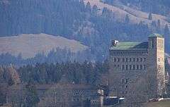
Ordensburg Sonthofen
| Generaloberst-Beck-Kaserne | |
|---|---|
 Exterior view (2007) | |
| Former names | NS-Ordensburg Sonthofen |
| General information | |
| Status | Complete |
| Type | Military Barracks |
| Architectural style | Nazi architecture |
| Location | Sonthofen, Oberallgäu |
| Completed | 1934 |
| Owner | Bundeswehr |
The Ordensburg Sonthofen is one of the NS-Ordensburgen built during the Third Reich in Sonthofen (Oberallgäu). Currently it belongs to the Bundeswehr and is named Generaloberst-Beck-Kaserne.
History

The complex was built in 1934 as NS-Ordensburg Sonthofen by the German Labour Front (Deutsche Arbeitsfront, DAF in short) for the NSDAP.
Three NS-Ordensburgen existed:
- Ordensburg Krössinsee, Pomerania
- Ordensburg Sonthofen, Allgäu
- Ordensburg Vogelsang, Eifel
A fourth one was planned at the historic Castle of the Teutonic Order in Malbork, in East Prussia (currently Poland).
It was designed by architect Hermann Giesler as a school for the education of elite Nazi military and party echelons. The internationally known actor Hardy Krüger attended this school. In the last year of the war it was used as sickbay.
Commander of the Ordensburg was, from 1936 to 1941, Robert Bauer, an Old Fighter of the Nazi party and member of the Reichstag since 1933.[1]
After the war French troops first took over the Castle. Later the US Army located the training center for the US-Constabulary force there.
In 1956 the Castle was acquired by the Bundeswehr and was named after the member of resistance and former chief of the general staff of the army Colonel General Ludwig Beck.
Current use
The Generaloberst-Beck-Kaserne hosted schools of the Bundeswehr (Military Police (Feldjäger) and Staff Service). In 2009 the Bundeswehr transferred these schools to the Emmich-Cambrai-Kaserne in Hannover. Two other bases were then closed and their personnel moved to Sonthofen.
Today the facility is protected as a historic site.
References
- ↑ Lutz Vogel (2012). "Bauer, Robert". Sächsische Biografie (in German). Institut für Sächsische Geschichte und Volkskunde e.V.
Literature
- Hartmut Happel: Die Allgäuer Ordensburg in Sonthofen. Eberl, Immenstadt 1996, ISBN 3-920269-01-2
- Gerhard Klein: Die NS-Ordensburg Sonthofen 1934 bis 1945. In: Paul Ciupke u. Franz-Josef Jelich (Hrsg.): Weltanschauliche Erziehung in Ordensburgen des Nationalsozialismus. Zur Geschichte und Zukunft der Ordensburg Vogelsang Geschichte und Erwachsenenbildung, Bd. 20. Essen 2006. S. 65 - 84
External links
Coordinates: 47°30′22″N 10°17′10″E / 47.506°N 10.286°E
|