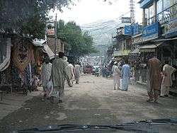
Oghi
| Oghi | |
|---|---|
| Town and union council | |
|
Oghi Market | |
 Oghi Location in Pakistan | |
| Coordinates: PK 34°30′N 73°0′E / 34.500°N 73.000°E | |
| Country |
|
| Province | Khyber Pakhtoonkhwa |
| District | Mansehra District |
| Time zone | PST (UTC+5) |
Oghi (Urdu: اوگی) is a city and union council (an administrative subdivision) of Mansehra District in the Khyber Pakhtoonkhwa of Pakistan.[1] It is located in Oghi Tehsil and lies to the north-west of the district capital Mansehra.[2]
History
During British Rule it was the headquarters of the Agror valley (part of Hazara District) and served as the headquarters of the Hazara border military police.[3] This Valley is green and surrounded by mountains. There is old fort or "Qila" built in 1865 and is currently the headquarters of the Frontier Constabulary (FC) Oghi District.
In British colonial times, Oghi town, in the Agror valley, was the seat of the local chief, the Khan of Agror, of the Swati tribe, descended from one Akhund Saadudin, a mullah who came from the Swat area and settled here. Following the disturbances by The Black Mountain (Tor Ghar) Tribes and campaign of 1888 this chiefdom was formally abolished by the government of British India; and subsequently, the chiefs were given a limited 'Jagir' grant in exile.[4] In the post-independence era, this family has been represented in Pakistani politics by the late Khan Facker uz Zaman Khan, and then his wife Senator Mrs. Fauzia Facker uz Zaman,[5] and their son, Mr. Wajih uz Zaman Khan, Advocate, who is an MP in the Provincial Assembly of Khyber-Pakhtoonkhwa.
In addition, many people from this area have migrated to big cities in Pakistan such as Lahore and Karachi as well as several countries abroad, and are running very successful businesses there, investing heavily in land back home.
People and language
About 58% of the population of the Oghi area is engaged in bucolic occupations, such as agriculture/cultivation, animal husbandry and livestock management and forestry; whereas most of the rest are either working as expatriates in other locations in Pakistan, or abroad; and some are also engaged in local small and medium-scale businesses. The main languages of the region are Pashto(70%) , followed by Hindko(22%), Gojri (5%) and others.[6] The main races and ethnic groups are: Swati, Hassanzai, Akazai, Mada Khel, Chagharzai, Tanoli, Awan, Gujar Sayyids and Bombay Rajas.
Settlements
In addition to the main Oghi town, the major settlements/villages in Oghi tehsil are Kathai,Trawara,Shahkot, Seri, Arbora, Bandi Sadiq, Dharra, Batang, Maloga, Ganian, Ghanian Bala, Shamdarra,Shaddore,Jishkot, Bagrian, Bawar Khan, Malookra, Malookra Chinar, Madina Colony, Bailiyaan, Maloga, Bazargaye, Kotla Agrore, Manchora, Rasheedah,kot,Arbora and Dehran followed by the South Eastern towns such as Shergarh, Gali Badrial and Qazi Abad, which were once part of the old Tanawal area, comprising the former princely states of Amb and Phulra.
References
- ↑ Tehsils & Unions in the District of Mansehra - Government of Pakistan
- ↑ Earthquake affected area overview - United Nations Joint Logistics Centre
- ↑ Oghi - Imperial Gazetteer of India, v. 19, p. 235.
- ↑ "Hazara District Gazetteer, 1907", Pub by the Government of the NWFP, 1908, pp. 203-205
- ↑ http://www.senate.gov.pk
- ↑ Pakistan National Census Report, 2000-2001
Coordinates: 34°30′N 73°00′E / 34.500°N 73.000°E
