Odienné
| Odienné | |
|---|---|
| Town, sub-prefecture, and commune | |
 | |
 Odienné Location in Ivory Coast | |
| Coordinates: CI 9°30′N 7°34′W / 9.500°N 7.567°WCoordinates: CI 9°30′N 7°34′W / 9.500°N 7.567°W | |
| Country |
|
| District | Denguélé |
| Region | Kabadougou |
| Department | Odienné Department |
| Population (2014)[1] | |
| • Total | 50,506 |
| Time zone | GMT (UTC+0) |
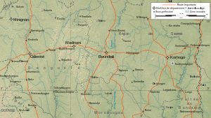
Odienné is a town in northwestern Ivory Coast. It is the seat of both Denguélé District and Kabadougou Region. It is also a commune and the seat of and a sub-prefecture of Odienné Department.
West of Odienné is the Den Kelen Massif. The town of Odienné was founded by Malinké people under Vakaba Tourié (who is buried in the town). Later, Samory Touré founded a support base in the town. Features of Odienné include a large mosque and nearby gold mines. The Den Kelen Massif is a solitary granite mountain, 600 metres above sea level, about 15 kilometres to the west of, and visible from, Odienné. "Den Kelen" means "one child" or "only child" in Jula, the local Manding variety.
The town is served by Odienné Airport. The Stade Municipal is a multi-purpose stadium in the town.
Climate
| Climate data for Odienné | |||||||||||||
|---|---|---|---|---|---|---|---|---|---|---|---|---|---|
| Month | Jan | Feb | Mar | Apr | May | Jun | Jul | Aug | Sep | Oct | Nov | Dec | Year |
| Average high °C (°F) | 33.4 (92.1) |
35.6 (96.1) |
35.3 (95.5) |
34.9 (94.8) |
33.2 (91.8) |
31.3 (88.3) |
29.8 (85.6) |
29.5 (85.1) |
30.2 (86.4) |
29.9 (85.8) |
32.6 (90.7) |
32.3 (90.1) |
32.3 (90.1) |
| Daily mean °C (°F) | 24.0 (75.2) |
27.1 (80.8) |
28.5 (83.3) |
28.4 (83.1) |
27.3 (81.1) |
25.8 (78.4) |
24.8 (76.6) |
24.5 (76.1) |
24.7 (76.5) |
25.3 (77.5) |
25.1 (77.2) |
23.3 (73.9) |
25.7 (78.3) |
| Average low °C (°F) | 14.7 (58.5) |
18.4 (65.1) |
21.3 (70.3) |
22.3 (72.1) |
21.9 (71.4) |
20.9 (69.6) |
20.5 (68.9) |
20.3 (68.5) |
20.4 (68.7) |
19.8 (67.6) |
18.2 (64.8) |
14.8 (58.6) |
19.5 (67.1) |
| Average precipitation mm (inches) | 43.0 (1.693) |
10.6 (0.417) |
33.4 (1.315) |
78.9 (3.106) |
118.8 (4.677) |
153.4 (6.039) |
283.5 (11.161) |
342.2 (13.472) |
251.2 (9.89) |
140.6 (5.535) |
31.5 (1.24) |
13.6 (0.535) |
1,500.7 (59.083) |
| Mean monthly sunshine hours | 242.0 | 220.2 | 217.3 | 214.7 | 248.8 | 221.8 | 183.5 | 174.5 | 185.4 | 235.8 | 252.0 | 242.6 | 2,638.6 |
| Source: NOAA[2] | |||||||||||||
References
- ↑ "Côte d'Ivoire". geohive.com. Retrieved 5 December 2015.
- ↑ "Odienné–Aero Climate Normals 1961–1990". National Oceanic and Atmospheric Administration. Retrieved December 21, 2015.
| ||||||||||||||||||||||||||||||||||
