Oberkrämer
| Oberkrämer | ||
|---|---|---|
|
Church in Vehlefanz | ||
| ||
 Oberkrämer | ||
Location of Oberkrämer within Oberhavel district  | ||
| Coordinates: 52°42′N 13°06′E / 52.700°N 13.100°ECoordinates: 52°42′N 13°06′E / 52.700°N 13.100°E | ||
| Country | Germany | |
| State | Brandenburg | |
| District | Oberhavel | |
| Government | ||
| • Mayor | Peter Leys | |
| Area | ||
| • Total | 10.754 km2 (4.152 sq mi) | |
| Population (2013-12-31)[1] | ||
| • Total | 10,522 | |
| • Density | 980/km2 (2,500/sq mi) | |
| Time zone | CET/CEST (UTC+1/+2) | |
| Postal codes | 16727 | |
| Dialling codes | 03304 | |
| Vehicle registration | OHV | |
| Website | www.oberkraemer.de | |

Oberkrämer is a municipality in the Oberhavel district, in Brandenburg, Germany. An experimental farm of wind turbines existed between 1941 to 1945 on the 50 m high Matthias mountain in the area.
Subdivisions
Oberkrämer consists of formerly separate districts, which as of 31 December 2001 merged with the new municipality of Oberkrämer. Current Population according Oberkrämer.de:[2]
| Year | Bötzow | Schwante | Vehlefanz | Neu-Vehlefanz | Marwitz | Bärenklau | Eichstädt |
|---|---|---|---|---|---|---|---|
| 2004 | 2.785 | 1.983 | 1.771 | 340 | 1.407 | 1.291 | 942 |
| 2005 | 2.904 | 1.997 | 1.777 | 348 | 1.400 | 1.294 | 939 |
| 2006 | 2.973 | 2.061 | 1.814 | 391 | 1.432 | 1.330 | 926 |
| 2007 | 2.947 | 2.061 | 1.821 | 379 | 1.435 | 1.313 | 929 |
| 2008 | 2.937 | 2.043 | 1.800 | 355 | 1.398 | 1.294 | 876 |
| 2009 | 2.967 | 2.039 | 1.759 | 365 | 1.417 | 1.270 | 848 |
| 2010 | 2.981 | 2.089 | 1.765 | 385 | 1.429 | 1.288 | 850 |
| 2011 | 2.955 | 2.019 | 1.746 | 353 | 1.413 | 1.262 | 843 |
Demography
-

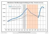
Development of Population since 1875 within the Current Boundaries (Blue Line: Population; Dotted Line: Comparison to Population Development of Brandenburg state; Grey Background: Time of Nazi rule; Red Background: Time of Communist rule)
-

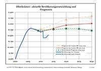
Recent Population Development (Blue Line) and Forecasts
|
|
|
|
Detailed data sources are to be found in the Wikimedia Commons.[4]
Photogallery
- Schwante
-

Manor
-

Park
-

Former water tower
References
- ↑ "Bevölkerung im Land Brandenburg nach amtsfreien Gemeinden, Ämtern und Gemeinden 31. Dezember 2013 (Fortgeschriebene amtliche Einwohnerzahlen auf Grundlage des Zensus 2011)". Amt für Statistik Berlin-Brandenburg (in German). 2014.
- ↑ http://www.oberkraemer.de → Gemeinde Oberkrämer → Zahlen, Daten, Fakten (in German)
- ↑ Boundaries as of 2013
- ↑ Population Projection Brandenburg at Wikimedia Commons
External links
![]() Media related to Oberkrämer at Wikimedia Commons
Media related to Oberkrämer at Wikimedia Commons
| ||||||||
|

