Noto, Ishikawa
| Noto 能登町 | |
|---|---|
| Town | |
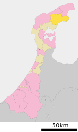
 Location of Noto in Ishikawa Prefecture | |
 Noto Location in Japan | |
| Coordinates: 37°18′N 137°9′E / 37.300°N 137.150°ECoordinates: 37°18′N 137°9′E / 37.300°N 137.150°E | |
| Country | Japan |
| Region |
Chūbu Hokuriku |
| Prefecture | Ishikawa Prefecture |
| District | Hōsu |
| Area | |
| • Total | 273.45 km2 (105.58 sq mi) |
| Population (October 2004) | |
| • Total | 21,863 |
| • Density | 80/km2 (200/sq mi) |
| Time zone | Japan Standard Time (UTC+9) |
| City Hall Address | 927-0492 |
| Website |
www |
Noto (能登町 Noto-chō) is a town located in Hōsu District (formerly Fugeshi District), Ishikawa Prefecture, Japan, famous for the traditional Abare Festival.
On March 1, 2005 the town of Noto and the village of Yanagida, both formerly from Fugeshi District, merged with the town of Uchiura, formerly from Suzu District, to form the new town of Noto. Also on this date, Fugeshi District merged with Suzu District to become the newly created Hōsu District.
According to October 2004 population statistics, the town has an estimated population of 21,863 and a density of 80 persons per km². The total area is 273.45 km².
Name
The old name (before merger) and the new name (after merger) have the same pronunciation ("No-to"), but the characters are different.
- Old: 能都 ("central Noto area")
- New: 能登 ("Noto area itself")
Roads
- Main Roads
- Route 249 (a road that loops the prefecture, following the coast)
- Suzu Road (an east west road cutting through the center of noto-town that connects suzu to the toll road and the airport)
- Prefectural Road 6 (a north south road that connects Ushitsu to Wajima with Yanagida in the middle.)
Products
- Kanburi (adult yellowtail fish captured in winter)
- Strawberries of Akasaki
- Blueberry Jam/Vine of Yanagida
See also
References
External links
 Media related to Noto, Ishikawa at Wikimedia Commons
- Noto official website (Japanese)
- A photo of the 2009 Abare Festival
| ||||||||||||||||||||||||||||