North Umpqua Trail
| North Umpqua Trail | |
|---|---|
|
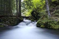
View of a small waterfall on the Dread and Terror Section of the North Umpqua Trail | |
| Length | 79 mi (127 km) |
| Location | Douglas County, Oregon, United States |
| Trailheads |
Swiftwater Wright Creek Mott Panther Calf Marsters Soda Springs Toketee Lake Hot Springs White Mule Kelsay Valley Digit Point |
| Use |
Hiking Horse riding Mountain Biking |
| Elevation | |
| Elevation change | 4,200 ft (1,300 m) |
| Highest point | Maidu Lake, 6,000 ft (1,800 m) |
| Lowest point | Swiftwater Trailhead |
| Hiking details | |
| Trail difficulty | Easy to Difficult |
| Months |
Lower Sections Open Year Round Upper Sections Late April to Late September |
| Sights |
North Umpqua River Cascade Range |
| Hazards |
Severe Weather Dehydration Wildlife Poison Oak |
The North Umpqua Trail is a multi-use trail open for hiking, mountain biking and horse-back riding that follows the North Umpqua River in Southern Oregon, United States. The trail is about 79 miles (127 km) long. It is broken up into 11 sections, ranging from 3.5 to 15.7 miles (25.3 km) in length. The trail ranges in elevation from 800 feet (240 m) to about 6,000 feet (1,800 m).[1]
Route
The North Umpqua Trail follows the North Umpqua River as it winds west out of the Cascades and towards the city of Roseburg, Oregon. The trail is inside the Umpqua National Forest and closely follows the river most for most of its length. The trail almost completely avoids all human structures, except at one of the trailheads.
| point | coord | notes |
|---|---|---|
| Swiftwater County Park | 43°19′40″N 123°00′13″W / 43.32764°N 123.00353°WCoordinates: 43°19′40″N 123°00′13″W / 43.32764°N 123.00353°W | western end, near Deadline Falls |
| Fern Creek Falls | 43°19′09″N 122°59′21″W / 43.31909°N 122.98924°W | bridge creek crossing with view of falls and North Umpqua |
| Bob Butte flank | 43°17′52″N 122°57′17″W / 43.29776°N 122.95461°W | highest point on Bob Butte, elevation approx. 1700 ft of 2300+ |
| east end of Tioga segment | 43°19′31″N 122°47′41″W / 43.32536°N 122.79462°W | joins Mott segment |
| Maidu Lake | 43°15′18″N 121°59′59″W / 43.255°N 121.99972°W | eastern end, near Pacific Crest Trail |
References
- ↑ "North Umpqua Trail" (PDF). Bureau of Land Management. Retrieved December 19, 2012.
External links
This article is issued from Wikipedia - version of the Wednesday, March 12, 2014. The text is available under the Creative Commons Attribution/Share Alike but additional terms may apply for the media files.
