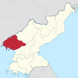
North Pyongan Province
North Pyongan Province (Phyŏnganbukto) is a province of North Korea. The province was formed in 1896 from the northern half of the former P'yŏng'an Province, remained a province of Korea until 1945, then became a province of North Korea. Its capital is Sinŭiju. In 2002, Sinŭiju Special Administrative Region—near the city of Sinuiju—was established as a separately governed Special Administrative Region.
Geography
The Yalu River forms the northern border with China. The province is also bordered on the east by Chagang Province and on the south by South Pyong'an Province. Sinŭiju Special Administrative Region (Sinŭiju T'ŭkpyŏl Haengjŏnggu) is located in the western corner of the province, and was created as an administrative entity separate from North P'yŏngan in 2002. North P'yŏngan is bounded by water on the west with Korea Bay and the Yellow Sea (called the West Sea by Koreans).
Administrative divisions
North P'yŏngan is divided into 3 cities ("Si") and 22 counties ("Kun").
Cities
Counties
Gallery

References


