Nobber
| Nobber An Obair | |
|---|---|
| Village | |
|
Keogan's Bar in the centre of Nobber village | |
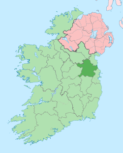
 Nobber Location in Ireland | |
| Coordinates: 53°49′16″N 6°44′48″W / 53.821128°N 6.746678°WCoordinates: 53°49′16″N 6°44′48″W / 53.821128°N 6.746678°W | |
| Country | Ireland |
| Province | Leinster |
| County | County Meath |
| Elevation | 56 m (184 ft) |
| Population (2006) | |
| • Urban | 652 |
| Irish Grid Reference | N812880 |
Nobber (Irish: an Obair, meaning "the work" – referring to a moat around a Norman castle)[1] is a village in north County Meath, Ireland.The village is built near a river called the Dee (from Irish Abha Fherdiea, meaning "river of Ferdia") and near Whitewood Lake which is situated in the town land of Whitewood. It is on the Navan–Kingscourt road (R162) about 12 miles (19 km) north of Navan. This places the village about 37 miles (60 km) from the M50 motorway ; the orbital motorway of Dublin. The town of Kells is to the west and the town of Ardee to the east and the town of Kingscourt is to the north. Villages that border the parish are Kilmainhamwood, Moynalty and Kilbeg to the west, Castletown to the south and Drumconrath and Lobinstown to the east.
History
The Normans were the first known people to settle at Nobber. It acted as a strong point on the road from the ports of Drogheda and Dundalk to the midlands. The Lordship of Meath was granted to Hugh De Lacy by King Henry II of England in 1172 in his capacity as Lord of Ireland. De Lacy granted the Barony of Morgallion to Gilbert de Angulo, who constructed a moate and bailey there. Recently several high crosses were discovered in the village's old cemetery (St Johns) dating from possibly the 10th century. These are much smaller and less ornate than typical Celtic high crosses. This find is significant because it suggests that a hitherto unrecorded monastic settlement once existed on the site of the village. Moynagh Lake west of the village is the site of a multi-period crannog which dates to Mesolithic times. In the Medieval period Nobber was the chief town of the Barony of Morgallion.
Transport
Rail
A disused railway line dating from 1875 runs through the village which runs from Kingscourt to Navan. This was purchased by the Midland Great Western Railway in 1888. Until recent years it operated to haul gypsum from Saint-Gobain Gypsum Industries plant in County Cavan to the port of Drogheda. Nobber railway station opened on 1 November 1872, closed for passenger traffic on 27 January 1947 and finally closed altogether on 1 April 1963.[2]
Bus
Bus Éireann route 107 links Nobber to Navan and Kingscourt.[3] Sillan also provide a link to Navan and Dublin with some buses extending to University College Dublin. In the other direction Sillan services provide a link to Kingscourt, Shercock and Cootehill.[4]
Amenities
- The village has two schools: Nobber National school for primary school children and O'Carolan College which is a comprehensive secondary school.
- The church of Saint John the Baptist is the Roman Catholic church in the centre of the village which also has a fire station, Garda Síochána (police) station.
- Turlough O'Carolan, blind harpist reputed to have been born in Nobber - there is a statue in memory of him at the southern end of the village
- Nobber is also known for having two of the best footballers in Ireland that have represented Meath footballers in the past: Gerry McEntee and also Brian Farrell who currently represents Meath
- Shane McEntee (1956–2012), Fine Gael TD and Minister of State
- George Eogan, archaeologist known for his work at Knowth
Geographic Location
 |
Kilmainhamwood | Kingscourt | Drumconrath |  |
| Moynalty | |
Drumconrath | ||
| ||||
| | ||||
| Kells | Navan | Castletown |
Town Lands
Nobber has 22 townlands. They are:
- Altmush, Arrigal,
- Brittas,
- Cloughmacoo, College, Cregg, Cruicetown,
- Garmanagh,
- Hennigan,
- Julianstown,
- Kilbride,
- Leafin,
- Moydorragh, Moynagh, Muff,
- Newtown, Nobber,
- Possexstown,
- Rathe, Rathgillen,
- Seller, Spiddal.
Cruicetown is the largest townland and Leafin is the smallest.
Sport
- Nobber has only one Gaelic Football team called Nobber G.F.C. In 2003, Nobber won the All-Ireland Junior Club Football Championship, beating Kilmeena of Mayo. Nobber are reigning Meath Intermediate football Champions. Nobber are currently in the Meath Senior Football Championship, which they have never won. Nobber's main Gaelic Football rival is Kilmainhamwood G.F.C. The Nobber colours are black and amber.
- The local soccer team are Electro Celtic FC who are currently in Division 3B of the Meath and District League.
Festivals and Events
The Nobber Fair Day is an annual event that is held on the third Sunday of May. The current event has been running since 2006 reviving an old tradition of a fair that was held in the village for centuries. With an unrivalled collection of rare breeds of farm animals on display the competition for rosettes and prizes across all categories is particularly tough. As this is a genuine fair day, you can expect to find a wide range of activities and attractions including a Vintage Rally, local artisan products and crafts and amusements and entertainment for all the family. Nobber Fair Day will give you an insight into rural life past and present and the opportunity to enjoy a warm and friendly Irish welcome. In 2012, more than 10,000 people attended Nobber Fair Day.
See also
References
- ↑ "Odd and Unusual Irish Place Names". DoChara. Archived from the original on 2008-06-14. Retrieved 2008-07-07.
- ↑ "Nobber station" (PDF). Railscot - Irish Railways. Retrieved 2007-11-22.
- ↑ http://www.buseireann.ie/pdf/1318429076-107.pdf
- ↑ http://sillan.ie/index.php/bus-timetables

