Nishiki, Kumamoto
| Nishiki 錦町 | ||
|---|---|---|
| Town | ||
|
Higo-nishinomura station front | ||
| ||
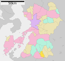
 Location of Nishiki in Kumamoto Prefecture | ||
 Nishiki Location in Japan | ||
| Coordinates: 32°12′N 130°50′E / 32.200°N 130.833°ECoordinates: 32°12′N 130°50′E / 32.200°N 130.833°E | ||
| Country | Japan | |
| Region | Kyushu | |
| Prefecture | Kumamoto Prefecture | |
| District | Kuma | |
| Area | ||
| • Total | 84.87 km2 (32.77 sq mi) | |
| Population (2003) | ||
| • Total | 11,904 | |
| • Density | 140/km2 (360/sq mi) | |
| Time zone | Japan Standard Time (UTC+9) | |
| Website |
www | |
Nishiki (錦町 Nishiki-machi)[lower-alpha 1] is a town located in Kuma District (also known as Kuma County), Kumamoto Prefecture, Japan. The town's name is the Japanese word for "brocade", and is used as a name for more than one town in Japan. The town can trace it's origin back to the merger of three villages in 1884. Two more villages (Ichibu and Kijo) were merged with Nishiki, then known as Nishi-mura or "West village", in 1955. It formally gained it's status as a town (町; chō or machi) on April 1st, 1965. At one time, between 1985 and 2006, Nishiki was twinned with the (now defunct) town of Nishiki, Yamaguchi.
In 2003 the town had an estimated population of 11,904 and a density of 140.26 persons per km². The total area is 84.87 km2 (32.77 sq mi). Nishiki is served by the Higo-Nishinomura Station of the Kumagawa Railroad Yunomae Line.
Flag
The current town flag was adopted in 1956, however there is no formal flag law codifying this.[1] The flag is green with a town emblem in the center. The emblem is a stylized katakana ニNi of Nishiki. The circle "symbolizes a reconciliation and the mountain, the river and the sun do the town located in the center of Kuma Basin which is expanding to the future".[1]
Geography
Nishiki is located in the southern part of Kumamoto prefecture. 70 kilometers (43.5 miles) South-southeast of the town is the prefectural capital. The northern portion of the town lies in flat terrain that forms part of the Hitoyoshi Basin; the Kuma River borders the town to the East and West. The southern reaches of the Kuju mountain range (九重山, Kujūsan)[lower-alpha 2] adjoins one corner of the town limits. The southern most corner of the townsland meets the prefectural border with Miyazaki Prefecture.
Economy
The town's economy is primarily based around agriculture (primarily pear, peach and rice cultivation) and leisure tourism activities such as golf holidays, though the Nishiki plant of Renesas Semiconductor (formerly NEC Kumamoto) is also a major contributor. The Nishiki plant specializes in LSI manufacturing. The total economic output of Nishiki for fiscal year 2004 was ¥40.7 billion yen.
World War II
During the closing years of the Second World War, a major base of the Imperial Japanese Navy's Hitoyoshi Naval Air Group was located near the town.[2] Relatively little is currently known about the base and it's operations due to a loss of records and institutional memory both during and after the war; The remains of the base extends over 36,000 m2 (390,000 sq ft) of land, and houses underground facilities in more than 10 locations, including an operations room and a large torpedo preparation area.[2] In 2015, a full archeological survey of the site was initiated by the municipal government via the Nishiki board of education to discover more about the base and it's past, with a view to eventually opening it up to tourism.[2] This followed the discovery by the local government of a copy of a floor plan for the base.
See also
- Imperial Japanese Navy Air Service
- Imperial Japanese Navy Aviation Bureau
- Japanese Home Islands campaign
- Hitoyoshi, Kumamoto
- Torpedo bomber
- Imperial Japanese Army Railways and Shipping Section
Notes
- ↑ In some translations, especially machine based, the name is translated as Nishikicho (Nishiki-cho).
- ↑ Some machine translations give this as 'Kyushusanchi'.
References
- 1 2 Nishiki Town (Kumamoto prefecture, Japan) 錦町 - Flags of the World
- 1 2 3 MIYASHIRO, EIICHI (2 February 2016), "Archaeologists dig up answers in new study on remnants from World War II", The Asahi Shimbun, retrieved 2 February 2016
External links
 Media related to Nishiki, Kumamoto at Wikimedia Commons
- Nishiki official website (Japanese)
- 熊本県の市町村旗一覧 (Municipality Flag List of Kumamoto Prefecture) Japanese Wikipedia (Japanese)
|

