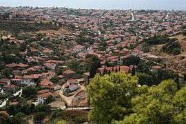
Nikiti
| Nikiti Νικήτη | |
|---|---|
|
Panorama of Nikiti | |
 Nikiti | |
| Coordinates: 40°12.58′N 23°40.43′E / 40.20967°N 23.67383°ECoordinates: 40°12.58′N 23°40.43′E / 40.20967°N 23.67383°E | |
| Country | Greece |
| Administrative region | Central Macedonia |
| Regional unit | Chalkidiki |
| Municipality | Sithonia |
| Municipal unit | Nikiti |
| Community | |
| Time zone | EET (UTC+2) |
| • Summer (DST) | EEST (UTC+3) |
| Postal code | 63088 |
Nikiti (Greek: Νικήτη) is a village located 100 kilometers south-east from Thessaloniki on the Chalkidiki peninsula in Macedonia, Greece. It is the seat of the municipal unit of Sithonia.
The old part of Nikiti is located on the hilly area a few hundred meters from the sea, with a church at the highest point of the village. In the 1950s the village started to expand downwards to the coast significantly. In the 1970s the coastal plain was included into plans for village's development and many new buildings were built there.[1]
The most important economic sector in Nikiti is tourism. Other important economic activities in Nikiti are beekeeping and olive growing.
Tourism
Chalkidiki is popular summer tourist destination since the late 1950s when people from Thessaloniki started spending their summer holidays at the coastal villages like Nikiti. At the beginning tourists rented rooms in the houses of the villagers. By the 1970s tourists from Austria and Germany started to visit Chalkidiki more frequently. In the 1980s the big tourist boom started.[2]
Gallery
-
House in Nikiti.
-
House in Nikiti.
-

Nikiti port by night.
References
External links
- History of Nikiti
 Media related to Nikiti at Wikimedia Commons
| ||||||||||
