Niiza, Saitama
| Niiza 新座市 | ||
|---|---|---|
| City | ||
| ||
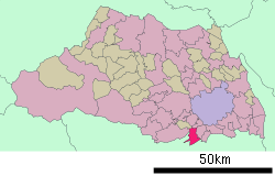
 Location of Niiza in Saitama Prefecture | ||
 Niiza Location in Japan | ||
| Coordinates: 35°48′N 139°34′E / 35.800°N 139.567°ECoordinates: 35°48′N 139°34′E / 35.800°N 139.567°E | ||
| Country | Japan | |
| Region | Kantō | |
| Prefecture | Saitama Prefecture | |
| Government | ||
| • Mayor | Kenji Suda (since July 1992) | |
| Area | ||
| • Total | 22.80 km2 (8.80 sq mi) | |
| Population (2010) | ||
| • Total | 159,741 | |
| • Density | 6.602/km2 (17.10/sq mi) | |
| Symbols | ||
| • Tree | Acer palmatum | |
| • Flower | magnolia kobus | |
| Time zone | Japan Standard Time (UTC+9) | |
| City Hall Address |
1-1-1 Nohitome 352-8623 | |
| Website |
www | |
Niiza (新座市 Niiza-shi) is a city located in Saitama Prefecture, Japan, and is essentially a suburb of the Tokyo conurbation. Niiza is located at the southernmost part of Saitama.The city was founded on November 1, 1970.[1]
As of 2010, the city has an estimated population of 159,741 and a population density of 7,010 persons per km². The total area is 22.80 km².
Geography

Niiza is home to Heirin-ji, a large Rinzai Zen Buddhist temple. The temple is located in Nobidome, close to Niiza City Hall. There is a very large stone gate (野火止大門 "Nobidome Daimon") along National Road 254, which runs through the middle of the city.
On April 7, 2003, Niiza gave the anime character Astro Boy an honorary citizenship to mark the date given as his birthdate in the original manga.
Transportation
The Seibu Ikebukuro Line crosses the southern part of Niiza and shares the Hibarigaoka Station with Nishitōkyō, the JR Musashino Line goes into the main area of Niiza at Niiza Station including a separate station for freight service and the Tōbu Tōjō Line provides service to the northern area of Niiza via Shiki Station, which despite the name is located in Niiza and not neighbouring Shiki.
International relations
Twin towns — Sister cities
Niiza is twinned with:
-
 Jyväskylä, Finland (1997)
 -
 Nasushiobara, Tochigi, Japan (2000)
 -
 Tōkamachi, Niigata, Japan (2002)
 -
 Jiyuan, China (2002)
 -
 Neuruppin, Germany (2003)
References
External links
| Wikimedia Commons has media related to Niiza, Saitama. |
- Niiza City official website (Japanese)
| |||||||||||||||||||||||||
|