Nerima
| Nerima 練馬区 | ||
|---|---|---|
| Special ward | ||
| Nerima City | ||
|
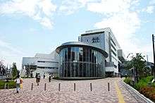
A street in Hikarigaoka, Nerima | ||
| ||
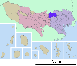 Location of Nerima in Tokyo | ||
 Nerima Location in Japan | ||
| Coordinates: 35°44′8.24″N 139°39′5.97″E / 35.7356222°N 139.6516583°ECoordinates: 35°44′8.24″N 139°39′5.97″E / 35.7356222°N 139.6516583°E | ||
| Country | Japan | |
| Region | Kantō | |
| Prefecture | Tokyo | |
| Area | ||
| • Total | 48.16 km2 (18.59 sq mi) | |
| Population (2010-04-01) | ||
| • Total | 713,995 | |
| • Density | 14,443/km2 (37,410/sq mi) | |
| Symbols | ||
| • Tree | Kobushi Magnolia | |
| • Flower | Azalea | |
| Time zone | Japan Standard Time (UTC+9) | |
| City Hall Address |
6-12-1 Toyotama-kita, Nerima 176-8501 | |
| Website |
www | |


Nerima (練馬区 Nerima-ku) is a special ward in Tokyo, Japan. In English, it calls itself Nerima City.
As of 1 August 2007, the ward has an estimated population of 703,005, with 323,296 households and a population density of 14,443 persons per km². 12,897 foreign residents are registered in the ward. 18.4% of the ward's population is over the age of 65. The total area is 48.16 km².
History
In the Edo period, the area was mostly farmland producing daikon radishes, gobo burdocks, and potatoes. After the 1923 Great Kantō earthquake, many people from central Tokyo moved to the area.[1]
In October 1, 1932, Nerima town, and Kami-Nerima, Naka-Arai, Shakujii and Ōizumi Villages were incorporated in Old Tokyo City. Prior to the creation of the ward on August 1, 1947, the area had been part of Itabashi. In 1952, the Japan Self-Defense Forces established a base there. The first division of the eastern group of the Ground Self-Defense Force has its headquarters there. The United States Forces Japan already had a base, Grant Heights, which it returned to Japanese control in 1973. Grant Heights had been Narimasu airfield under the Imperial Japanese Army until the end of World War II. The runway is now the main street in front of the IMA department store in Hikarigaoka.
Geography

Nerima lies at the northwestern edge of the 23 special wards of Tokyo. Its neighbors are the special wards of Itabashi (to the east), Suginami, Toshima and Nakano (to the south), as well as the cities of Musashino (to the southwest) and Nishi-Tokyo (to the west). To the north lie three cities in Saitama Prefecture: Wako, Asaka and Niiza.
Economy
Toei Animation has its headquarters in the Ohizumi Studio in Nerima.[2] Anime International Company has its headquarters in the AIC Digital Building.[3] In addition, Studio Comet,[4] and Mushi Production have their headquarters in Nerima.[5]
Education
Public schools
- 69 elementary schools are operated by the Nerima City Board of Education
- 34 junior high schools are operated by the Nerima City Board of Education
- 10 high schools are operated by the Tokyo Metropolitan Government Board of Education
High schools
- Fourth Commercial High School
- Hikarigaoka High School
- Igusa High School
- Nerima High School
- Nerima Technical High School
- Oizumi High School
- Oizumi Gakuen High School
- Oizumi Sakura High School
- Shakujii High School
- Tagara High School
National schools
- Oizumi elementary school attached to Tokyo Gakugei University
- Oizumi junior high school attached to Tokyo Gakugei University
- Tokyo Gakugei University senior high school
Private schools
- One elementary school
- Three junior high schools
- Four high schools
Colleges and universities
- Musashino Academia Musicae
- Musashi University
- Nihon University Ekoda Campus
- Sophia University Shakujii Campus: Faculty of Theology
International Schools
- Aoba-Japan International School
Transportation
Rail

- Tokyo Metro
- Yūrakuchō Line: Kotake Mukaihara, Hikawadai, Heiwadai, Chikatetsu Akatsuka Stations
- Fukutoshin Line: Kotake Mukaihara, Hikawadai, Heiwadai, Chikatetsu Akatsuka Stations
- Tokyo Metropolitan Bureau of Transportation
- Ōedo Line: Shin-egota (on the boundary with Nakano), Nerima, Toshimaen, Nerima-kasugachō, Hikarigaoka Stations

- Seibu Railway
- Ikebukuro Line: Ekoda, Sakuradai, Nerima, Nakamurabashi, Fujimidai, Nerima-Takanodai, Shakujii-kōen, Ōizumi-gakuen Stations
- Shinjuku Line: Kami-Shakujii, Musashi-Seki Stations
- Toshima Line: Nerima, Toshimaen Stations
- Yūrakuchō Line: Kotake Mukaihara, Shin-Sakuradai, Nerima Stations
- Tobu Railway
- Tōjō Line: Tōbu-Nerima and Shimo-Akatsuka Stations are on the boundary with Itabashi
Bus
- Kanto Bus
- Keio Bus: The Chu 92 bus travels between Nerima and Nakano Stations
- Kokusai-Kogyo Bus
- Seibu Bus
- Toei Bus: The Bus Service Division of the Tokyo Metropolitan Bureau of Transportation operates 5 routes in Nerima Ward.
Road
- Expressways:
- National highways:
- National Route 17 (Shin Ōmiya Bypass)
- National Route 254 (Kawagoe Kaidō)
- Other major roads:
- Shin-Ōme Kaidō (Prefectural Road 245)
- Mejiro Dōri (Prefectural Road 8)
- Hoya Kaidō (Prefectural Road 233)
- Kan-nana (Prefectural Road 318)
- Kan-pachi (Prefectural Road 311)
- Nakasugi Dōri (Prefectural Road 427)
- Senkawa Dōri (Prefectural Road 439)
- Fuji Kaidō (Prefectural Road 441)
- Sasame Dōri (Prefectural Road 443&68)
- Igusa Dōri (Prefectural Road 444)
Leisure
Amusement parks
Museums
- Ward art museum
- Iwasaki Chihiro illustrated book museum
Parks

- Hikarigaoka Park
- Shakujii Park
- Ōizumi Central Park
- Musashiseki Park
- Jōhoku Central Park (on the boundary with Itabashi)
Media
Nerima prepares the Nerima News Azalea, a city newsletter, in English.[6]
Other
- Japan Ground Self-Defense Force Nerima Base
International relations
Nerima has a sister-city relationship with Ipswich, Queensland, Australia. Nerima Gardens in Ipswich commemorates the tie. Nerima also has a similar link to Haidian District, Beijing, China.
See also
References
- ↑ http://www.city.nerima.tokyo.jp/kocho_koho/koho/publication/file/file01.pdf
- ↑ "Outline." Toei Animation. Retrieved on February 26, 2010.
- ↑ "Company Profile." Anime International Company. Retrieved on February 26, 2010. "AIC Digital Bldg. 3-19-9 Nakamura Kita, Nerima-Ku, Tokyo, Japan 176-0023"
- ↑ "company (会社案内)." Studio Comet. Retrieved on March 15, 2012. "〒176-0013 東京都練馬区豊玉中3-1-3"
- ↑ Home. Mushi Production. Retrieved on March 15, 2012. "〒177-0034 東京都練馬区 富士見台2-30-5"
- ↑ http://www.city.nerima.tokyo.jp/kuho_gaikokugo/2006_10_5/english.pdf
External links
| Wikimedia Commons has media related to Nerima, Tokyo. |
- Official website (Japanese)
- Nerima Animation Conference (Japanese) and (English)
- Nerima Gardens page at Ipswich City Council site
| ||||||||||||||||||||||||||||||||||||||||||||||||
|