Republic of Negros
| Cantonal Republic of Negros Republic of Negros | |||||
| República Cantonal de Negros República de Negros Republica Cantonal sang Negros Republica sang Negros | |||||
| US Protectorate (1899-1901) | |||||
| |||||
|
| |||||
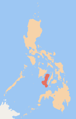
 Location of Negros in the Philippines | |||||
| Capital | Bacolod | ||||
| Languages | Hiligaynon, Cebuano and Spanish | ||||
| Government | Republic | ||||
| President (from 1899-1901, Governor) | Aniceto Lacson 1898-1899 | ||||
| Melecio Severino (as Governor) 1899-1901 | |||||
| Legislature | Chamber of Deputies | ||||
| Historical era | New Imperialism | ||||
| • | End of the Negros Revolution | November 27, 1898 | |||
| • | Disestablished | April 30, 1901 | |||
| Today part of | Negros Island Region, | ||||
| | |||||
Part of a series on the |
|---|
| History of the Philippines |
 |
| Timeline |
| Philippines portal |
The Republic of Negros (Spanish: República de Negros, Hiligaynon: Republica sang Negros) was a short-lived revolutionary republic, and later, administrative division, which existed while the Philippines was under Spanish and American sovereignty. It took its name from Negros Island.
History
From 3 November to 6 November 1898, the people of Negros rose in revolt against the Spanish authorities headed by politico-military governor, colonel Isidro de Castro. The Spaniards decided to surrender upon seeing armed troops marching in a pincer movement towards main city Bacolod. The revolutionaries, led by generals Juan Araneta, from Bago, and Aniceto Lacson, from Talisay, were actually carrying fake arms consisting of rifles carved out of palm fronds and cannons of rolled bamboo mats painted black. By the afternoon of 6 November, colonel de Castro signed the Act of Capitulation, thus ending Spanish colonial rule in Negros Occidental.
On November 27, 1898, the unicameral Chamber of Deputies (Spanish: Cámara de Diputados) met in Bacolod and declared the establishment of the Cantonal Republic of Negros (Spanish: República Cantonal de Negros). The Chamber of Deputies acted as a Constituent Assembly to draft a constitution.
When the invasion of the United States Army was looming, President Aniceto Lacson raised the American flag in the Casa Real to welcome the army as a friendly force. Despite the initial protest from the Negros Oriental deputies, the republic came under U.S. protection on April 30, 1899 as a separate state from the rest of the Philippine Islands and on the next day, the constitution was passed. On 22 July 1899, it was renamed the Republic of Negros, but on 30 April 1901, it was dissolved and annexed to the Philippine Islands by the United States, who retained control until the Japanese imperial occupation in the Second World War.
Republican Leaders
The leaders of the short-lived republic were:[3]
Aniceto Lacson
(November 5, 1898 - November 27, 1898)
November 5, 1898 - July 22, 1899
(President in Negros Occidental only until November 27, 1898)
PresidentDemetrio Larena
(November 24, 1898 - November 27, 1898)
November 5, 1898 - July 22, 1899
(President in Negros Oriental only)
Vice-PresidentJosé Luzuriaga
July 22, 1899 - November 6, 1899President of the Chamber of Deputies Eusebio Luzurriaga Secretary of the Treasury Simeon Lizares Secretary of the Interior Nicolas Golez Secretary of Public Works Agustin Amenablar Secretary of Agriculture and Commerce Juan Araneta Secretary of War Antonio Ledesma Jayme
July 24, 1854 - October 9, 1937Secretary of Justice Melecio Severino
November 6, 1899 - April 30, 1901Civil Governor
Commemoration
In Bago City, the event was chronicled in a historic marker found in the Public Plaza, which bears the following inscriptions:
| “ |
REPÚBLICA DE NEGROS |
” |
5 November has been observed as a special non-working holiday in Negros Occidental through Republic Act № 6709, signed by President Corazon Aquino on 10 February 1989.
See also
External links
Sources and References
- ↑ "The Two Republics of Negros". Retrieved 26 October 2012.
- ↑ "What is the República Negrénse?". Retrieved 27 September 2013.
- ↑ WorldStatesmen. "Philippines - Republic of Negros". Retrieved 10 August 2010.
Coordinates: 10°N 123°E / 10°N 123°E
| ||||||||||||||||||||||
