National Register of Historic Places listings in Southampton County, Virginia

Location of Southampton County in Virginia
This list includes properties and districts listed on the National Register of Historic Places in Southampton County, Virginia. Click the "Map of all coordinates" link to the right to view a Google map of all properties and districts with latitude and longitude coordinates in the table below.[1]
- This National Park Service list is complete through NPS recent listings posted February 19, 2016.[2]
| [3] |
Name on the Register[4] |
Image |
Date listed[5] |
Location |
City or town |
Description |
|---|
| 1 |
Aspen Lawn |
Upload image |
000000002002-04-01-0000April 1, 2002
(#02000319) |
4438 Hicksford Rd.
36°39′53″N 77°26′11″W / 36.664722°N 77.436389°W / 36.664722; -77.436389 (Aspen Lawn) |
Drewryville |
|
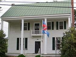
| 2 |
Beaton-Powell House |
Upload image |
000000002008-11-14-0000November 14, 2008
(#08001058) |
32142 South Main St.
36°35′05″N 77°12′02″W / 36.584608°N 77.200581°W / 36.584608; -77.200581 (Beaton-Powell House) |
Boykins |
|
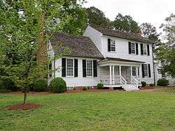
| 3 |
Beechwood |
Upload image |
000000001979-02-01-0000February 1, 1979
(#79003088) |
NE of Courtland on VA 643
36°45′10″N 77°00′06″W / 36.752778°N 77.001667°W / 36.752778; -77.001667 (Beechwood) |
Beales |
|
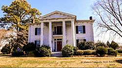
| 4 |
Belmont |
Upload image |
000000001973-10-03-0000October 3, 1973
(#73002061) |
Northeast of Capron off VA 652
36°43′37″N 77°10′17″W / 36.726944°N 77.171389°W / 36.726944; -77.171389 (Belmont) |
Capron |
|
| 5 |
Brown's Ferry |
Upload image |
000000001979-06-18-0000June 18, 1979
(#79003090) |
East of Drakes Corner off VA 684
36°36′37″N 77°00′04″W / 36.610278°N 77.001111°W / 36.610278; -77.001111 (Brown's Ferry) |
Drakes Corner |
|
| 6 |
Elm Grove |
|
000000001979-07-24-0000July 24, 1979
(#79003089) |
Northeast of Courtland on VA 646
36°44′39″N 77°01′41″W / 36.744167°N 77.028056°W / 36.744167; -77.028056 (Elm Grove) |
Courtland |
|
| 7 |
Mahone's Tavern |
|
000000002008-05-29-0000May 29, 2008
(#08000483) |
22341 Main St.
36°42′50″N 77°04′01″W / 36.713856°N 77.067°W / 36.713856; -77.067 (Mahone's Tavern) |
Courtland |
Childhood home of Confederate General William Mahone[6]
|
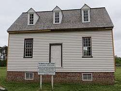
| 8 |
Rochelle-Prince House |
|
000000002011-01-07-0000January 7, 2011
(#10001115) |
22371 Main St.
36°42′47″N 77°03′59″W / 36.713056°N 77.066389°W / 36.713056; -77.066389 (Rochelle-Prince House) |
Courtland |
James Rochelle was clerk of the Southampton County court during the trial of Nat Turner. His nephew was George Henry Thomas, a Union general in the American Civil War.[6]
|
| 9 |
Rose Hill |
Upload image |
000000001979-12-31-0000December 31, 1979
(#79003087) |
Northeast of Capron on VA 635
36°44′42″N 77°08′06″W / 36.745°N 77.135°W / 36.745; -77.135 (Rose Hill) |
Capron |
|
| 10 |
Sebrell Rural Historic District |
Upload image |
000000002013-08-27-0000August 27, 2013
(#13000648) |
Roughly bounded by Nottoway R., Assamoosick Swamp & Old Hickory Rd.
36°47′10″N 77°07′36″W / 36.786148°N 77.12673°W / 36.786148; -77.12673 (Sebrell Rural Historic District) |
Sebrell vicinity |
|
| 11 |
Simmons-Sebrell-Camp House |
Upload image |
000000002003-10-23-0000October 23, 2003
(#03001097) |
Zebulon Simmons Tract
36°47′13″N 77°07′52″W / 36.786944°N 77.131111°W / 36.786944; -77.131111 (Simmons-Sebrell-Camp House) |
Courtland |
|
| 12 |
Sunnyside |
|
000000001982-07-08-0000July 8, 1982
(#82004596) |
VA 673
36°38′40″N 77°08′34″W / 36.644444°N 77.142778°W / 36.644444; -77.142778 (Sunnyside) |
Newsoms |
|
| 13 |
Rebecca Vaughan House |
|
000000002006-03-22-0000March 22, 2006
(#06000162) |
26315 Heritage Ln.
36°42′39″N 77°03′29″W / 36.710833°N 77.058056°W / 36.710833; -77.058056 (Rebecca Vaughan House) |
Courtland |
The last house in which anyone was killed during the Southampton Insurrection of 1831
|
| 14 |
William H. Vincent House |
Upload image |
000000002004-01-16-0000January 16, 2004
(#03001444) |
23016 Main St.
36°42′29″N 77°12′03″W / 36.708056°N 77.200833°W / 36.708056; -77.200833 (William H. Vincent House) |
Capron |
|
See also
References
- ↑ The latitude and longitude information provided in this table was derived originally from the National Register Information System, which has been found to be fairly accurate for about 99% of listings. For about 1% of NRIS original coordinates, experience has shown that one or both coordinates are typos or otherwise extremely far off; some corrections may have been made. A more subtle problem causes many locations to be off by up to 150 yards, depending on location in the country: most NRIS coordinates were derived from tracing out latitude and longitudes off of USGS topographical quadrant maps created under the North American Datum of 1927, which differs from the current, highly accurate WGS84 GPS system used by most on-line maps. Chicago is about right, but NRIS longitudes in Washington are higher by about 4.5 seconds, and are lower by about 2.0 seconds in Maine. Latitudes differ by about 1.0 second in Florida. Some locations in this table may have been corrected to current GPS standards.
- ↑ "National Register of Historic Places: Weekly List Actions". National Park Service, United States Department of the Interior. Retrieved on February 19, 2016.
- ↑ Numbers represent an ordering by significant words. Various colorings, defined here, differentiate National Historic Landmarks and historic districts from other NRHP buildings, structures, sites or objects.
- ↑ Staff (2008-04-24). "National Register Information System". National Register of Historic Places. National Park Service.
- ↑ The eight-digit number below each date is the number assigned to each location in the National Register Information System database, which can be viewed by clicking the number.
- 1 2 "Southampton County, Virginia: History". Southampton County, Virginia. Retrieved 26 April 2013.
|
|---|
| Lists
by county | | |
|---|
| Lists
by city | |
|---|
| | Other lists | |
|---|
| |
|