National Register of Historic Places listings in Essex County, Virginia
Location of Essex County in Virginia
This list includes properties and districts listed on the National Register of Historic Places in Essex County, Virginia. Click the "Map of all coordinates" link to the right to view a Google map of all properties and districts with latitude and longitude coordinates in the table below.[1]
- This National Park Service list is complete through NPS recent listings posted February 19, 2016.[2]
| [3] |
Name on the Register[4] |
Image |
Date listed[5] |
Location |
City or town |
Description |
|---|
| 1 |
Blandfield |
|
000000001969-11-12-0000November 12, 1969
(#69000238) |
E of jct. of Rtes. 624 and U.S. 17
37°59′34″N 76°56′43″W / 37.992778°N 76.945278°W / 37.992778; -76.945278 (Blandfield) |
Caret |
|
| 2 |
Brooke's Bank |
|
000000001971-09-28-0000September 28, 1971
(#71000976) |
1 mi. E of Loretto, 1.4 mi. N of VA 17
38°05′11″N 77°01′13″W / 38.086389°N 77.020278°W / 38.086389; -77.020278 (Brooke's Bank) |
Loretto |
|
| 3 |
Cherry Walk |
Upload image |
000000001983-02-10-0000February 10, 1983
(#83003280) |
S of Dunbrooke on VA 620
37°51′38″N 76°57′06″W / 37.860556°N 76.951667°W / 37.860556; -76.951667 (Cherry Walk) |
Dunbrooke |
|
| 4 |
Elmwood |
|
000000001970-09-15-0000September 15, 1970
(#70000790) |
SW of jct. of Rtes. 640 and U.S. 17
38°05′16″N 77°05′31″W / 38.087778°N 77.091944°W / 38.087778; -77.091944 (Elmwood) |
Loretto |
|
| 5 |
Glebe House of St. Anne's Parish |
|
000000001975-03-03-0000March 3, 1975
(#75002020) |
2.5 mi. NE of Champlain on N bank of Farmers Hall Creek
38°02′00″N 76°57′38″W / 38.033333°N 76.960556°W / 38.033333; -76.960556 (Glebe House of St. Anne's Parish) |
Champlain |
|
| 6 |
Glencairn |
Upload image |
000000001979-05-14-0000May 14, 1979
(#79003036) |
N of Chance off U.S. 17
38°03′54″N 77°00′43″W / 38.065°N 77.011944°W / 38.065; -77.011944 (Glencairn) |
Chance |
|
| 7 |
Linden |
Upload image |
000000001992-10-15-0000October 15, 1992
(#92001397) |
US 17 SW side, 0.5 mi. S of Champlain
38°00′19″N 76°59′13″W / 38.005278°N 76.986944°W / 38.005278; -76.986944 (Linden) |
Champlain |
|
| 8 |
Monte Verde |
|
000000002002-05-30-0000May 30, 2002
(#02000586) |
405 Monte Verde Rd.
37°48′23″N 76°46′06″W / 37.806481°N 76.768353°W / 37.806481; -76.768353 (Monte Verde) |
Center Cross |
|
| 9 |
Port Micou |
Upload image |
000000001992-02-06-0000February 6, 1992
(#91002041) |
VA 674, at Rappahannock R.
38°07′22″N 77°03′35″W / 38.122778°N 77.059722°W / 38.122778; -77.059722 (Port Micou) |
Loretto |
|
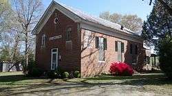
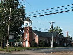
| 10 |
St. Matthew's Church |
|
000000002004-01-16-0000January 16, 2004
(#03001429) |
Jct. of VA 17, Virginia 631, and VA 724
38°00′57″N 76°59′28″W / 38.015833°N 76.991111°W / 38.015833; -76.991111 (St. Matthew's Church) |
Champlain |
|
| 11 |
Tappahannock Historic District |
|
000000001973-04-02-0000April 2, 1973
(#73002009) |
Roughly bounded by Queen St., Church Lane, Rappahannock River and the grounds of St. Margaret's School
37°55′39″N 76°51′31″W / 37.9275°N 76.858611°W / 37.9275; -76.858611 (Tappahannock Historic District) |
Tappahannock |
|
| 12 |
Vauter's Church |
|
000000001972-12-05-0000December 5, 1972
(#72001391) |
1 mi. NW of Loretto on U.S. 17
38°05′12″N 77°04′07″W / 38.086667°N 77.068611°W / 38.086667; -77.068611 (Vauter's Church) |
Loretto |
|
| 13 |
Wheatland |
Upload image |
000000001990-12-19-0000December 19, 1990
(#89001918) |
VA 638 between US 17 and the Rappahanock River
38°05′04″N 77°02′14″W / 38.084444°N 77.037222°W / 38.084444; -77.037222 (Wheatland) |
Loretto |
|
| 14 |
Woodlawn |
Upload image |
000000001980-07-16-0000July 16, 1980
(#80004187) |
NE of Miller's Tavern
37°51′07″N 76°55′11″W / 37.851944°N 76.919722°W / 37.851944; -76.919722 (Woodlawn) |
Miller's Tavern |
|
See also
References
- ↑ The latitude and longitude information provided in this table was derived originally from the National Register Information System, which has been found to be fairly accurate for about 99% of listings. For about 1% of NRIS original coordinates, experience has shown that one or both coordinates are typos or otherwise extremely far off; some corrections may have been made. A more subtle problem causes many locations to be off by up to 150 yards, depending on location in the country: most NRIS coordinates were derived from tracing out latitude and longitudes off of USGS topographical quadrant maps created under the North American Datum of 1927, which differs from the current, highly accurate WGS84 GPS system used by most on-line maps. Chicago is about right, but NRIS longitudes in Washington are higher by about 4.5 seconds, and are lower by about 2.0 seconds in Maine. Latitudes differ by about 1.0 second in Florida. Some locations in this table may have been corrected to current GPS standards.
- ↑ "National Register of Historic Places: Weekly List Actions". National Park Service, United States Department of the Interior. Retrieved on February 19, 2016.
- ↑ Numbers represent an ordering by significant words. Various colorings, defined here, differentiate National Historic Landmarks and historic districts from other NRHP buildings, structures, sites or objects.
- ↑ Staff (2008-04-24). "National Register Information System". National Register of Historic Places. National Park Service.
- ↑ The eight-digit number below each date is the number assigned to each location in the National Register Information System database, which can be viewed by clicking the number.
|
|---|
| Lists
by county | | |
|---|
| Lists
by city | |
|---|
| | Other lists | |
|---|
| |
|
.jpg)
.jpg)
.jpg)
.jpg)
.jpg)

