National Highway 47 (India)(old numbering)
| ||||
|---|---|---|---|---|
|
Road map of India with National Highway 47 highlighted in solid blue color | ||||
| Route information | ||||
| Length: | 620 km (390 mi) | |||
| Major junctions | ||||
| North end: | Salem, Tamil Nadu | |||
|
Coimbatore (NH 67), Coimbatore (NH 209), Palakkad (NH 213), Edapally (NH 17), Kundannoor (NH 49), Kundannoor (NH 47A), Kollam (NH 220), Kollam (NH 208), Nagarcoil (NH 47B) | ||||
| South end: | Kanyakumari, Tamil Nadu | |||
| Location | ||||
| States: |
Kerala: 416 km (258 mi) Tamil Nadu: 224 km (139 mi) | |||
| Primary destinations: | Salem - Coimbatore - Palakkad - Thrissur - Kochi - Alappuzha - Kollam, Thiruvananthapuram - Nagercoil - Kanyakumari | |||
| Highway system | ||||
| ||||

.png)
National Highway 47, commonly referred to as NH 47, is a 620 km (390 mi) long highway connecting the city of Salem to Kanyakumari town in southern India. The highway runs through the states of Kerala and Tamil Nadu.[1] The important towns are Salem, Palakkad, Thrissur, Alappuzha, Kollam, Thiruvananthapuram, Nagercoil and Kanyakumari.[2] The NH 47 runs within a few kilometers of Coimbatore International Airport (within Coimbatore city limits), Cochin International Airport (Nedumbassery) and the Thiruvananthapuram (Trivandrum) International Airport.
The Salem-Coimbatore-Kochi stretch of the highway is included in the North-South Corridor of the Indian highway system. It is currently undergoing conversion to 4 lane, with some sections 6 lane.[3][4] At the end of 2010, 40% of this stretch is 4 laned, and 35% under implementation.
Traffic
The stretch between the Industrial city of Coimbatore and the Port city of Kochi is one of the busiest in the Indian Highway system. Most of the traffic in this stretch comprises trucks carrying consumer goods, construction materials, container lorries (bound for Kochi Port and Kochi International Container Transhipment Terminal) and passenger vehicles. During night, the highway experiences a huge volume of traffic. On an average, around 8,000 lorries use this highway to reach Coimbatore every night. The highway has several motels and restaurants along the entire stretch. Fatal accidents frequently happen in this highway, mostly due to irresponsible bus drivers and over-speeding lorries colliding head on. Many number of Large Industries and Textile parks are located on this highway between Coimbatore, Erode and Tiruppur districts.
Earlier the National Highway-47 which used to pass through the centre of Coimbatore city, now completely bypasses the city, with the commissioning of L&T by-pass road. The arterial Avinashi Road and Palakkad Road in Coimbatore city's stretch from Neelambur to Madukkarai through Ukkadam, Karumbukadai, Attuppalam, Kuniyamuthur has now been transferred to the State Highways Department, and is not part of the NH 47 anymore. In case of any mishaps on the highway, the emergency services are sometimes delayed several hours due to the volume of traffic in the Coimbatore-Salem Industrial Corridor.
Route
Salem, Sankari, Komarapalayam, Bhavani, Chithode (Erode Bypass), Nasiyanur, Perundurai, Vijayamangalam, Chengapalli, Perumanallur(bypass), New Tirupur(Netaji Apparel Park), Avinashi(bypass), Tekkalur, Karumathampatti, Kaniyur, Neelambur (Coimbatore bypass), Madukkarai (Coimbatore Bypass), K.G.Chavadi(bypass), Walayar(Tamil Nadu-Kerala Border), Kanjikode, Chandranagar (Palakkad Bypass), Alathur, Vadakkanchery, Mannuthy (Thrissur Bypass), Chalakkudy, Angamaly, Aluva, Kalamassery, Edapally (Kochi Bypass), Vytilla (Kochi Bypass), Aroor, Vayalar, Cherthala, Alappuzha, Kalarcode, Punnapra, Ambalappuzha, Haripad, Kayamkulam, Oachira, Karunagappally, Kollam, Kottiyam, Mylakkadu, Chathannoor, Kallambalam, Paripalli, Attingal, Kazhakkuttam(Thiruvananthapuram Bypass), Kovalam, Nemom, Balaramapuram, Neyyattinkara, Parassala, (Kerala-Tamil Nadu Border), Kaliyakkavilai, Kuzhithurai, Marthandam,Azhagiamandapam Thuckalay, Parvathipuram, Nagercoil, Kottar, Suchindram and Kanyakumari.[5]
Heavy Traffic

Coimbatore Area
Avinashi - Tekkalur - Karumathampatti - Kaniyur - Arasur - Neelambur (Coimbatore bypass) - Madukkarai (Coimbatore Bypass) - Ettimadai - K.G.Chavadi - Walayar (Tamil Nadu-Kerala Border).
Kochi Area
Angamaly - Nedumbassery(Kochi Airport) - Aluva - Kalamassery - Edapally (Kochi Bypass) - Vytilla (Kochi Bypass) - Kundannoor - Aroor - Vayalar - Cherthala.
Status
Though the Government of India is investing in widening the National Highways, NH 47 is predominantly a two-lane highway for many parts of south Kerala. The stretch from Mannuthy (in Thrissur District) to Cherthala (in Alappuzha District) is almost completely four-laned along the Bypass to Cochin city. However, the junction at Edappally with NH-17 which runs to Panvel(Navi Mumbai) via Kozhikode, Kannur, Mangalore, Goa) is a very congested junction. The widening of Chengapalli-Walayar stretch of North-South corridor is in process,Of this, the first stretch from Chengapalli to Nillambur in Coimbatore (42.705 km), where it would touch the already widened Coimbatore bypass, would facilitate six-lane traffic while the 12 km segment from Madukkarai(Coimbatore) to Walayar would be four-lane. Six laning from Chengapalli starts from Coimbatore Bypass section of NH-47 and Four lane from Madukkarai on end of Coimbatore Bypass to Tamil Nadu/Kerala Border up to Walayar section of NH-47 in the State of Tamil Nadu.[6]
Road Improvement

Nearly 400 km (250 mi) of NH 47 between Cherthala and Salem passing through Kochi, Thrissur, Palakkad and Coimbatore is under various stages of expansion into express highway. The stretch from Thrissur to Cherthala passing through Kochi city has been widened to multiple lanes with six-lanes in many stretches. The road widening has started at the Salem End of the Highway and the 4 lane work has been completed in the Salem-Chengapalli (Km 0 to 100) stretch and there is a new bridge built on the Cauvery river at Bhavani Kooduthurai. Widening to six lanes is in progress between Perumanallur and Coimbatore city. Also, widening is in progress from Thrissur to Walayar (Kerala- Tamil Nadu Border, Palakkad District, Kerala). Of this, the stretch from Mannuthy to Vadakkanchery in Palakkad District(30 km) would facilitate six-lane traffic while the 58 km segment from Vadakkanchery to Walayar near Coimbatore would be four-lane expressway. However, delays in land acquisition has put on hold the widening of NH 47 from Cherthala to Kanyakumari through Kollam and Thiruvananthapuram.[6]
Surveillance
In an effort to improve the traffic systems, the Kerala Road Safety Authority (KSRA) has completed the first phase of installation of high-tech automatic traffic enforcement systems on the 98 km Cherthala-Mannuthy stretch of NH 47. As part of the Rs 8.5 crore project, 65 automatic traffic enforcement systems will be installed at 23 points on the stretch. The department had completed installation of 15 surveillance systems on the Cherthala-Vyttila stretch and the systems would start functioning from 14 March 2012. He also said the second phase, from Vyttila to Mannuthy, would be completed by May 2012. The monitoring technology involves a mixture of virtual sensors, motion detectors, inductive sensors, logo sensors and high resolution cameras. Pictures of number plates would be captured using 10 megapixel cameras. The main server that will be linked to all cameras will be set up at the deputy transport commissioner's office. The magnetic sensors installed on roads will trigger the cameras in case of violations and send a message to the main server. Offenders will be traced based on visuals of vehicles and registration plates and they will be issued notice. The project is being implemented by KSRA and the Motor Vehicles Department with the technical support of Keltron as part of the decision to observe 2011-2020 as the 'decade of action for road safety'.[7]
Gallery
-

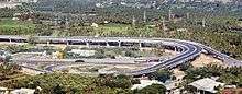
Ernakulam Palarivattom N.H. Bypass Junction in Kochi, Kerala
-

Kollam Bypass in NH-47 at Mevaram, Kerala
-
.jpg)
NH 47 in kerala
-

The Kochi Bypass, part of National Highway-47
-

Coimbatore-Cochin stretch of NH-47
-

NH 47 Kochi bypass in Vyttila
-

NH-47 in Kerala
-

NH47 Toll Plaza at the entrance of Erode district near Vijayamangalam on Coimbatore-Salam Section.
-

NH-47 tollplaza at Salem, Tamil Nadu
-

NH 47 at Thrissur City
-

NH 47 at Thrissur City
-

Sign board on NH 47 at Thrissur City
-

The busy Aroor - NH-47 bypass - Edakochi junction in Kerala.
-

NH 47 in Trivandrum, Kerala.
-

NH 47 in Thrissur.
-

NH 47 Vyttila junction in Kochi bypass.
-

NH47 at Attingal, Trivandrum district.
See also
References
| Wikimedia Commons has media related to NH 47 (India). |
- Openstreetmap 969534 National Highway 47 (India)(old numbering) on OpenStreetMap
- ↑ National Highway 47
- ↑ "National Highways and their lengths". National Highways Authority of India. Retrieved 2009-02-12.
- ↑ "NS&EW Corridor Map". National Highway Authority of India. Retrieved 2011-02-10.
- ↑ "NS&EW Corridor Chainage Chart". National Highway Authority of India. Retrieved 2011-02-10.
- ↑ "National Highway 47 Driving Directions Map, Kanniyakumari to Salem". mapsofindia.com.
- 1 2 "Land acquisition issues may delay widening of NH 47". The Hindu (Chennai, India). 2009-12-04.
- ↑ "Now, jump red signal and get caught on cameras". The Times Of India. 2012-03-14.
