Naniken River
| Naniken River Irish: An Nainicín | |
|---|---|
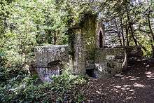
 Folly bridge in St. Anne's Park | |
| Main source | Santry |
| River mouth | Dublin Bay by St. Anne's Park |
The Naniken River (Irish: An Nainicín) is a minor river on the north side of Dublin city, Ireland, one of more than forty watercourses monitored by Dublin City Council. It is culverted for much of its upper course, and visible for its entire lower course.
Course
The Naniken rises in the vicinity of Santry Lane, between Santry and Ballymun, passes through Beaumont and Artane, then under the Malahide Road near the Artane Roundabout, then under Harmonstown and into Raheny in a culvert under a laneway.
In Raheny, it once formed the boundary of the Church of Ireland glebe (rectory lands). The river passes under Howth Road and forms a major feature of St. Anne's Park, running through the Dublin City Millennium Arboretum, and then in a valley, with some artificial features including ornamental bridges (one removed for safety reasons in the 1980s), supplying the Duck Pond (or Old Pond), and entering the western half of the "lagoon" (also known as Crab Water or Raheny Lake) behind North Bull Island. The line of the Naniken from its mouth marks the boundary of the civil parish of Raheny with that of Clontarf, and the beginning of the Raheny portion of the Bull Island.
Link to River Santry
There is a drainage link between the Naniken and the Santry River, at the western end of Kilmore West, to reduce the general flow from the river's upper reaches, and to deal with flooding or overflow situations.
Popular culture
The river rates a passing mention in Roddy Doyle's book "A Star Called Henry".
References
Bibliography
- Doyle, Joseph W. (2012) [2008]. Ten Dozen Waters: The Rivers and Streams of County Dublin (5th edition). Dublin, Ireland: Rath Eanna Research. pp. i–iv, 1–50 + photos and map. ISBN 978-0-9566363-4-8.
- Sweeney, Clair L. (1991). The Rivers of Dublin. Dublin, Ireland: Dublin Corporation. pp. 1–115, inc. many maps. ISBN 0-9505301-4-X.
| ||||||||||||||||||||||||||||||