Nakadomari, Aomori
| Nakadomari 中泊町 | ||
|---|---|---|
| Town | ||
|
Tatsudomari Line between Kodomari and Cape Tappi | ||
| ||
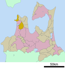
 Location of Nakadomari in Aomori Prefecture | ||
 Nakadomari
| ||
| Coordinates: 40°58′N 140°26′E / 40.967°N 140.433°ECoordinates: 40°58′N 140°26′E / 40.967°N 140.433°E | ||
| Country | Japan | |
| Region | Tōhoku | |
| Prefecture | Aomori | |
| District | Kitatsugaru | |
| Area | ||
| • Total | 216.33 km2 (83.53 sq mi) | |
| Population (April 2012) | ||
| • Total | 12,275 | |
| • Density | 56.7/km2 (147/sq mi) | |
| Time zone | Japan Standard Time (UTC+9) | |
| Symbols | ||
| • Tree | Hiba | |
| • Flower | Chrysanthemum | |
| • Bird | Barn swallow | |
| Phone number | 0173-57-2111 | |
| Address |
434 Kameyama, Nakasato, Nakadomari-machi Kitatsugraru-gun, Aomori-ken 037-0392 | |
| Website | Nakadomari Town HP | |
Nakadomari (中泊町 Nakadomari-machi) is a town located in Kitatsugaru District of northeastern Aomori Prefecture in the Tōhoku region of Japan. As of April 2012, the town had an estimated population of 12,275 and a population density of 56.76 persons per km2. Its total area was 216.3 km2.
Geography
Nakadomari consists of two discontinuous areas on Tsugaru Peninsula, one area on the northwest coast facing the Sea of Japan and the other area inland in the center of the peninsula. The town has a cold maritime climate characterized by cool short summers and long cold winters with heavy snowfall.
Neighbouring municipalities
History
Nakadomari was created on March 28, 2005 as a result of the merger of the town of Nakasato and the village of Kodomari, both from Kitatsugaru District.
Economy
The economy of Nakadomari is heavily dependent on agriculture and commercial fishing.
Transportation
Railway
Highway
Noted people from Nakadomari
- Kan Mikami – folk singer
External links
- (Japanese) official website
| Wikimedia Commons has media related to Nakadomari, Aomori. |
| ||||||||||||||||||||||||||||||||||||||||
|